Trip Planning Made Easier:
Topographic Mapping Software Reviewed
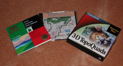
Six or seven years ago, the first thing you did when planning a backpacking trip to a new spot was to sit down with a topographical map index or hiking guide, try to figure out what maps you needed, order them from the US Geologic Survey, and wait for them to send you the maps. That was then, this is now. With the availability and relative low cost of digitized topo maps, that part of trip planning has become a snap. The biggest question remaining? What digitized map product should you buy? Well, like the guys from the government, we are here to help. For this review, we've compared three products: MapTech's Terrain Navigator, Wildflower Productions TOPO!, and DeLorme's 3D TopoQuad. These are by no means the only products, but together, they have a big chunk of the market, and since at least one of us had considerable experience with each product, it seemed like a good place to start.
For those of you unfamiliar with these pieces of software, digital topo maps are more than just electronic version of the paper maps. Each one of these products permits you to stitch together maps seamlessly, plot routes, zoom in and out, find topographic features, generate distance/elevation profiles, upload and download GPS waypoints, and print hard copies to carry with you in case you don't feel like hauling your notebook computer on your hike. As you might expect, the differences in these products, and their resulting usefulness to hikers, bikers, canoeists, and other self-propelled outdoor types, lie in the details, and that is what we discuss below.
We rated the products based on the following criteria:
Map Coverage and Prices: As of the summer of 2000, complete map coverage was available for all 50 states in 3D TopoQuad. Some states could be covered with one $100 set, while larger states require two. Terrain Navigator covers 38 States, and with their recent price drop, you can now get two or three states (eg., Colorado and Utah; North and South Carolina, and Georgia) bundled for $150. Or, you can purchase parts of states for $50. Also, MapTech has all the National Parks in their "Take-a Hike" Series at $99 per CD. TOPO! takes a different approach, focusing on areas noted for their high interest to outdoors types (Cascades, Sierras, Smokies, Northern Appalchians, etc) The individual packages run $50 for one or two CD's worth of maps. TOPO! also has all the National Parks Trails Illustrated maps in a big package (for $169) or in several smaller packages. They have also started to release complete State or Regional series (including shaded relief maps) for $200 per package, but we have not tried this product yet. Unfortunately, as of this writing, the only product to cover the entire state of Tennessee is 3D TopoQuad, although Terrain Navigator has coverage for the AT and the Smokies park (along with coverage of the other side in their North Carolina Package). TOPO! has coverage of the Smokies, the southern Cherokee, Nantahalla, as well as the Pisgah, Northern Cherokee National Forests, and Mt. Rogers NRA in SW Virginia. GPS software is included in the DeLorme and MapTech products, but TOPO! requires an extra purchase of $39, in the form of TOPO!GPS USA, or it comes bundled as part of their National Park series.
Map Scales Shown: All three products rely on the standard 1:24,000 scale (7 1/2 minute) quadrangle maps as their foundation. The differences come in the larger scale maps. 3D TopoQuad provides a scale-up from the quadrangles to their own, stylized topographical maps that are most useful for automobile travel. Terrain Navigator includes the 1:100,000 scale maps (and 1:125,000 scale for its National Park series). TOPO! uses three series of maps, starting always with a large scale (eg. 1:633,000) then dropping to 1:250,000 scale, and then to 1:63,000 This approach is very useful, because when the software loads, you have a regional view, which is much easier to navigate in. The overview approach is also used in Terrain Navigator. However, 3D TopoQuad's default view is at the most detailed level, from which you have to move out.
Viewing Maps: All of the products now offer seamless scrolling from one quad to the next. One of us liked the separator bar that Terrain Navigator provides, while the other didn't. 3D TopoQuad provides the option of leaving the separators in or taking them out. Unfortunately, the viewing screen clarity on the quads is much poorer with 3D TopoQuad. Terrain Navigator and 3D TopoQuad also provide magnifying capability, but the clarity problem with 3D TopoQuad persists at magnification. It appears that their quadrangle scanning process was faulty.
Printed Maps: TOPO! seems to offer the most flexibility. It can lay down an optional printed coordinate grid (at any separation distance you want, very useful for GPS navigation support). The coordinates are printed nicely but discretely small at the sides of the page. And it is exceptionally easy to adjust the coverage that is being printed. Terrain Navigator has good print area adjustability, and does a fine job in its printing, but the user has only minimal control over the gridding, and the grid lines are heavy and obtrusive. 3D TopoQuad maps print much better than they look on the computer screen. However, while 3D TopoQuad will print on any size paper that your Windows printer can handle, it will only print an 8 1/2 x 11" image. It will not print a legal paper (8 1/2 x 14) size image, and printing to tabloid size paper (11x17") like some of the newer color ink jets can handle, requires a $100 "PlugIn."
Interface: Both Terrain Navigator and TOPO! have pretty good interfaces. One of the authors likes that of TOPO! a bit better (although he wished for a greater range of options for highlighting routes) , while the other prefers Terrain Navigator's. Both agreed that 3D TopoQuad's interface was less user friendly. Navigation was clumsy as best, the route plotting is hard to decipher, and the screen view lacks organization. 3D TopoQuad has what should be a nice feature: the ability to generate a 3D view of the terrain you're considering, and rotate or tilt it. But the dimensionality is crude (it seems to be generated from data vastly less detailed that what is on the quad sheet you are viewing) to the point of being more of a curiosity than a real navigation aid. And beware: while TOPO! and Terrain Navigator run nicely on a Pentium Class Windows 95/98 system, we noticed that 3D TopoQuad - in its three dimensional view - made our older machines (even a 450 Mhz Pentium II with 256 Megs of RAM) crawl. It wasn't until we got the software on to a 500 Mhz Pentium III with 128 Megs of RAM did the 3D features not choke the computer.
Terrain Profiling: All the products enable you to draw a cross section of the route you have plotted. TOPO!'s seems to be a bit more functional, in that one can control the size of the profile displayed. We noticed that Terrain Navigator's profiles seemed to be more coarse than we expected. One of us tracked this down, and were surprised to learn that even when you are in the 7 1/2 min quad view, Terrain Navigator actually gets is elevation data from the geo-referencing data set associated with the 1:100,000 scale map. So you can be scrolling your mouse across contour lines of the 7 1/2 min map, and have your elevation reading be constant. Both 3D TopoQuad and TOPO! appear to use the geo-referencing data off the 7 1/2 min quads. Thus the elevation readout for the point under your cursor is pretty close to that of the contour or point you are considering.
GPS Interfacing: All of the programs let you download/upload waypoints from/to most modern GPS units, assuming you have a cable and an open serial port with which to connect the GPS. But even here, we ran into some surprises. Without the aforementioned $100 "PlugIn," 3D TopoQuad does not support Universal Traverse Mercator (UTM) coordinates, to which are the ones most folks who use a GPS quickly switch their frame of reference. (UTM coordinates are a lot easier to use and understand on the ground.) Terrain Navigator supports a variety of coordinate systems and datums. TOPO! (actually, the $39 TOPO!GPS add on) provided some challenge as well. Even if the datum you are using on both your map and GPS is the 1927 North American (virtually all paper maps are) you have to upload/download waypoints using the 1983 datum setting. Otherwise, your waypoints could be off by as much as 50 meters. It took a third party to track this problem down for us.
Web Site Support: All of the products feature a downloadable or interactive product demo, but again, the details make the difference. TOPO! (www.topo.com) has a pretty useful website. Not only have they provided frequent product updates and bug fixes, they have free sets of trails, waypoints, and other nifty trail-related features for download, with links to supporting web sites. MapTech (www.maptech.com ) has a huge website, and lots of neat interactive maps, and have a solid product update history. But there were no extras. Delorme's 3D TopoQuad web site (www.delorme.com) had a small patch to update to a couple of new GPS units, but that was it.
Route Planning and Editing: All three products make it easy to sketch in a route, establish waypoints, and upload the waypoints to a GPS. However there are differences in how one edits, or modifies a route once it is drawn on the map. Such editing is often needed in the planning stage, and is convenient after the hike. Waypoints established in the field with the GPS need to be added to the digital file for future reference. This editing process is quite easy with DeLorme's 3D TopoQuad and Terrain Navigator. Existing waypints can be moved by dragging with the mouse and new waypoints can be added in a similar manner. WithTOPO!, however, one must go through a cumbersome process of manually entering new waypoint coordinates to move existing ones, and new ones can be entered only at the end of the route. To add new, intermediate way points in TOPO!, one must delete all existing waypoints back to the intermediate spot, and then reenter them in the new sequence.
Final Ratings:
Roger liked TOPO!'s interface, and the "feel" of the printed maps. They seemed like perfectly customizable topographic quads. He wished for greater coverage of more obscure places. He liked 3D TopoQuad's coverage (everywhere in the US) but found the interface counter-intuitive, the maps difficult to read on screen, and the lack of native support for larger scale printing and UTM coordinates to be very frustrating. MapTech's price drop and bundling of multiple states puts Terrain Navigator in a very strong position. There was nothing bad about the product, but the lack of the accurate elevation data kept it out of the excellent category.
George preferred Terrain Navigator. The Terrain Navigator scheme for moving around the map and shifting to other locations was slick and easy to use, and the screen viewing clarity and zooming capability was excellent. While 3D TopoQuad's elevation data were better than Terrain Navigator, that did not make up for 3D TopoQuad's poor screen viewing clarity and clunky manuverability. While 3D TopoQuad does provide almost infinite levels of zooming, the feature was not particularly useful for hike planning. It appears to have been designed for automobile travel.
Overall, both of us think that the good products are really slick and augment our outdoor experience by encouraging us to study the terrain over which we are planning to travel. And the ability to print custom maps with your own notes can lighten your load on a long trip. On several overnight backpacks over the past year, we have found ourselves carrying one sheet of paper when we would have been carrying four large quad sheets, since we were hiking in that proverbial spot where four quad sheets come together.
Two final notes: First, In early July, 2000, Wildflower Productions, the maker of TOPO! was acquired by National Geographic, the ultimate map people, and owners of Trails Illustrated. This may give a boost to the overall coverage of the product, but we'll have to wait and see. And finally, we did not evaluate these software packages in conjunction with realtime laptop computer tracking. Such usage is obviously not for hikers, backpackers, canoeists, and mountain bikers. Not yet, anyway.
One Final, final note: This article was originally published in October, 2000, in the Tennes-Sierran, the monthly newsletter of the Tennessee Chapter of the Sierra Club. The day before the authors were posting the article on this web site, DeLorme provided us with a free add-on, which is supposed to support larger (up to 11"x17") and UTM coordinates. While we have not tested this thoroughly yet, if the add-on works, it would eliminate the one of the primary criticisms of this product. Stay tuned.
For an older review of digital mapping software and GPS's, click here.
© Roger A. Jenkins & George Ritter, 2000