Rock and Thompson Creek Odyssey:
A Backpack in Tennessee's Canyon Country
One of the great things about hiking in Tennessee during the off season is that your "risk" can often be rewarded with a special treat: great weather when you least expect it. This was one of those fine occasions when the there was a fortuitous incongruity between the weather forecast and ground truth.
Several of us gathered outside one of the local backpacking shops, and as the leaders, we went through the mental gymnastics of trying to arrange a car shuttle, when only some of the folks had met us here - the others: what turned out to be two more dayhikers (our buddy Ray had joined us for the first half of the trip: given the doom and gloom weather forecast, and his just getting over being really sick, he did not want to risk an afternoon, a night, and the next day in the rain) and three backpackers, met us at the Big South Forks Bandy Creek visitor center. We eventually settled on a scheme which is too complex to remember, but I do recall it involved Ray shuttling in some of the backpackers to the starting trailhead.
We gathered the remainder of the dayhikers and backpackers, and picked up our permit for the Big South Fork part of the backpack, which now has a modest fee associated with it (about $1 each). Next, we headed over to our second land management agency of the day, to pick up our other permit. Our hike would start in the Big South Fork National River and Recreation Area, which is managed by the National Park Service. We would cross over into Pickett State Forest, where we would spend the night, and finish our hike in Pickett State Park. So we needed a permit from BOTH agencies.
 We stopped off at the Pickett Ranger Station, on Highway 154, and had another "interesting" experience with a ranger. While someone else wrote the permit for us, the ranger warned us that the weather forecast was for high winds and rains tonight, with likely severe thunderstorms and possible tornadoes. (We were aware of the weather forecast, but it looked like it might be through quickly, so we had decided to do the hike as planned.) Then the ranger proceeded to tell us that of the cabins in the park (you can rent these for a night or a week, and it is a neat experience, but I had not done so in
more than 20 years, and in that time, my tastes have changed), all but one was rented. I THOUGHT what he was going to tell us next would be something like: "So don't expect, if the weather turns bad, to be able to hike out and stay in a cabin, because they will likely all be full." Instead, he blew me away by telling us that if the weather did turn ugly, that his first responsibility was to the folks in the cabins, and he would have to make sure their electricity was turned back on first, and that we would be last on his list to take care of!! I was baffled at first, since his telling us that was akin to the guy in the stands that hawks Cokes and Hot Dogs at an NBA game telling one of the players on the floor that his first responsibility was to the folks in the stands. Why would the players expect the hot dog guy to feed them??!! We certainly did not expect this guy to come looking for us, and the mental image of someone who was clearly not in the greatest of physical condition stumbling around in the dark looking for a group of experienced backpackers on a rainy night nearly caused my to double up with laughter. Instead, I solemnly told him that we were experienced, and would definitely be camping above the flood plain of the
creek, and would be enjoying shelter from the highest winds because we would be camping on the floor of the
gorge. I suppressed my laughter until I was out of earshot, and rolling dow the Divide Road in our vehicles.
We stopped off at the Pickett Ranger Station, on Highway 154, and had another "interesting" experience with a ranger. While someone else wrote the permit for us, the ranger warned us that the weather forecast was for high winds and rains tonight, with likely severe thunderstorms and possible tornadoes. (We were aware of the weather forecast, but it looked like it might be through quickly, so we had decided to do the hike as planned.) Then the ranger proceeded to tell us that of the cabins in the park (you can rent these for a night or a week, and it is a neat experience, but I had not done so in
more than 20 years, and in that time, my tastes have changed), all but one was rented. I THOUGHT what he was going to tell us next would be something like: "So don't expect, if the weather turns bad, to be able to hike out and stay in a cabin, because they will likely all be full." Instead, he blew me away by telling us that if the weather did turn ugly, that his first responsibility was to the folks in the cabins, and he would have to make sure their electricity was turned back on first, and that we would be last on his list to take care of!! I was baffled at first, since his telling us that was akin to the guy in the stands that hawks Cokes and Hot Dogs at an NBA game telling one of the players on the floor that his first responsibility was to the folks in the stands. Why would the players expect the hot dog guy to feed them??!! We certainly did not expect this guy to come looking for us, and the mental image of someone who was clearly not in the greatest of physical condition stumbling around in the dark looking for a group of experienced backpackers on a rainy night nearly caused my to double up with laughter. Instead, I solemnly told him that we were experienced, and would definitely be camping above the flood plain of the
creek, and would be enjoying shelter from the highest winds because we would be camping on the floor of the
gorge. I suppressed my laughter until I was out of earshot, and rolling dow the Divide Road in our vehicles.
In total, our crew consisted of 11 backpackers, and 3 dayhikers. The dayhikers would hike most of the day with us, until we got to the point where we would make the first of two fords of Rock Creek, and from there, they would turn uphill, and make the 2.5 mile walk back to their cars. Our planned route was to start from the Blevins Cemetary, which can be accessed off the Divide Road, and follow for the first 6 miles or so what the hiking guides refer to as the Rock Creek Loop trail. To make matters very complicated, which is the case for many trails in the BSF, the Rock Creek Loop trail is concurrent with the John Muir Trail and the Sheltowee Trace Trail for part of its length. Then we would leave the Rock Creek Loop Trail, and hike along Rock Creek, making two fords of Rock Creek on the Sheltowee Trace Trail, climb up out of the Thompson Creek gorge, pick up the Hidden Passage trail - which runs concurrently with the Sheltowee Trace - heading generally southwest, unless you are heading north or east, because the trail is skirting a monster escarpment - until it comes to the Double Falls Trail, which we would follow back down into the gorge to our campsite. Suffice it to say that it pays to plan your route out carefully in this complex, convoluted terrain, and pay attention at key trail junctions.
 The first 20 minutes or so of hiking through second growth - or maybe third or
fourth growth - woodlands was pretty uneventful, but the scenery really improved as we headed down
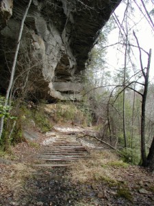
into the Massey Creek watershed. The west side of the creek used to be a logging railroad grade, and
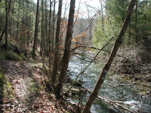
parts of the cliffs were blasted out to make way for trains. Across the creek are neat little waterfalls and small rock overhangs, referred to as rock houses in this country. You can even see the remnants of railroad ties. The weather was gorgeous: blue skies with puffy white clouds and temps in the 50's. Just perfect for hiking. We noted that Massey Creek had more water in it than I am used to seeing, and the drips off the cliffs overhead were definitely more substantial than usual, so it seemed like our ford of Rock Creek, still several miles upstream, could be more challenging than the last time that I had crossed it. One of the neat parts of this trip is when you can begin to see the walls that comprise the canyon of Rock Creek: their sheer size and vertical relief provides you with the sense that you really are in Tennessee's Canyon Country. After about an hour of swift hiking, I called for a lunch stop, right at the spot where the Sheltowee Trace splits off from the Rock Creek Loop trail and
heads for Kentucky. We were now in the bottom of the gorge, and had a good view of Rock Creek. It seemed a bit less threatening in reality than what it might have been in my mind. While they had enjoyed a considerable amount of rain in the last couple of weeks in north Central Tennessee, much of the volume had run off and must be filling the big rivers by now. I think it is a good idea to stop for a break once an hour or so. It keeps the walking from getting too onerous. Tish had done some easier trips, and she had indicated some concern about her ability to keep up on a longer walk (this would take us somewhat over 8 miles), so I thought the lunch break would give her a chance to catch up, but by the time Susie and I had dropped our packs, she was right there. No chance needed.
The first 20 minutes or so of hiking through second growth - or maybe third or
fourth growth - woodlands was pretty uneventful, but the scenery really improved as we headed down
into the Massey Creek watershed. The west side of the creek used to be a logging railroad grade, and
parts of the cliffs were blasted out to make way for trains. Across the creek are neat little waterfalls and small rock overhangs, referred to as rock houses in this country. You can even see the remnants of railroad ties. The weather was gorgeous: blue skies with puffy white clouds and temps in the 50's. Just perfect for hiking. We noted that Massey Creek had more water in it than I am used to seeing, and the drips off the cliffs overhead were definitely more substantial than usual, so it seemed like our ford of Rock Creek, still several miles upstream, could be more challenging than the last time that I had crossed it. One of the neat parts of this trip is when you can begin to see the walls that comprise the canyon of Rock Creek: their sheer size and vertical relief provides you with the sense that you really are in Tennessee's Canyon Country. After about an hour of swift hiking, I called for a lunch stop, right at the spot where the Sheltowee Trace splits off from the Rock Creek Loop trail and
heads for Kentucky. We were now in the bottom of the gorge, and had a good view of Rock Creek. It seemed a bit less threatening in reality than what it might have been in my mind. While they had enjoyed a considerable amount of rain in the last couple of weeks in north Central Tennessee, much of the volume had run off and must be filling the big rivers by now. I think it is a good idea to stop for a break once an hour or so. It keeps the walking from getting too onerous. Tish had done some easier trips, and she had indicated some concern about her ability to keep up on a longer walk (this would take us somewhat over 8 miles), so I thought the lunch break would give her a chance to catch up, but by the time Susie and I had dropped our packs, she was right there. No chance needed.
As the trail rolls over the floor of the gorge along the south side of Rock Creek, it undulates over micro-hills. Sometimes in is close to the water, sometimes a hundred yards away. Occasionally, climbs of a hundred feet are more are required to stay out of the water. The day continued its spring-like balminess: all I could hear from my rear is Susie complaining that she had overdressed for such lovely weather. To quote the Grateful Dead: "Every silver lining has its touch of gray." There are several nice camping sites along the creek, although most are for smaller parties than ours. I think our party of 11 had nine tents among us. It took us about 2 hours of brisk hiking - with of course, a nice rest stop - to make it to the first ford of Rock Creek. We had passed a junction with the Coffee trail, which fords Rock Creek and heads north, a few hundred meters downstream of our ford. Some of the folks ahead of me wanted to see my reaction, so they told me the two guys in the lead, Ron and John, both former or current college professors, had decided to take this trail. I suckered for the bait, and said "Well, they both seem to be pretty self sufficient: They will realize they are off target in a couple of hours." Then they told me they were only pulling my leg, at Ron and John's request.
Another source of my getting grief was the time. Specifically, what time zone we were occupying. I had declared, as the leader's prerogative, that we would use Eastern Standard Time throughout the weekend. Since many of these folks had hiked with me often, and know I like to operate like the airlines, and use local time almost exclusively, this "shift in policy forced me to endure plenty of ribbing. It is true that we start hiking in the Eastern time zone. But about 700 meters downstream of the ford, the trail crosses into Central Time, and then within 150 meters, crosses back into Eastern Time. When you actually reach the ford, you are in Central Time. It seemed just easier to establish one time, but that did not stop the grief and aggravation.
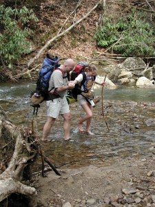 The first ford of the creek was lower-calf deep: refreshing but not too bad.
Most folks, at my suggestion, had remembered to bring some stream crossing shoes or sandals. However, Erica, with a little help from her not-so-little husband Brad, negotiated the rocky bottom in her bare feet. Everyone seemed to agree that while the water was brisk, it was not unbearably frigid. We hiked a few hundred yards upstream on the north side of Rock Creek, through an area that had been burned in some sort of big fire. Based on how things looked, I wonder if it was from some careless camper burning toilet paper which got out of control. Just about where the burned area stopped, it was time to re-ford the creek, just above the confluence of Thompson Creek and Rock Creek. There is a sign at the ford, so with some attention, the spot is not hard to miss. Most folks walked the short distance from the first ford in their sandals. After crossing, we stopped and put on our hiking boots. While the GPS showed less than a half mile straight line distance to our camp, I knew we had nearly 2.5 miles to go, starting with a steep climb out of the gorge. A note here: I have been tempted the many times I have taken this route to stay along the south side of the creek, and hike off-trail to the mouth of Thompson Creek. I have even tried to do it, but never successfully. The number of room-sized boulders that one has to negotiate on this side of the creek is daunting. I guess it might be worth a try if Rock Creek was too dangerous to cross, but you will save yourself a lot of time if you just take off your boots and ford the creek.
The first ford of the creek was lower-calf deep: refreshing but not too bad.
Most folks, at my suggestion, had remembered to bring some stream crossing shoes or sandals. However, Erica, with a little help from her not-so-little husband Brad, negotiated the rocky bottom in her bare feet. Everyone seemed to agree that while the water was brisk, it was not unbearably frigid. We hiked a few hundred yards upstream on the north side of Rock Creek, through an area that had been burned in some sort of big fire. Based on how things looked, I wonder if it was from some careless camper burning toilet paper which got out of control. Just about where the burned area stopped, it was time to re-ford the creek, just above the confluence of Thompson Creek and Rock Creek. There is a sign at the ford, so with some attention, the spot is not hard to miss. Most folks walked the short distance from the first ford in their sandals. After crossing, we stopped and put on our hiking boots. While the GPS showed less than a half mile straight line distance to our camp, I knew we had nearly 2.5 miles to go, starting with a steep climb out of the gorge. A note here: I have been tempted the many times I have taken this route to stay along the south side of the creek, and hike off-trail to the mouth of Thompson Creek. I have even tried to do it, but never successfully. The number of room-sized boulders that one has to negotiate on this side of the creek is daunting. I guess it might be worth a try if Rock Creek was too dangerous to cross, but you will save yourself a lot of time if you just take off your boots and ford the creek.
It was 3 pm (Eastern Time, of course) when we started climbing out of the gorge. The climb is very steep in places, and with all the recent rain, quite slippery in spots. I am told that Tish slipped and fell, and she reports having received some assistance from unknown parties who basically dragged her up the steep part, because she could not get her feet under her. Pay attention on the climb, and be careful of the wet rock. After topping out, and joining the Hidden Passage Trail, the Sheltowee Trace winds around the headwaters of an unnamed creek, and takes over a kilometer to cover what the crow could do in a couple of hundred meters of flying. Erica, who had to win the award for the toughest feet of the trip, was having a bit of a problem walking so close to the rim of the canyon. Because of the thickness of the vegetation in spots, there often is not much of an option. We bolstered her courage by holding her hand in places, and I confessed that I often get the heeby-geebies when I get too close to a lot of exposure.
We still had some sun at this point, but we could tell the clouds were moving in. It is always amazing to me that in this region of Tennessee, it can take so long to go such a little straight line distance. I was pushing pretty hard, as I really wanted to get the group into camp and get the tents and tarps up before the rain hit. The trail breaks out into the open at a nice overlook spot, called -creatively enough - Thompson Overlook. However, the trail is not well marked at this spot, and it is tempting to take the strong road off to the right. But that route takes you back in a little over a mile to the Group Camp at the State Park. Instead, one should follow the faint trail along the canyon rim, which becomes more pronounced as it goes back into the vegetation. The campsite we were headed for was directly below us, but as usual, the trick is finding the spot where you don't have to fly to get to the floor of the gorge. After about a third of a mile of walking on the rim or right below it, we got to the junction with the Double Falls trail. I looked up in the sky, and figured we had it made. The Double Falls trail descends into the gorge, but not so steeply as our recent climb out. We arrived at the campsite at 4:20 pm, which is one of the finest in the area. It is suitable for a huge party, but it is not heavily used. There is water in Thompson Creek, which I would treat if I had to use it, but there is water in a small stream easily accessible across Thompson Creek from the camp. I have drunk the water untreated from this source many times with no ill affects. However, as they say, your mileage may vary. For those readers who are into GPS, the coordinates of the campsite are Zone 16, 699,148 Easting, 4,049,799 Northing.
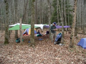 After getting our tent up, I went to work on stowing my gear. Having learned a hard lesson at Puppet Lake on our Sierras trip in 1998, I try faithfully to get my stuff put away before I head off for a bath. This time, I also worked on getting our tarp erected. John had carried our old one, so we put that up under the edge of our "good" one, and then Ron erected his, and eventually, Will would add a fourth tarp. Assuming it did not blow too hard, we would be well covered when the rain started. Thompson creek was particularly interesting at this spot. About 100 yds upstream of our camp, the water flows nicely in the creek bed. But in the distance down to the spot where this other, unnamed creek flows into it, the water disappears. It reappears downstream of the incoming side stream. Just like streams in Utah's canyon country. I would have not have been surprised to see this in dry times, but not when it had been so wet. Such is a tribute to the porosity of the sandstone which comprises so much of this region. Anyway, Susie and I freshened up a bit. Calling what I do a "bath" is like referring to a five minute burger stop at McDonald's as "dining." A quick rinse with a soapy rag, which gets wrung out in our cooking pots and tossed way above and beyond the flood plain, rinsing off with more creek water, more heaving of rinse water, followed by the "piece de resistance" standing in the creek and pouring water over my body. I convince myself this is clean, although I know that a skin smear of bacterial loading would indicate otherwise. I felt good, anyway.
Dinner was a long, drawn out affair, with the tarp complex being the social center for the evening. Most everyone dropped by for dinner, or to chat, and then stopped over at the campfire that we had built an appropriate distance from the tarps. Since the rain had not yet started, there was only a minimal amount of huddling under the tarps. Susie and I cooked a long time, as we baked brownies in a plastic bag on our Bakepacker and made fresh brewed coffee after we finished our main course. The makers of the Bakepacker say you can not bake such kinds of things successfully with the device, but we have found my using low-fat brownie mix, and baking half a box in 35 minutes from the time you come to a full boil, you end up with something that is well cooked and mega-tasty. Usually, Susie and I are some of the first to go to bed, but tonight, we were some of the last. As we were getting ready to hit the sack around 9:30, someone looked up and remarked that the sky was perfectly clear. Indeed, we were treated to lots of stars, but in the back of my mind, I was wondering if the storm was just sucking it in for a big hit.
Day 2
About 2:30 am, we both woke to the pitter patter of little rain drops on our tent, and felt like we needed to get out and make a mid-evening pit stop before the rain really got started. It was pretty gentle for the first half hour or so, but then the skies opened up, and it bucketed. Lots of thunder and lightning, although by my sleepy count of seconds following the flash, it seemed like all the lightening was more than a mile from us. (Professor John confirmed my measurements later that morning.) It rained pretty hard for more that an hour. It was hard to sleep, not because of any fear or consternation, but just because of all the noise. But eventually, it tapered off to a dull roar, and I must have drifted back off to sleep. (Note that elsewhere, it was a very very serious storm. The same front that moved through that night was responsible for a large tornado in northern Mississippi which killed two people. We had it pretty easy.)
We awoke at first light, and it seemed that the rain had tapered off to just a light mist. I decided to get out of the tent, as nature was calling much more insistantly. Naturally, as I started to get out, the rain picked up, and there is nothing quite like the woods on a soggy, rainy morning. Other folks were starting to stir, and Susie felt it her duty to dump the several hundred pounds of water that the tarps had collected overnight. What a mess that made, but necessary, because the full tarps were nearly touching the ground. John came over and started cooking up some breakfast. Most others seemed to want to stay close to their tents. As Susie and I were working on our exotic breakfast of instant oatmeal - backpackers's delight, for sure, I looked up outside the tarp ceiling and noticed some patches of blue sky. And it only kept getting better as we broke camp. It looked like we might really luck out, and be treated to a real backpacker's delight: having it rain only when you are asleep. Wow! As we rolled up our old tarp, we had noticed that it had leaked big time on John, and Susie did not have the heart to ask him to carry it for the second day: If we would have had a lick of sense, we should have burned it up in the campfire and dug out the grommets and carried them out.
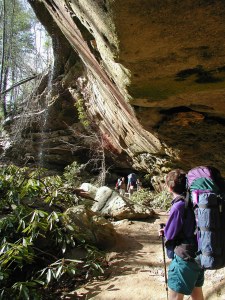 By the time we were underway (ca. 9:50 am), we were practically to a blue sky condition. The climb back up to the trail junction with the Hidden Passage trail was quick, and we began the serpentine walk which is so distinctive of this route. Within a few hundred yards, we were treated to our first massive overhang. It was 60 feet or so high, and maybe twice that much at the base. And there were water pouring off the overhang in several places. With the blue sky and sun coming in at a low angle (this was, after all, still February), the water seemed to sparkle. Our dispositions were pretty good too, having gotten through a storm that was advertized to be pretty rough. We hiked along, usually a few dozen feet below the main rim of the gorge, being treated to magnificent overhangs every few hundred yards. Our mood was also improved by the prospect of not having to haul our packs quite as far this day. Depending on whose book you use, our camp was 5 - 6 miles from the trailhead exit.
It is always a wonder to me when I look at the tiny pebbles that are encrusted in the sedementary rock that comprises so much of Pickett State Forest and Park. They are twins of the pebbles you find all over the south Jersey beaches where I spent my childhood vacations. To see what is so clearly a product of a beach environment so far inland is a reminder of the powerful forces that exist in nature, and the huge amount of time it has taken to form this land, relative to our seeming infinitesimal lifetimes.
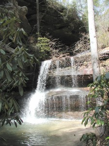 We all marveled at the rock houses and overhangs, and the micro-environments they shelter, and then it was off on a circuitous walk through the woods. Often on the Hidden Passage Trail, it is not clear why one is hiking in a certain direction, but have patience, and eventually, it too shall be revealed. We came to a pretty nice vantage point, dropped our packs at a small cliff, and climbed up to a really neat, but waterless campsite, about an hour or so into the morning's hike. You pretty much get a 360 degree view, and you can see that the sky was totally clear. Life was good. We hiked through second growth forest, never ranging too far from the edge of the escarpment. One can see that the gorge was getting more and more shallow as we made our way upstream, indicating that we were getting close to the headwaters of Thompson Creek. About noon, we came to the turn off for Crystal Falls, and this seemed like a pretty good place to stop for lunch. At various times, a couple of folks would hike back to the falls, and exclaim how neat it looked. I had never seen so much water coming over the falls. Usually, it is just a few seeming strings of diamonds, but today, those strings were huge ropes of surging water. Pretty fantastic.
After a luxurious lunch on the trail beyond the waterfall, it was time to hoist and drink in the next attraction, the one for which the Trail is named: Hidden Passage. Essentially, this is an arch underneath a huge overhang, one that seems more like a cave entrance than an overhang. The "hidden" part of things is that it is not clear at first how one makes one=s way through the jumble of rock. OK, maybe "hidden" is overdoing it a bit, but the Obscure Passage trail doesn't sound quite as sexy. Anyway, we took our time going through it, because with big packs on, it is a bit of a squeeze. From the arch it is only about 20 minutes or so to the end of the trail, which we got to at about 1:15. The car shuttle was a little complicated because, while I thought I had made it clear that Brad would walk the quarter-mile plus to the Park Headquarters, pick up his vehicle, and drive back to the trailhead to pick up the drivers to run the shuttle, everyone seemed to be in the mood for a walk. I asked Susie to stay at the trailhead and wait for Will and Diane, and then I too took off for the HQ building. Oh well, it truly was a great day for a walk.
© Roger A. Jenkins, 2001