
Dark Canyon 2000
You Can't Go Home Anymore
Down the Sundance Trail
Sunday, May 7
 Finally, a hiking day! After some reassuring words from the motel proprietor, indicating there had not been a drop of precipitation in six weeks (a harbinger of the upcoming water situation), and a quick continental breakfast at the motel, we gassed up and were out of town right at the scheduled hour of 8am. Heading west along Utah 95, we cut through Comb Ridge and headed for the turn to Natural Bridges. We pulled slowly up around Maverick Point and through the Bears Ears. We bumped and ground our way to the Woodenshoe trailhead, pleasing us immensely, since 17 years ago the road was washed out, and we had to park the shuttle vehicle 8 miles short of the trailhead. Then we squeezed all 11 of us and our fully loaded packs into the 12 passenger van, and headed on out. The shuttle between the two trailheads is long: we arrived at the official Sundance Trailhead at 11:40 pm, 2 hours and 10 minutes after leaving the high elevation trailhead. The clouds had built up a bit, as had the wind. Anything which was not weighted down became airborne. At least it would be cool. After lunch, in some form or another, we finally made all the pit stops, checked all the gear one last time, did the obligatory group picture, and so there was nothing left to do but head for the Sundance Trail.
Ah, the Sundance Trail: the stuff of legends. 17 years ago, when we did this hike, our experience was enough to cause me to plan a whole ‘nother approach to this route. Rather than paraphrase the experience, here is the unexpurgated entry from my trip journal in 1983.
|
Sat. May 28, 1983
Up @ 5:15 with incredible hangover. Felt awful. Breakfast of pancakes and crummy OJ at coffee shop & on the road by 6:50 am. Lots of flooding in central Utah. Spent a little time at visitor center in Capitol Reef. Had lunch in Hanksville @ 11 am. Overpriced hamburger, but the only game in town. Finally saw Lake Powell Bathtub at ~noon. Can't believe the(y) flooded the canyon. Started the shuttle @ 1 pm. Sure enough, road is washed out right below Bears Ears Pass. Looks like it'll be some time before they fix it. Dropped car info off at Nat Bridges. The approach road to Sundance was slow going - took us nearly an hour to go 13 miles - couldn't get van all the way to parking area. Finally, we started hiking at 4:30. The trail off the jeep road was poorly marked & RAJ overshot with GR (George Ritter). Others found it, but my goof cost us 30 valuable min. Sue Fischer chewed me out royally. Oh well. Anyway, it was tough to find the descent point. You just walk out on a promontory & you think it's the end of the world. But RAJ finally found the route, so we started down. Wow - what a tough descent. I led the way for a while, but got tired, so Ray took the lead. I thought everyone was behind me, but they got strung out. My legs were quivering. It was tough - extremely tough, especially with the heavy pack. Made it to the bottom at 8 pm. Sue and George were down shortly. Lance and Carol were still up in the rocks, but making good progress. BJ & Ellen were way, way up and in trouble. Well, I was so hot and thirsty I had to get to camp. So I made Gator Aide, drank a whole quart, set up my tent, and took off with Sue and Ray to re-climb the talus and help BJ and Ellen. I was pretty frustrated, cause it seemed that after 1 1/3 hours they should've made better progress. Andy was helping BJ (he'd stayed up there). Anyway, I took BJ's sleeping bag. Sue took the rest of her pack. I guided BJ down. We all finally got to camp at dark. Dinner in the dark, bath in the dark, & sleep by 11:30 pm. |
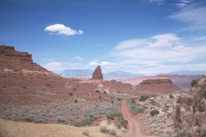
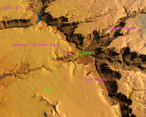
 Based on that, we had designed the trip with a day to get into position. Of course, things are never the same. By now, there really is an official trailhead, with a sign-in register. There were several vehicles parked there, altho a couple were leaving. The trail starts right where it is supposed to, near where we parked the van at Zone 12, 569,161 East, 4,189,049 North (note that all the coordinates in this report are given in UTM designation, NAD27). We rolled at 12:30 pm, right on schedule. Click here for an interactive topographical map of the route.) After going through some scrub Cedar and Juniper, the path breaks out onto a huge sheet of slickrock. At that point, the path disappears, but the route curls left down through the drainage. (Click here for a 3D rendering of the route.) There is one spot which requires a bit of negotiation. Some folks accomplished this using the time-honored method of butt-sliding. I opted for the hip-hop method, but it was not too difficult.
 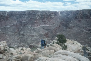 Just sorta warms you up for what is to come. The route to the top of the Sundance Trail is more scenic than going down the old jeep road, but you do miss the spectacular view of the scree slope that passes for the way into Dark Canyon. For people who are bothered by heights, the new route is probably better: no point in seeing something and stewing about it for an hour or so it will take to get to the spot where you really have to start paying attention.
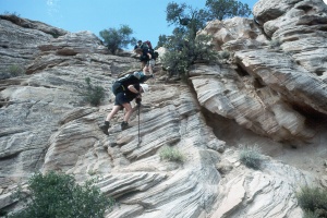
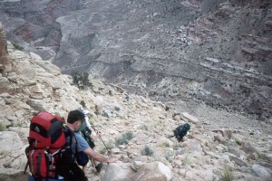
Actually, there are a couple a nice spots on the way in, where you are losing the 200 feet or so to actually get to the point where things are really interesting, where you do have to pay a lot of attention. At one spot, you need to get down a 30 foot wall or so, and another point where you just have to take your pack off and hand it down. We followed the strongest path out to the spot where it seems like the earth just falls out from underneath you. You keep walking closer and closer to the edge, and you still can't see anything below. Of course, there is something there, it's just that the angle of descent is pretty steep. 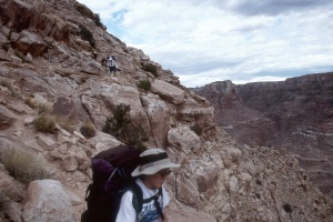 We rested and started down the Sundance Trail about 2:20 pm. Nice and relaxed. Certainly, 17 years have had its effect on the route: for one thing, it is pretty easy to find. There are rock cairns occasionally, but enough people have been up and down that it is pretty easy to follow. It is steep and the gravel is loose, and you do have to pay really good attention. But it is about an hour and 20 minutes or so of unpleasantness. A lot of things made the descent easier this time: it helped to be starting at 2:20 rather than 7pm. It helped to be well hydrated and not hungover, it helped to have real boots (as opposed to the French Canvas hiking boots I wore in ‘83), it helped to have knee braces and an internal frame pack, and it helped to be mentally prepared. We all got down in 75 - 90 minutes, not different at all from ‘83, when fading light and fear of being stranded up on the slope was encouraging my precipitous descent. So 17 years had not made a performance impact.
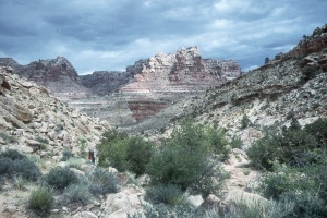
 We rested for a bit and headed out to where we had camped previously, on a hill about the confluence of the "canyon" which is at the base of the Sundance Trail and Dark Canyon. We got there about 4 pm, and some of us set off looking for a campsite. There was a bit of urgency in the air, along with wind and threatening rain. There was a small party camped up from the confluence a few hundred meters. Lance and I passed them, and searched further up, but could not find anything much better so we turned around and decided to stay right at the confluence. (Note: had Lance and I gone upstream just a bit further, to 572,272 East, 4,190,129 North, we would have seen a nice spot to camp: a sandy bench with lots of space and a couple of big cottonwoods.) The confluence spot was not great. In fact, the camping was sufficiently cramped that Dolph, Ray, and Barbara decided to move upstream of the other group about 100 meters. Ray reported later that the male of the group had complained to him that the three of them were camping too close. Ray, in his less that totally diplomatic style, reminded him that the three of them were nearly out of sight, and with rain on the way, there was no way in hell they were moving.)
 Supper was rain-free (following a brief, rock wetting shower) and burritos made with Southwestern Black Bean Couscous when we should have had Humus. It was tasty but very runny and messy, and I heard about my mistaken purchase the rest of the trip. I enjoyed the tortillas by themselves. Everyone hit the sack early, so we got in our tents, and started roasting. It was so hot, that we just laid on top of our sleeping pads, with nothing covering us. Not as hot as it had been on the previous trip (the low the first night was 75 degrees), but not cool enough to be comfortable. During the night, with the breeze/wind, it did cool down enough, and I woke to find Susie had spread out her sleeping bag on top of us. Several bands of showers moved through during the middle of the night. Not big rain, just enough to remind us that it is not always dry in the desert.
© Roger A. Jenkins, Suzanne A. Mcdonald, 2000