
Escalante Canyon 1999
Escape from the rising waters
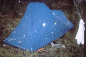 What I thought had been rain had been in fact rain mixed with sleet. There was a lot of frozen precip on the tent when we got up, and it was still snowing, or raining, or whatever. It did not seem to want to let up. The clouds were very low, and I could see that there was snow in the upper elevations, like a few hundred feet above us. Snow-covered sandstone can be virtually impossible to cross. We gathered up against the overhang, tried to keep warm with the fire, while Sue reported back that the river was up about an additional foot, and seemed to be rising. The interesting thing about hiking with very experienced - and intelligent - backpackers is that everyone seems to work together. It was clear to everyone that the trip as we had planned it was over. It was now: how do we get out. Actually, we had several potential escape routes. One involved no river crossings at all: A&S had found a route up to Brigham Tea Bench from a slot immediately east of camp. Based on our '86 experience, I KNEW we could get down to the floor of the Gulch (above the narrows and pour off). It would mean a long walk up The Gulch, and it would dump us out on the Burr Trail, miles and miles from Boulder, but we could get out.
The alternative, which everyone seemed to go for, would be to cross the river very carefully three times, and pick up the trail we had been on yesterday. Since in some places, developed trail was visible, we figured it had to go out. My guess was that it lead to the top of a mesa directly west of camp. From there we could easily (hah!!) go cross country, hit the Old Sheffield Road, and walk out to Highway 12. I knew we could not make it all the way to the highway that night, but it seemed like our best shot, because it dumped us out of the highway just about 3 miles west of the bridge over the River, where Will had said he would meet us at 8:30 on Saturday morning. Of course, this highlighted another complication: Will had both the keys to the car (2 miles east of the bridge) and the van (still in Harris Wash). There was a lot of concern that we had let Will do his own thing at a potential cost to the group. It was certainly possible that Will and Mark could not get out from where they were, or could get hurt in the attempt. So even if we made it to the road, there might not be keys for a vehicle. I was less worried about that, because I knew that it this part of the river, Boulder Creek provides half the flow to the Escalante. If Will and Mark were above Boulder Creek, which they were supposed to be, we should have been OK. This did not make many folks feel any better, and the general sentiment seemed to be that we would not let this happen again.
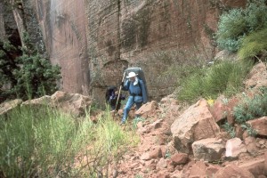
But that was for the future. We first needed to make it to Highway 12, or at least the Old Sheffield Road. Between gaps in the showers, we hauled our gear to the slight overhang, so we could sorta pack up dry. However, our tent was absolutely soaked. Nice and heavy. We waited until everyone was ready to leave, because we knew we had to do the river crossings as a team. The first one was deep, but not too bad. The second one was nasty. I took the upstream position, with Susie between me and Barbara. About 2/3 of the way across, it got up to Susie's waist. With the current flow, and the fact that the bottom of her pack was now in the water increasing her buoyancy, it was harder for her to hold Barbara, who was starting to get lifted off her feet. I called for help, and someone came into the water to give us a hand. It was cold, but it was much easier than the Chitistone crossing in Alaska. The third one required a bit of an unususal trajectory thru the water, but it was not too bad. But it was pretty obvious that there was no way we could have made any time going up the river. We figured probably 30 crossings just to get to Boulder Creek's mouth. After our third crossing even though we were chilled, we decided against building a fire, knowing we would warm up as we began the climb.
 By the time that we started the climb, most of the snow had melted, so we did not have that issue to deal
with. We got to the knob we had been at the day before (5355 feet) and did a quick recon. We could see
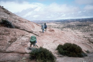
some evidence of a trail leading off to the WSW, into a slight drainage. We spread out, looking for more evidence that someone had been this way in the last 50 years or so. Ray was up ahead, and he took a hard left, looking down into a crack which appeared to have a pile of rubble at the end of it. He waved us forward, and I thought he had found a couple of footprints or so. But no, the rubble heap that sloped up to the top of the crack (which seemed to be only 20 feet wide) had built into it a steep but nicely constructed horse trail. We were all pumped, and spirits were very high. It even seemed to be clearing off a bit. We got to the top of the pitch, and took a rest.
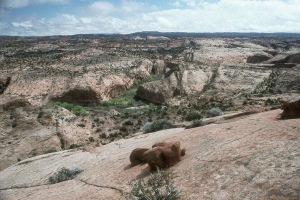
George was a bit slower than ususal, but he was not falling behind. I continued to be in awe of his discipline and determination. At the top, we descended a bit, and then traversed around, and started to climb. We got higher and higher on the slickrock. We came to an interesting spot: great views, but a very narrow flat shelf in some rounded slickrock, that seemed to fall away forever. I scouted it, and found some evidence of horseshoe scuffs on the rock, so decided that this must be the way. It seemed to go like this for a while, but we continuing to make progress. We stopped for lunch and a GPS reading (4175860 N, 471208 E, Zone 12). Lunch seemed to be very quick, however. First, the weather was closing in again, and second, we knew that, given how far we had come, we still had a long way to go: we could still see camp in the canyon below us.
By the time that we started the climb, most of the snow had melted, so we did not have that issue to deal
with. We got to the knob we had been at the day before (5355 feet) and did a quick recon. We could see
some evidence of a trail leading off to the WSW, into a slight drainage. We spread out, looking for more evidence that someone had been this way in the last 50 years or so. Ray was up ahead, and he took a hard left, looking down into a crack which appeared to have a pile of rubble at the end of it. He waved us forward, and I thought he had found a couple of footprints or so. But no, the rubble heap that sloped up to the top of the crack (which seemed to be only 20 feet wide) had built into it a steep but nicely constructed horse trail. We were all pumped, and spirits were very high. It even seemed to be clearing off a bit. We got to the top of the pitch, and took a rest.
George was a bit slower than ususal, but he was not falling behind. I continued to be in awe of his discipline and determination. At the top, we descended a bit, and then traversed around, and started to climb. We got higher and higher on the slickrock. We came to an interesting spot: great views, but a very narrow flat shelf in some rounded slickrock, that seemed to fall away forever. I scouted it, and found some evidence of horseshoe scuffs on the rock, so decided that this must be the way. It seemed to go like this for a while, but we continuing to make progress. We stopped for lunch and a GPS reading (4175860 N, 471208 E, Zone 12). Lunch seemed to be very quick, however. First, the weather was closing in again, and second, we knew that, given how far we had come, we still had a long way to go: we could still see camp in the canyon below us.
 After lunch, we had to go through the most incredible mud I have ever been in: like quicksand on top of the mesa. It was dark red clay-like material, which seemed to ooze everywhere. It was one step forward and two steps back. Lord, it was miserable. Finally, we were on top of the small mesa which divides the Escalante canyon from the heads of the drainages which drop down into the western cross streets of Side Street. Our next challenge was the descent of sloping slickrock to the SW. We wanted to go NW, but the rock was too steep, so it took us a while to get around the western head of Side Street. Route finding on slickrock can be time consuming. After another break, and trying to get everyone back together, we made a GPS confirmation of where we thought we were, and headed SW again to hit the Old Sheffield Road. We made it at 3:15 PM, 5 hours after leaving camp. For some reason, Susie was under the mistaken impression that when we hit the road, we only had 2 miles to go to Highway 12. Of course, she had that impression without having looked at the map. (I find it interesting - not bad, but certainly not comfortable for me, that some folks do all this stuff without studying the maps as much as I do. Of course, they might say I am obsessed, so I guess it all averages out.) She was pretty discouraged for a bit, mainly cause her feet were killing her only slightly more than the huge, flesh-eating blister on her right hip. And then, all of a sudden, it was like someone lit her fire. Lord have mercy, Susie got her mojo working, and I did not have a prayer of keeping up. We had decided we would walk the road until 5:30 PM or so. Not that we could not have gone on longer, but there seemed no point in our killing ourselves, since without the vehicle keys, we were stuck. (The entire subject came up again about not letting the group get in this position. I would say that there is near zero chance of my being allowed again to delegate the keys to someone not staying with the main party.) As we walked out the road, we got hit by more rain. Quite unusual weather.
 I don't know if Susie ran out of gas, or if she came to a convenient stopping point, but she went over to a slab of rock, put her pack down, and lay down on top of it. I laughed so hard, because she proceeded to nearly fall off of it backwards. It was about 4:30 or so, and we all needed a break. From our vantage point, we could see that the road was going to climb over some low hills, which might offer a camping spot, so we decided that would be home for the night. I was surprised to learn that even though I had said that this would be a dry camp, not everyone had carried extra water from the river. We found a spot among some juniper trees, not very pretty, but we were right up against some rock slabs, which were wet and sandy, but at least semi-clean, on which to drop our packs and cook dinner. Since there was no water in which to bathe, I thought I would go out and see if I could locate some pools of rain water for the folks that were dry. I was successful. It was not much, but it was wet. Susie and I had our last dinner, freeze dried Mountain House Lasagna, my favorite of those, and it tasted good. Nothing like a self-rescue, so to speak, to make you feel good. We all just wished that the weather would cut us some slack and let us get the van out of the mire that we KNEW it had to be stuck in down in Harris Wash. We made up a plan that the fast hikers would leave first, get out to the highway, and while one group was trying to find Will and Mark, Dolph would try to hitch a ride into town, and see if we could not pay someone a big pile of $$ to take a 4WD tow truck with chains and pull out the van. George, Susie and I would pull up the rear, because someone had to sleep in and enjoy themselves. So we all hit the sack pretty early that night.
© Roger A. Jenkins, 1999