
Slickhorn Canyon 1997
Above the San Juan
 We woke to some very warm weather. We had breakfast down in the creek bed. We had gotten going pretty early 'cause the plan was to meet W&B at the rock cairn that we had put up on the access point to the bench at 8:30 am. That meant being underway by 8 am. As we were finishing up breakfast, this cold wind blew up and we could see some mean clouds rolling in. Looked like we were in for an interesting day. As we started up the access point to the bench (which is at ca. 4,130900 North, by 577,900 east) it started raining, hard, wind driven rain, the kind that stings when it hits. There was not a lot of water coming down, but it was breezy wet hiking. People who had brought their rain pants (not me) were glad to have them. We all gathered at a big boulder out on this very wide bench (at some
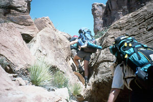
points, maybe 75 yds wide) to get out the wind, and look at the petroglyphs in the rock face, and let everyone catch up. The rain spit intermittently. But following the path was absolutely no problem. Basically, it is the solution to travel in this part of the canyon. Unless you just want to work hard in the boulders in the creek, if you want t get down to the river, you would take this path along the bench until you come to the old road bed, and turn downstream and head down to the river on the old road. For us, we just cruised on top under the clouds and cool breeze. The going was very easy, after what we had been through in the canyon bottom. The gully turned out to be just a little tricky. If you took the low route, like Susie and I and Ray, you had to be especially careful with one step (lots of exposure).
Or you could take the high route, do a little boulder work, and have minimal exposure problems. Of course, Barb A had the best idea. Take the low route, but let Ray carry your pack for you. She ain't too dumb.
We woke to some very warm weather. We had breakfast down in the creek bed. We had gotten going pretty early 'cause the plan was to meet W&B at the rock cairn that we had put up on the access point to the bench at 8:30 am. That meant being underway by 8 am. As we were finishing up breakfast, this cold wind blew up and we could see some mean clouds rolling in. Looked like we were in for an interesting day. As we started up the access point to the bench (which is at ca. 4,130900 North, by 577,900 east) it started raining, hard, wind driven rain, the kind that stings when it hits. There was not a lot of water coming down, but it was breezy wet hiking. People who had brought their rain pants (not me) were glad to have them. We all gathered at a big boulder out on this very wide bench (at some
points, maybe 75 yds wide) to get out the wind, and look at the petroglyphs in the rock face, and let everyone catch up. The rain spit intermittently. But following the path was absolutely no problem. Basically, it is the solution to travel in this part of the canyon. Unless you just want to work hard in the boulders in the creek, if you want t get down to the river, you would take this path along the bench until you come to the old road bed, and turn downstream and head down to the river on the old road. For us, we just cruised on top under the clouds and cool breeze. The going was very easy, after what we had been through in the canyon bottom. The gully turned out to be just a little tricky. If you took the low route, like Susie and I and Ray, you had to be especially careful with one step (lots of exposure).
Or you could take the high route, do a little boulder work, and have minimal exposure problems. Of course, Barb A had the best idea. Take the low route, but let Ray carry your pack for you. She ain't too dumb.
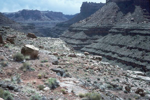
Anyway, we all got around the gully, and got out on the flat land. We could see the gorge of the San Juan canyon really well now. There were some beaches to camp on at the mouth of Slickhorn, and we could see a few raft parties there. You could look down river, toward the mouth of Grand Gulch. It looked to me that it would be very difficult to get up river from the mouth of GG, because it looked the river undercut the cliffs as it got close to the mouth of Slickhorn. Certainly would require some scrambling.
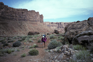
By 10 am, we had joined up with the old road coming in from Moki Dugway. It seemed very passable by any kind of wheeled vehicle. It looked like the weather would improve. We rested at a little stream where it came out of the formation., and let everyone gather up together. After our rest, we sailed along, almost like walking on a sidewalk. Naturally, folks started to string out. George was way out ahead, Susie and I were somewhere near the rear, and Will and Barb, usually brought up the rear. You could look out across the bends in the formation, and see members or our party walking along what looked like an extremely narrow shelf in some places, dwarfed by the size of the walls around them. There appeared to be no way that they could cross, short of being a fly on the wall. Of course, at it's most
narrow point, the shelf was usually 40 feet wide or so. Not to worry. We stopped on a little point overlooking the mouth of the canyon to the east of Government Bird Rock, and looked down on rafters playing in the rapids. We waived at them, but they did not see us, nearly 750 feet above the water level. The breeze was cool, and the sun warm, the hiking easy, and the views magnificent. It just doesn't get any better than this.
George had figured last night that it was about 6 - 7 miles from last nite's camp to the next one, and that we could cover the distance in about 3 - 3.5 hours. We are not sure whether the mileage was more, or the going slower, but we had been underway for 4.5 hours, and were not yet near the mouth of East Slickhorn. We pushed on, and came across a huge rock slide which blocked passage from the east for all but the most hardy mountain bikers. But east of the slide, it was clear that motorized vehicles had gotten this far to the west. Near the turn into East Slickhorn, we found a rock covered with petroglyphs just sitting out in the middle of nowhere. As the road starts up into the huge mouth of E. Slickhorn, it drops in elevation. George had placed some small ducks near this point, indicating the most efficient route was at constant elevation. George was waiting for us a couple of hundred yds along the bench, about 300 yds from the real mouth (at this elevation) of ES. We all caught up, rested for a bit, and then took off up into the jumble of rock that marked the mouth. I had previously indicated that the point where the bottom of the canyon turned green (vegetation on the topo map) looked like the first place that would be flat enough to camp (4,128, 550 North, 580,800 East).
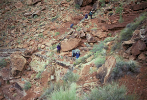
We immediately came to two major pour-offs. We could have climbed the first, if we really had to, but Lance had scouted them, and indicated that the second would be impossible to do directly. So it was scramble up into the boulders high above the stream bed, to find a way around. Find one we did, but it was not easy. It was a sea of room sized boulders, and the going was very rough. It took us 80 minutes to cover the first half mile above the pour-offs. But sure enough, when the crew (Susie was with them, cause I had fallen behind with Lance to assist him in his first scouting job) got to "green on the map", there was a lovely small campsite. By nestling our tents in small spots, we were able to squeeze all the tents in. Pools, running water, and shade (which we did not need this day) but the views were not big (actually, the canyon was quite narrow at this point) But we were home, at last. We had arrived at 3:40 pm, after leaving our previous camp at 8 am. 7.6 hours to cover mostly very easy distance. Maybe this crew is feeling it's age! (Actually, I think that the windiness of the route makes it a lot more than 7 miles.)
 The air cooled off quickly, probably because of the front that moved thru with the rain (I am speculating here: I think a front moved thru cause the temperature was dropping, not the other way around.) Anyway, by dinner time, everyone was dressed in PolarTek. We built a small fire downstream of our tents, not wanting the breeze to lift up hot ashes and burn holes in our tents. Unfortunately, the marshmallows in Barb's pack were eaten or smashed beyond recovery, so we just watched the stars come out. It has been much cloudier on this trip than previous ones, so we have not been able to enjoy the nite sky as much as I like to. Although I admit when you have to get up in the nite to take a leak, my prime focus is on balance, and not what is up in the sky. Ah, the passing of youth. This was our first nite to camp with Barbara and Will in a while, and it was good to have them back in the fold, so to speak. Even though I think that Will and I get on each other's nerves occasionally (that is probably because we have such strong personalities, and are usually more the leader rather than the follower type), he and she add a lot to my enjoyment of the trips, and I had missed them the last couple of nites.
This was another great day in canyon country. A little bit of everything, spectacular scenery, hiking which was not too tough, except when it was really difficult. Good company, weather most of the day was cool and sunny, and dinner was pretty good, even though it was freeze dried (Santa Fe Chicken). You know, I reflect on Sarah Boomers' writings of her trip to Patagonia, and she is always talking about how hungry she is. Yet she seems to be carrying plenty of food. I am not usually satiated when I go to bed, but I am never starving on these trips. I think that the difference between me and thin people, like Susie or Sarah Boomer, is that I always have a 30 day food supply with me, around my waist, so that reserve is always ready to be called upon.
© Roger A. Jenkins, 1997, 2006; Photo of bench hiker © Suzanne A. McDonald, 2006