Lost in Raven Fork
Day 1
Authors Note: Back in the 1980's, I was the outings chairman of the local Sierra Club group. I guess if you run perhaps 40 outings per year for 25 years, you are bound to have one or two snafu's. This one could have been much worse than it was. It really points out the need for everyone who ventures into the wilderness to carry the Ten Essentials with them. This is an edited version of a memo which I sent to all the other outings leaders in the local Group. I have added some explanatory notes in italics, and placed some images of the terrain these folks were moving through. The point of this article is not to place blame - there is obviously enough to be shared by everyone involved, including myself. I had done the same trip (although in reverse direction) three years previously. As the Outings Chairman, knowing the difficulty of the trip, I should have queried the leader as to his plans, but I didn't. That was the first of many mistakes made on this trip.
For those readers who have not hiked off-trail in the Great Smoky Mountains National Park, I can assure you it is quite an experience. It can be extremely rugged (a couple of buddies and I did the lower part of this same creek a few years later: it took us over 7 hours to cover 2.5 miles). The terrain can be extremely steep, and the vegetation so thick that you can not see your feet. In this particular valley, there are many places where your feet will never contact the ground: you bounce from one rhododendron branch to another. Many times, the energy expenditure per mile is 5 to 10 times what it would be on a maintained trail. Underestimating the ruggedness of the mountains can leave you exhausted, or worse. So sit back, relax, and enjoy this true story, safe in the knowledge that it was not happening to you.
| To: | All Group Outings Leaders |
|---|---|
| From: | Roger Jenkins, Outings Program Chairman |
| Date: | May 18, 1987 |
| Subject: | Preventing Disaster |
Last weekend, we had an unfortunate situation develop on one of our outings. Happily, no one was permanently injured, although at least one participant was unable to perform her job on the following Monday. Had the weather been only a little less ideal, one or more individuals could have died from hypothermia. The situation developed through a series of avoidable mistakes, one compounding on another. In retrospect, it is hard to believe that so many things can go wrong, but that's what happened at Chernobyl, too.
I have personally discussed the outing with four of the seven participants, including the leader. I have tried to sort out the facts and relate the important ones, so that we can all learn from this sort of mistake. Three years ago, I took the same route as that of the outing, except that I did the trip in the reverse direction. So I am familiar with the terrain and the difficulty of the outing.
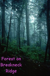
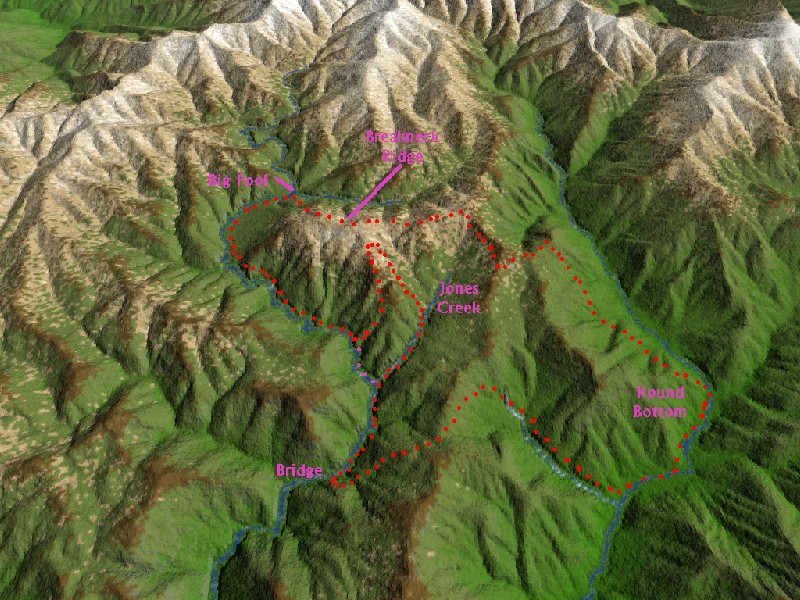
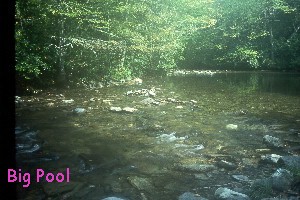
The outing as planned was a day hike, and involved an on-trail hike from the Round Bottom trailhead in the GSMNP, up to McGhee Springs backcountry site (#44) for lunch. Then, the party was to descend aptly named Breakneck Ridge on an abandoned manway to Raven Fork, near the Three Forks area, commonly called Big Pool. They would then proceed via either the creek or abandoned manway down Raven Fork to the Enloe Creek backcountry site (#47) - about 4.5 miles - where they would pick up a maintained trail back over Low Gap to Round Bottom. I would rate this hike as very strenuous. (Click here for an interactive topographical map of the trip.)
 (George and I had completed this same loop, going in the clockwise direction, three years previously. Having already done many of the trails in the area, including the manway down Breakneck Ridge, we suspected that this would be a very difficult hike. We left Knoxville at 4 am, drove like bats outta hell to get to the trailhead on the North Carolina side of the park by 6am. We were over Low Gap, and to the spot where the old manway going up Raven fork supposedly intersects the Enloe Creek trail by 8 am. It took us more than 5 hours to get to Big Pool, we got back to the car much earlier than we had expected to, 13 hours after we started the hike. Figuring we would be fortunate to get to the maintained trail near the McGhee Springs campsite before dark, we had brought extra flashlight batteries, and dinner. We had done the hike in the clockwise direction, because the tough part of the hike would start earlier in the day, when we would expect to have been fresher. Also, having been both up and down Breakneck Ridge, climbing up is much easier than going down. We wanted to take advantage of this on our trip.)
The party left Round Bottom at about 10:15 am on Saturday. They got to Big Pool at about 2 pm. Apparently, the differences in physical ability began to manifest themselves, as the group started to spread out, during the descent. Also, recent rains had substantially increased water flow in the creek, making crossing it, or - worse yet, using it as a highway - even more challenging. ( Click here for 220 Kb 3D overview of route.)
 The leader believed, based on his experience having taken this hike something like 9 times, that the party still had plenty of time to go down Raven Fork and at least reach the maintained trail by dark. However, it soon became obvious that movement down the creek would require a considerable amount of stream crossing and rock hopping, and that the party was not doing this very expeditiously. Water was deeper than anticipated, and many of the participants became chilled. One of the women was wearing cotton blue jeans, which became soaked during all these crossings. The leader expended a considerable amount of time, and energy, searching for the manway which runs along the east side of the creek with no luck. (When George and I had done the trip, the manway was really only a memory. Without a good deal of use or maintenance, a rain forest, which this elevation of the Smokies approximates, will quickly swallow a path.) Because the leader's memory was that the creek was easier than going back up Breakneck Ridge, he elected to continue down the Creek. Sometime in early evening, there arose the question of whether the party had actually missed the maintained trail that they were supposed to catch (Campsite #47 is on the north side of Raven Fork, near the trail junction). Based on the time that had already been consumed moving down the creek, the leader could not believe that they were still upstream of the Enloe Creek trail crossing. No one in the party had a 1:24,000 scale USGS topo map. The only maps were the Park freebie handouts and the map which is in the back of the Sierra Club totebook. (This book has been out of print for years. The map was a 1:125,000 scale map, suitable for use only for hiking on maintained trails, and barely for that.) Also, as it neared dark, two of the female members of the party decided to go on downstream by themselves, to try to find the trail in the dark. It became apparent that the party, now actually two parties, would have to spend the night.
No big deal, you say. Just pull out your wool hat, your extra clothing, which since you were hiking above 4000' elevation, includes a bunting jacket or down vest, long pants, and good rain gear. Build yourselves a nice big fire, and sit around the fire munching the extra food that you brought for such contingencies, telling ghost stories and dozing until morning comes. Right? If anyone in this group had heard of the "Ten Essentials", they sure were not acting on the idea. NO ONE IN EITHER PARTY HAD ANY MATCHES OR FIRE STARTER. THE ONE PARTY OF TWO HAD A RAIN JACKET AS THEIR EXTRA CLOTHING, AND THE PARTY OF FIVE HAD A FEW JACKETS AND TWO PONCHOS. It would be a very rough night.
Go to Lost on Raven Fork - Day 2
© Roger A. Jenkins, 1987, 2000