Alsek River 2014
Day 1, Tuesday, June 24
 We awoke to gloomy, sodden skies at 5:45 am,
showered and dressed, and headed across the parade grounds to a little
coffee shop, SarahJ’s. Amalia, one of the clients, and Roger B. were
already there, and recommended the Yogurt Parfait, which was a nice
parfait with fresh fruit and granola. I wish I had taken a picture of
mine. We ate quickly, and naturally, it started to rain on the way
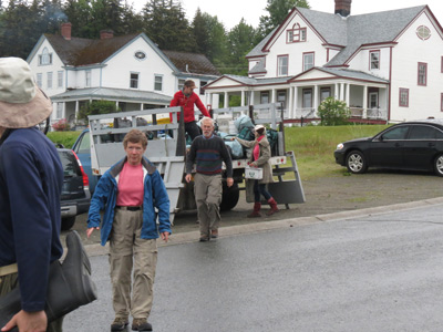
back to the hotel. The clients were bringing their gear down, and it
was all stacked in piles. One pile going on the Alsek, the other pile
headed back to Juneau. One large truck, with all the equipment (rafts,
food, and rafting gear) had already departed earlier, for the put in
point, about 160 miles to the NNW in the SW corner of the Yukon
Territory. Another truck would carry our gear (tents, sleep kits –
that consisted of our sleeping bags and full length Therma-rest pads
in a very stiff dry bag – and large dry bags with clothing, etc.) and
was getting packed currently. All but two of the clients would ride in
a large passenger van.
We awoke to gloomy, sodden skies at 5:45 am,
showered and dressed, and headed across the parade grounds to a little
coffee shop, SarahJ’s. Amalia, one of the clients, and Roger B. were
already there, and recommended the Yogurt Parfait, which was a nice
parfait with fresh fruit and granola. I wish I had taken a picture of
mine. We ate quickly, and naturally, it started to rain on the way
back to the hotel. The clients were bringing their gear down, and it
was all stacked in piles. One pile going on the Alsek, the other pile
headed back to Juneau. One large truck, with all the equipment (rafts,
food, and rafting gear) had already departed earlier, for the put in
point, about 160 miles to the NNW in the SW corner of the Yukon
Territory. Another truck would carry our gear (tents, sleep kits –
that consisted of our sleeping bags and full length Therma-rest pads
in a very stiff dry bag – and large dry bags with clothing, etc.) and
was getting packed currently. All but two of the clients would ride in
a large passenger van.
I guess at this point, it is worth introducing the players in this adventure.
Guides:
The chief guide was Sam Jansen. (He had been one of the guides on Sarah’s Alsek trip 10 years previously.) He does most of his work in Alaska and the Grand Canyon. He lives in Phoenix but is ready to get out of the heat and move to Flagstaff.
Joe Biby: A tall, strong guy from Kalispell, Montana. Used to live in Bozeman and taught first year med students, but did not enjoy the stress that came with the job. Now, he guides in the summer, and works with the Park Service in Glacier NP.
Kevin McDermott (aka Thirsty): Lives in Montrose, Colorado, does a lot of guiding in the summer on the Nenana River outside of Denali National Park. He’s in charge of snowmaking in the winter at Telluride ski area, and drives a winch cat there.
Clients:
David (aka DB): from San Francisco, a journalist with a lot of stories to tell. A LOT.
David’s son Thelonious, who, as DB described it, was conceived at the confluence of the Tatshenshini and Alsek Rivers, was 15, and attended school somewhere on the grounds of the Presidio in San Francisco. Very smart kid, but, I think, was a bit uncomfortable hanging around with a bunch of adults for a couple of weeks.
Roger B, our friend from Bozeman, former scientist and expert in nuclear weapons security, who used to work at Sandia National Lab. Known as a curmudgeon, he in fact is quite social and his knowledge is nothing short of encyclopedic.
MJ, Paul, and Jim are all scientists (albeit, with the exception of Paul, partly or mostly retired) from the National Oceanic and Atmospheric Administration – NOAA – in Boulder, CO). These guys have hiked, and backpacked extensively in Colorado and Utah, but less so other places. The only folks I have EVER met who had been in Moqui Canyon in Utah.
Scott is a professor of Rhetoric and now department chair at the University of Central Arkansas in Conway. Scott was the quietest fellow on the trip, but took some amazing photos. I had lots of good discussions with him concerning why it is so important for people to be able to communicate effectively via the written word.
Amalia is a burn surgeon with the University of Utah in Salt Lake, also having a specialty in dealing with frostbite injuries. She teaches, conducts research and has a clinical practice at well. She is, not surprisingly, both hyper-organized, astute, and speaks her mind. Very refreshing.
Sarah, our friend from Monmouth, Oregon, runs the Thermophile.org web site and is a professor of Microbiology at Western Oregon University. I have written about her in other places, so I will just point out she is super-accomplished and has a steel trap memory.
Susie, my spouse, is a former computer programmer (“like, why would you want to use anything but Notepad to code HTML…”) with the defense facilities and SAIC in Oak Ridge, TN. I have to be careful how I describe her, because obviously, I could go on for hours. Suffice it to say she is an accomplished hiker and backpacker, but that this was only her second river trip. Definitely not a water person.
Yours truly: Former scientist and group leader at Oak Ridge National Laboratory. Also a hiker and backpacker, and this was only my third real river trip.
So a typical client mix we were not. Way too many technical types for a “typical” rating. But typical or not, we were loaded up in the van (with the exception of Sarah and Amalia, who road with Jim???, the truck driver) and headed for Haines Junction, Yukon on a rainy morning. Our first stop was the US Border Control. Because we were re-entering the United states via an uncontrolled route (ie, the Alsek River as it leaves British Columbia and enters the US’s Glacier Bay National Park), we needed to provide our passports, which were checked, and enter our names on a sign in sheet. (After the trip was finished, Sam, as chief guide, was required to confirm that all clients and guides had re-entered the US as scheduled.). Our next stop was the Canadian Border Customs and Immigration. That did not take quite as long. Then we were off, back into the mist.
There was not much to see as we crossed Chilkat Pass, as the higher we got, the foggier the weather got. At this point, the Tatshenshini is flowing north, parallel to the highway. I have tried doing the Google Earth Street View virtual tour of the route, but the weather featured on that was not all that great. As we descended and crossed over the Yukon Border, we got below the clouds enough and stopped at a scenic overlook that had a view of the valley into which the Tatshenshini makes a big U-turn to the SW and leaves the vicinity of the highway. I suspect that this was near Dalton Post, the usual put-in spot for the Tat. One other attraction of this spot was the pit toilet.
From this point, it was less than 60 miles to Haines Junction. As we approached, the weather improved. We crossed the Dezadeash River just south of town, and, since the Dezadeash, tributary of the Alsek, is the river on to which we would start our trip, the obvious questions came up: why don’t we put in at this spot since it is so convenient. The answer from Sam, sitting on our bench seat, was that there is so little current in this part of the river, it would take us at least two days just to float to our put in spot. Indeed, the Dezadeash does do a fair amount of meandering over the several miles downstream of the highway bridge. Anyway, our next stop was the Village Bakery, which was lunch. Susie and I had been thru Haines Junction twice on our driving trip to Alaska in 2012 and had missed this spot, since it was off the main street by a couple of blocks. Too bad, because it was a very nice place, and highly recommended. While we were having lunch, Sam took off for the new Visitor’s Center for Kluane National Park (immediately south and west of town) to pick up and pay for our permit. It took forever, and he reported permit prices had risen to something like $500.
 It was not very far west of
town before we turned off the Alaska Hwy (having had to stop and
photograph a nice grizzly bear eating by the side of the road) and
headed south on a gravel road. We only went about 2/3 of a mile before
we stopped short of a stream crossing. This would be our “trailhead”
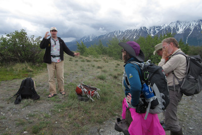
for the hike to the put in spot on the Dezadeash. Sam lectured us a
bit on bear safety in this country. I paid attention, because, even
though we live in bear country, it never hurts to be reminded. After
some communication breakdowns, which probably cost us a half hour, we
started hiking at 2:15 pm (Note that we used Alaska Daylight time the
whole trip, even though we were in the Pacific time zone for many more
days. I guess such was because the key times we had to know was when
we would be met at the take out point in 12 days or so.) Most folks
had their rubber boots on for the hike, because we were supposed to
have to cross several streams. Susie changed out to her regular hiking
boots after a few hundred yards. I never put my rubber boots on. The
hike was advertised to be something like 5.5 miles. I figured mentally
that we should be able to knock off the distance in maybe 2 hours and
15 minutes, given that we were hiking on a roadbed (albeit the creek
crossings were not suitable for a passenger van) and our packs were
light.
It was not very far west of
town before we turned off the Alaska Hwy (having had to stop and
photograph a nice grizzly bear eating by the side of the road) and
headed south on a gravel road. We only went about 2/3 of a mile before
we stopped short of a stream crossing. This would be our “trailhead”
for the hike to the put in spot on the Dezadeash. Sam lectured us a
bit on bear safety in this country. I paid attention, because, even
though we live in bear country, it never hurts to be reminded. After
some communication breakdowns, which probably cost us a half hour, we
started hiking at 2:15 pm (Note that we used Alaska Daylight time the
whole trip, even though we were in the Pacific time zone for many more
days. I guess such was because the key times we had to know was when
we would be met at the take out point in 12 days or so.) Most folks
had their rubber boots on for the hike, because we were supposed to
have to cross several streams. Susie changed out to her regular hiking
boots after a few hundred yards. I never put my rubber boots on. The
hike was advertised to be something like 5.5 miles. I figured mentally
that we should be able to knock off the distance in maybe 2 hours and
15 minutes, given that we were hiking on a roadbed (albeit the creek
crossings were not suitable for a passenger van) and our packs were
light.
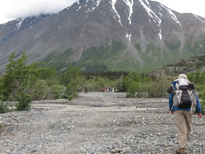 But time and distances can be deceiving. Out
here, the country side is so big that what looks like a mile or so can
be three miles. But also, it was clear that the weather was
deteriorating. Light rain had started and the wind was blowing
fiercely in our faces (ie, up river). We were hiking as fast as we
could, without stops except to photograph, my knee was killing me, and
the put in point seemed to be unreachable. Well, it took us 2 hours
and 45 minutes, so we arrived a few minutes after 5 pm. A final check
of the mileage on the route was, well, different than advertised.
According to GPS routing, it was 7.4 miles. So that was a healthy hike
for the afternoon.
But time and distances can be deceiving. Out
here, the country side is so big that what looks like a mile or so can
be three miles. But also, it was clear that the weather was
deteriorating. Light rain had started and the wind was blowing
fiercely in our faces (ie, up river). We were hiking as fast as we
could, without stops except to photograph, my knee was killing me, and
the put in point seemed to be unreachable. Well, it took us 2 hours
and 45 minutes, so we arrived a few minutes after 5 pm. A final check
of the mileage on the route was, well, different than advertised.
According to GPS routing, it was 7.4 miles. So that was a healthy hike
for the afternoon.
We were greeted by Joe and Thirsty, who had been working to re-inflate
the rafts and set up parts of camp. Given the lateness of the arrival
hour and the wind blowing upstream, the decision was made by the
guides that there was little point getting in the rafts and rowing for
a while. Later, I would learn how pointless it would have been.
Anyway, the first order of business was to find our tents (each in its
own dry bag, nicely labeled Roger and Suzanne) and get them set up. We
got a brief tutorial on how to set up the tents, but they were
Mountain Hardware Trango 3.1’s, and they set up virtually identically
to our Sierra Designs Stretch Dome. So no problem We took all of 5
minutes to get it erected and started hauling our gear from the pile
near the rafts. It was home sweet home in a few minutes. The Tat/Alsek
Guidebook refers to the put in spot as Serpentine Creek. For some
reason, I did not save the waypoint I took of this camp, but was able
to estimate it pretty closely with the help of Google Earth and some
other measurements I made. 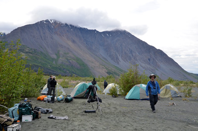 I
would call the camp position to be 8V, 350220 E, 6733863 N. (Note that
this is using the NAD 27 grid. There are lots of grids one can use,
but since we were going to be covering a lot of territory, and would
end up in the US, I thought NAD 27 would be fine. Anyone reading this
can do the conversions. I’ll use NAD27 grid and UTM coordinates for
all the waypoints.)
I
would call the camp position to be 8V, 350220 E, 6733863 N. (Note that
this is using the NAD 27 grid. There are lots of grids one can use,
but since we were going to be covering a lot of territory, and would
end up in the US, I thought NAD 27 would be fine. Anyone reading this
can do the conversions. I’ll use NAD27 grid and UTM coordinates for
all the waypoints.)
Next task was to erect the giant tarp. It felt like this tarp was at least 25 feet square. Huge. It took 7 or 8 people, all working together, but boy, it was worth the effort. Actually the rain had stopped – for a bit, so it was nice to have it even if we did not need it. The sun started to break through the holes in the clouds, and everyone’s spirits seem to be rising. Dinner was wonderful - baked halibut casserole, steamed broccoli, rice and salad. Susie and I may have had a sip or two of the Chambord….
Additional Photos and videos can be found here: The Alsek Days 1 - 4 album on our SmugMug Photo Album Site
You might enjoy reading a different perspective on this same trip: Sarah Boomer's Report on the Thermophile.org website
© Roger A. Jenkins & Suzanne A. McDonald, 2014, 2016