Bailey Range 1996
Scott-Ludden Saddle to Dodger Lakes
Our planned day was pretty short, about 3.5 miles, most on-trail (finally, thank god). We had one more obstacle to cross: the descent from the saddle, and the steep climb up to the end of the abandoned trail from Dodger Point. I figured that it would take us 2.5 - 3 hours to cross this half-mile-from-hell. We tried to dry our gear in the improving sunshine, but the clouds to the east were persistent, and never really gave us full sun.
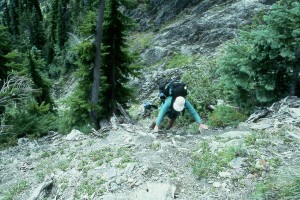 There is an obvious path out of the saddle, and it is really worth the effort to stay on the path. There are a couple of false paths that
one can follow, but they just lead to more difficult routes. We dropped steeply about 200 feet through thick vegetation, and then
began an ascending traverse. I took my pack off to scout the route, and finally came to the crux: one has to drop about 15 feet on
a wall: rock climbing with a backpack again, to gain the floor of a small gully which leads up to the climb out point. I went back,
got the rest of the crew, and volunteered to be the first. Basically, you have to hold on to tree branches with both hands and swing
out over the face to get a better foot hold. It is less dramatic than it sounds, but I heard a lot of guffawing about Tarzan of the Bailey
Range. All of us made the gully floor without mishap, although wrenched my right shoulder a bit. The ascent out of the gully to
the abandoned trail is difficult because it is so steep and there are lots of loose rocks. But basically, once in the floor, the route up
is easy to find, IF you pay attention. Will took the lead, because of his experience at rock climbing: that was fine with me. But he
ended up taking a more difficult line, and Susie shot ahead. It is probably 150 feet of climbing. Susie got ahead of me by about
30 feet, and she called down to me that she was to an area that was a little flatter. I yelled back that she may be to the trail. I could
see the delight in her eyes when she surveyed her surroundings, and realized that she did not have to go up any more. Will followed
me by a minute or two, and Regina and Dolph were right behind: 2 hours and 20 minutes to go what ends up being about 900 meters
of linear distance. We all whooped and hollered, secure in the knowledge that we were now very likely to survive this trip.
There is an obvious path out of the saddle, and it is really worth the effort to stay on the path. There are a couple of false paths that
one can follow, but they just lead to more difficult routes. We dropped steeply about 200 feet through thick vegetation, and then
began an ascending traverse. I took my pack off to scout the route, and finally came to the crux: one has to drop about 15 feet on
a wall: rock climbing with a backpack again, to gain the floor of a small gully which leads up to the climb out point. I went back,
got the rest of the crew, and volunteered to be the first. Basically, you have to hold on to tree branches with both hands and swing
out over the face to get a better foot hold. It is less dramatic than it sounds, but I heard a lot of guffawing about Tarzan of the Bailey
Range. All of us made the gully floor without mishap, although wrenched my right shoulder a bit. The ascent out of the gully to
the abandoned trail is difficult because it is so steep and there are lots of loose rocks. But basically, once in the floor, the route up
is easy to find, IF you pay attention. Will took the lead, because of his experience at rock climbing: that was fine with me. But he
ended up taking a more difficult line, and Susie shot ahead. It is probably 150 feet of climbing. Susie got ahead of me by about
30 feet, and she called down to me that she was to an area that was a little flatter. I yelled back that she may be to the trail. I could
see the delight in her eyes when she surveyed her surroundings, and realized that she did not have to go up any more. Will followed
me by a minute or two, and Regina and Dolph were right behind: 2 hours and 20 minutes to go what ends up being about 900 meters
of linear distance. We all whooped and hollered, secure in the knowledge that we were now very likely to survive this trip.
We took a long lunch break at the top, which is really the place where the CCC stopped blasting out a shelf along the cliffs of the
east face of Ludden Peak. Susie and I drunk in the views of Cameron Pass, the Elwha valley, the edge of 1000 Acre Meadows, and
reminisced about the trip we had done together (married to others) back in '84. The weather was improving, and we felt like we
had it made. 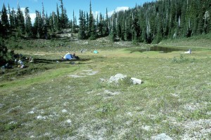 We hoisted our packs and headed for Dodger Point on the abandoned trail. There were a few places where it was
washed away down the cliffs, but compared to what we had done the last few days, it all seemed like a piece of cake. We got to
Dodger Lakes, a little depression with a couple of tarns in it and a small creek, set up camp, and relaxed in the sunshine that was
now nearly full. It was wonderful knowing that the remaining 12 miles to Whiskey Bend should be uneventful trail walking. I
found a pond where the water was especially warm, and cleaned myself up, relishing every drop of warm water. We walked over
to some of the open areas to drink in the views: the back side of the Bailey Range all the way to the Strait of Juan de Fuca. Every
one seemed in the mood for an early dinner, so with the chill in the air, and a cold nite on the way, we cooked, did the obligatory
shuttle car key transfer ceremony to those running the shuttle that had to leave extra early (Susie and I), and headed for bed. I think most of us were completely in tentia by 7:45 pm.
We hoisted our packs and headed for Dodger Point on the abandoned trail. There were a few places where it was
washed away down the cliffs, but compared to what we had done the last few days, it all seemed like a piece of cake. We got to
Dodger Lakes, a little depression with a couple of tarns in it and a small creek, set up camp, and relaxed in the sunshine that was
now nearly full. It was wonderful knowing that the remaining 12 miles to Whiskey Bend should be uneventful trail walking. I
found a pond where the water was especially warm, and cleaned myself up, relishing every drop of warm water. We walked over
to some of the open areas to drink in the views: the back side of the Bailey Range all the way to the Strait of Juan de Fuca. Every
one seemed in the mood for an early dinner, so with the chill in the air, and a cold nite on the way, we cooked, did the obligatory
shuttle car key transfer ceremony to those running the shuttle that had to leave extra early (Susie and I), and headed for bed. I think most of us were completely in tentia by 7:45 pm.
© Roger A. Jenkins, 1996