Beartooths Backpack 2002
The Best Laid Plans...
The rescue begins
Wednesday, September 4
 Another frosty morning, and we were up before 7 am. I poked my head outside the tent, and could see Sue trying to stand up and put weight on her left leg. It was NOT a pretty sight. (Given her response, I had become convinced that her ankle was broken.) There had been no overnight miracles, and I knew what four of us would be doing today. We gathered for breakfast and talked, but there was very little deciding to do. We took down the smaller of the two tarps, not so much because we would need it, but rather to lighten whomever's load would have to hike out with it. Susie loaned Sue her ThermaRest adapter, so she could convert her sleeping pad into a chair, and at least get some back support. There were hugs and handshakes all around, and general wishes of good luck. I decided I liked being in the crew that was in control. I figured it must be funny to realize that you might be spending the next 2 - 4 days just sorta hanging out, waiting for someone to get you. And then the four of us were off. Despite the remnants of my cold, I did not feel too beat that morning. We all knew that we had a potentially long, hard day ahead of us. This was not about sightseeing or wilderness enjoyment, it was about getting out and fixing a problem. The mood was not grim, but it was deliberate.
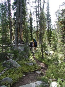
 We pulled out of camp just a couple of minutes after 9 am. Our first task was to move the 1.5 miles or so to the nearest trail, which most hiking guides refer to as Muddy Creek. The point nearest that was at the northwest corner of Lake Elaine. So we headed on a fisherman path up through the saddle that is on the NW corner of Green Lake. I recall from 17 years ago, the movin' was easy, and there was nothing to dissuade me this time. I did remember the150 meters or so of talus blocks that need to be negotiated to go along the north side of Lake Elaine. It was slow going, and Tim went back to guide Diane (the ONLY time on the trip that I ever passed Diane) as she dislikes the boulders (I don't much care for them myself). It gave me the opportunity to rest, for which I am always grateful. As we picked up the end of the Muddy Creek trail at the NW corner of the lake, you could look out to the exit end of the lake, and it looked like the lake would just pour off the end of the world. There were no trees down there, just air. I figured it must be a helluva drop off.
And it was. If you look closely at the topo map leading south from Lake Elaine, you will note that there are several contour lines that the trail crosses. It drops at a rate of 1400 feet per mile. Whew. It was hard not to slide down. But it only goes on for a couple of hundred feet, but it took us a while to get to the bottom. We crossed the creek, and took a rest break, while Tim went to commune with nature. Soon after we started a vastly more gentle descent toward Granite Lake, we met a nice young couple from Chicago.  Talk about packs. The fellow had the identical pack to mine (‘97 Gregory Denali Pro) but his made mine look empty. They were out for two weeks, and with that load of food, were moving short distances each day that they were not based camped. (Young couple from Chicago: If you are reading this, let us know who you are and we will send you back your map.). It was mostly gentle descending through woods that got us to the NW end of Granite Lake. Tim was obviously suffering: he realized that he had left their entire supply of toilet paper back in the bushes at the last camp. And he had to go again. Fortunately, I always keep a good supply with me, and was happy to share. Especially with someone in such distress. It was about 12:15, so it was a good time to stop and eat lunch. If I could have done what I wanted, I was ready to stop for the day. My energy reserves had gone south, without taking me with them. But we still had a long long way to go. And a decision to make. In some ways, the route around the north shore of Granite Lake seemed shorter. But Chicago had warned us about the crossings of the inlet streams, of which there were many. A closer look at the topo map indicated that the route on the east side of the Lake, ultimately re-joining the Muddy Creek Trail, gained several hundred feel. The trail on the west side of Granite Lake seemed to only gain a couple hundred feet, and might have been a tad shorter. The way I was starting to feel, it was not much of a decision.
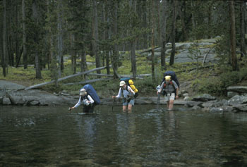
 After lunch, it turned out that the trail does only climb a couple of hundred feet, but that is after it does a lot of up and down. It was obviously distressing me, and Susie waited patiently for me at the top of each uphill pull. After a while, it started to drive me nuts, as I just wanted to suffer in my own private hell. I told her so, and that was taken as not being appreciative. As they say, it is all about communication. Anyway, another 65 minutes of trudging brought us to a trail junction at the SW corner of the lake. It looked like another storm was brewing, so on went the rain gear and pack covers. But by the time we had finished our rest stop, the darkest clouds had blown over and so off came the rain gear. We turned east and headed for the outlet of Granite Lake, arriving at aptly named Lake Creek around 3 pm. Aptly named, because the creek is more like a lake. Susie quickly doffed her boots, changed into her camp shoes, and immediately went in up to her crotch. I don't think any of us were expecting such a deep ford, but it did give us a chance to wash off the grime of the day, and rest a bit. I would imagine that in all but the low water times of the year, this ford is all but impassable. The hiking guide calls it the most dangerous ford in the Beartooths, and I can see why. If the water were any deeper and faster, you could not stand on the bottom.
On the east side of the ford, there is a myriad of trails going every which way, and no trail signs. Since we knew we had to go down the drainage to the big marsh south of Granite for our night's camp, it was easy to pick the correct route, merely by following the topography to the SE corner of the lake. We arrived at the turning point, where the Muddy Creek trail heads south, at 3:35 pm. Two hours and 40 minutes to circumnavigate Granite Lake. It is big, for sure. We all shook our heads as to how the couple we met on the second day could have "lost" the lake. But enough with the reminiscing. We had hiking to do. About a couple more miles of it, at least. So more trudging. I even detected that maybe T&D were getting a little tired. Just a little. The trail down the drainage is downhill, but not as steep as that coming out of Lake Elaine. Just down, and down, except for the ups. At one up, not too far from the bottom, Susie took off her pack, and threw it on the ground, in frustration with all of the uphills on what should have been a downhill day. Either that, or it was just her way of signaling that she needed a rest. So we all took a brief break, and then headed on down for the trail along the edge of the marsh. Did I say edge?? We quickly learned why they call this the Muddy Creek trail. Frankly, the trail just disappears. The grass has been bent over a bit, probably by some moose that passed through a few weeks ago. Either we had lost the trail, or that is the way it is (a post-trip reading of the hiking guide suggests the latter is the case). It was hard to tell if we were wading or walking. The water was just below our boot tops, and I could surmise that for Susie, it was over the tops. Tim was not too far ahead of me, and he muttered "The things we do for our friends!" It just was not a very pleasant way to end a tough day. Of course, there was that little thing about finding a dry place to camp. Tim and I stopped and reconnoitered the terrain. About a quarter mile from where we were standing, it looked like there might be some open higher ground. We had to get out of this marsh.
Eventually, the trail went back into the woods, and we were able to keep our feet dry. We got to the first flat area, near some trees at the edge of the marsh, near were a small inlet stream was flowing. Boy, I thought to my self, this is absolutely prime grizzly bear habitat. As Susie and Diane looked for a suitable place to camp, I could hear Susie complaining already about the bugs, and I was standing there, I got a few bites myself. Then I heard someone exclaim about the size of the pile of bear scat that they had found. I never saw it, but it was clear that we would not be camping THERE for the night.
 We moved about 200 meters downmarsh (hate to use the term downstream, since that would imply we knew there was flowing water out there, although there clearly had to be) and found a spot that was on the uphill side of some trees at the edge of the marsh and within sight of the trail junction. It was just after 5 pm - 8 hours of heavy duty hiking and I was one tired puppy. I think even Tim and Diane were ready to quit for the day. Of course, if it had been a matter of time, we could have kept on hiking, but we felt like Sue was OK where she was, and that we did not need to hurry. I looked around and started to have a very bad feeling: the ground was dug up everywhere I looked. I was afraid we were in a spot where the grizzlies had been digging for ground squirrels. I can recall the hair going up on the back of my neck, until I started examining the dirt piles. I have seen true grizzly diggings before, where they just stick their paws into the dirt and rip up the turf. Closer inspection of the piles revealed that the dirt was all in very fine clumps. Not likely from grizzlies, so I convinced myself that these were ground squirrel mounds, but I must confess, there must have been thousands of those critters devoting their lives to digging at the edge of this huge meadow. We got camp set up, and Susie and I took off to get cleaned up at the nearest stream. The water was vastly colder than lake water, and I became convinced that there must be a glacier somewhere in the near vicinity.
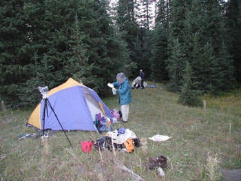 We found an old fire ring with a couple of downed logs about 50 meters from camp, on the other side of the trees from where we actually had our tents set up, and it looked like a good place for dinner. Susie had crafted this new dish based on Orzo and freeze dried chicken and peas. I had insisted on putting in the spices, to make sure it packed enough punch, and it turned out to be pretty good. In the conversation with Tim after dinner, the talk inevitably turned to: what if we had a satellite phone with us? Would that have improved our situation? I have been death on such things. I believe that if people have them, especially inexperienced people, there may be a tendency to rely on them too much, and not be as careful as one might. There is also the purist in me that just doesn't want that much high tech in the wilderness. People have asked me: "Well, what is the difference between a satellite phone and GPS?" The difference, of course, is huge: GPS units are merely receivers. You have to decide what to do with the information, and you need some skill just to use it. A satellite phone, in contrast, is a two-way communication device, basically a wilderness cell phone. I know that some friends have used them to call kids back home "just to check on things." I find such appalling, since for me, it violates one of the vital aspects of wilderness travel: being cut off from others. I say, if you can't trust the kids to behave while you are gone, having a satellite phone is not really going to help the situation. Maybe you or they are really not mentally prepared for you to go off. Of course, there are many opinions, and mine is not the only "correct" one. Tim had a different slant. His distilled down to something like this: Look, this is my vacation. I really hate that my vacation has been "restructured" and truncated due to the injury of one person, even though Sue is a very important person to me. If we had a satellite phone with us, I don't give a damn about calling anyone to talk. But we could have arranged for a rescue by phone, and then the rest of us could have gone on with our trip more or less as planned. In some ways, it is like trip insurance that you can get for many of these guided trips. It is an idea worth pondering. I wonder though, if that first afternoon, we could have arranged for a rescue and left Andy and Lance back there and really continued on with our planned backpack. I am not sure we could really do that. I do think that for this particular bunch, there is little interest in calling back home. Only three of us have kids, and we are a pretty experienced bunch. I think I had the least number of years (not necessarily trips) of backpacking under my belt, and I have been doing it for 25 years.
Anyway, we hung our food upmarsh from our tents, and crawled into bed around 8 pm. The sun had barely set, but we were tired, and we knew we had a big day tomorrow.
© Roger A. Jenkins, Suzanne A. McDonald, 2002