Royal Basin/Constance Pass - 1990
Solo Adventure in the Olympics
Rough descent
Thursday, September 6
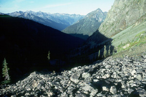 Lying in my tent last night, I had pretty much made up my mind that to attempt any route other than going down Deception Creek XC would be foolhardy. Yesterday had been enough exposure for one trip, and it seemed like the trip down the creek would be an adequate level of challenge. I was underway pretty quickly, leaving camp at 7:55 am. As I got to the point where the Creek drops out of the basin, I looked for the supposed path mentioned in the Climber's Guide, but could find nothing that resembled any organized route. So I took off to the right of the creek, staying in open terrain as long as practical. The first 500 feet of descent s pretty interesting: hopping across these small boulders. Very unstable. After a bit, I realized that I was not losing as much elevation as the creek, which meant that I would have to start descending steeply through the boulders. Boy, was that fun. I kept thinking that it would be really easy to twist an ankle in this stuff. However, I knew that the longer I stayed in the talus, the less time I would have to fight alder in the creek bed.
The alder that grow in the Pacific Northwest I liken to the rhododendron that grow in the eastern mountains: they can both be hell to backpack through. I had put away my camera and tripod, but kept my ice axe out for stability through the talus. In the alder along the creek, I could have used another set of both hands and feet. Part of the challenge of off trail hiking through this stuff is ultra low visibility. Often, you can not see more than a few feet in front of your face. Couple that with the poor footing and pretzel-twisting your body must endure to snake your way through the alder thickets, and you come up with a pretty tiring experience. I stayed within earshot of the creek as I pressed forward. It seemed like I could hardly find a place to stand up straight without an alder branch forcing me to bend over. In late morning, I forced my way over to the creek to get some water. I got out on a rock that was at the edge of the creek, to give myself a bit more vertical clearance. I looked down, and saw a rusted tin can. I don't know why I was so happy to see it, but I felt at least some other semi-crazy souls had done the same thing as I was trying to do. (It did not occur to me until several hours later that the can could have been washed down from the basin in a storm.) I plunged back into the thickets with renewed enthusiasm, cursing a string of epithets that would make a sailor blush. I don't think I have sworn so much since I tried to pound plastic tent stakes into the ground in the Chisos Mountains in Big Bend National Park in 1974. I remember that my first wife got so aggravated that she took a walk instead of helping me set up our tent.
One of the advantages at having experience with off-trail hiking in places like the Smokies is that you soon learn to get a "feel" for the terrain, and how one might move through it on the trajectory which requires the smallest energy expenditure. The animals have this sense, because they live in the woods all the time. Having started my hiking career on trails, I can assure you that on-trail hiking prepares one only minimally for off-trail experiences. The Smokies are a good place to learn the off-trail craft, because if you can do it there, you can do it in any mountains out west. It is hard to describe this "feel," but there is no doubt that one develops a nearly intuitive sense. So when my intuition told me to leave the near vicinity of the creek as it got into heavier timber, I followed the call. 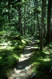 Before long, I picked up what I thought might be the long-sought "path" down the creek. About noon, at an elevation of 4200 feet, in a little clearing, I picked up a path. I noticed some markers on trees, but they soon disappeared, as did the clear path. But after a bit, I started to pick up a route, a way which would disappear and reappear. Again, it was nothing definite, just slightly more compact earth under the boots, a broken branch or two, a worn spot on a log. Sure, there were lots of blowdowns, but with every hundred meters, the path seemed to intensify. We are not talking trail here, just a way through the woods.
About 2 pm, I noted that my right hand was swollen from the pounding the head of the ice axe was giving it, and my feet felt like hamburger. But I was moving down, and knew I would get to the trail before long. At 2:35 pm, 6 hours and 40 minutes after starting, I got to the Dosewallips Trail. I was so happy, I bent down and kissed the ground. I was done with the off trail portion of my trip. My fun meter had been pegged. My goal now was to get to the Constance Pass Trail, but I was really tired. I moved the down the river trail as fast as I could go, but after about 4 miles along the river, I came to a nice spot near where Slide Creek crosses the trail. It was small, but it was flat and it was here. There had been very few spots to comfortably camp in the last few miles, so I was not taking any chances. It was pushing 5 o'clock, and it was time to quit for the day. I pitched my tent, had some freeze dried food for dinner, washed up the dishes, and hit the sack by 8 pm. I was exhausted.
© Roger A. Jenkins, 2000, 2006