Sierras 1986
Sequoia's Eastern Boundary
Out of the high country
Friday, September 5
 Wow, what a good night's (and part of an afternoon's) sleep will do to fight off the virus that had plagued me. I felt substantially better this morning, no longer having the body aches that had bothered me the last three days. Sure, my lungs were still congested, but it is a tribute to the human body that you can abuse it, by hiking with a 60 lb pack on your back, instead of sleeping, and it still can fight off the bugs. Our goal today was Anvil Camp, on the eastern side of the escarpment. To get there, we would exit Wright Lakes Basin to the north, across a saddle at UTM 11S, 378,037 Easting, 4056,367 Northing, and cut to the northeast, picking up the trail coming over Shepherd Pass, and drop on down the Shepherd Pass Trail to Anvil Camp. It is about 3.8 miles or so to Shepherd Pass from where we were camped, and less than 2.5 miles down to Anvil Camp, which is just above 10,000 feet.
I think I was feeling so good that climbing "only" 900 feet off trail seemed not too bad. Of course, I could not see exactly where we would be hiking, so hope springs eternal in the human breast. We had a relatively leisurely morning, although George was ready to go far before us. I think we all were savoring our last morning above timberline. We watched George in the distance, and his approach seemed pretty straightforward: just follow your nose to the saddle, staying on the lowest possible energy trajectory. It was pretty easy moving through the "lowlands," akin to walking across your lawn with a few large boulders scattered around. But eventually, it was time to go for the saddle, and the easiest approach seemed to be to hug the slope to the east, gradually gaining a good chunk of the elevation between camp and the saddle. The slope itself was not too difficult, as it was comprised of rocks and grass, not loose talus. We would stop every so often to catch our breath, and take photos of Mt. Whitney from the north. This is perhaps one of the more interesting views of the peak, as you can see how gradually sloped the west side is, and how abrupt an escarpment the east side is.
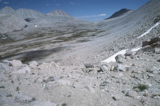 We got to the saddle, and could look out over the terrain to the north and immediate east, and it did seem other-worldly: not a tree is sight, just scattered grass, and gray granite (I think that is what it is, but I am no geologist. I keep meaning to take a beginning geology course, and one day, I definitely will.) While the country is pretty stark in this extreme northeast corner of Sequoia National Park, it is also gentle, and on a sunny day, it seems park-like and non-threatening. We did a quick spin around, and could see no other humans, although we could spot the John Muir Trail heading toward 13,000+ ft Forester Pass. This is the Sierra High Country, for sure. But we couldn't stay forever, instead making the mental promise to return some day. We decided from this point to lose no more elevation than we had to, so instead of heading directly to the closest point of the Shepherd Pass Trail, directly to our north, we would traverse the slope to the northeast. The terrain seemed so gentle, so we skirted the area on the topo map that is marked as marsh just to its south, and actually hit the trail a little more than 3/4 mile SW of the Pass. It seemed like a great place to stop and have lunch, especially since passes are notorious for their lunch-shortening breezes. Life was good, I was feeling much better, and even though we were getting ready to leave the high country, on this, the last full day of our trip, we knew it was pretty much all downhill from here.
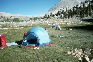
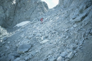
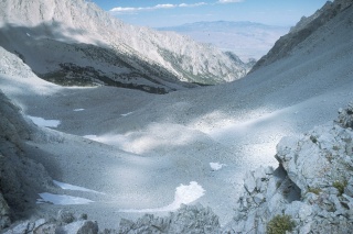 In a big way for sure. When we got to the actual pass, our overwhelming impression was: This is the trail??!! We knew that the eastern escarpment of the Sierras is much steeper than coming through the gentle foothills from the west, and that Shepherd Pass is supposed to be the most difficult trailed pass in the Sierras, but it is one thing to "know it" and something completely different to have it staring you in the face. As you stand at the pass, it feels like the bottom has dropped out of the earth, at least for the next few thousand feet. There is a sign confirming that this is, in fact, the place you thought it was, but the "trail" dropping out of the pass looks more like something a few mountain goats would make on their way to greener grass than anything done by humans. The track itself is through sand and gravel, and we could see that there might be a bit of snow to cross. But compared to some of the other stuff we had done, it looked steep but do-able, so we plowed ahead. Gingerly. In fact, it took us a good half hour or so to drop the half mile (and really only 700 feet or so) to the point where the slope decreases to a moderate grade. It turns out that several parties had been this way since the last snow, and had worn a nice path down to the earth: no snow descent to do on this day. By the time we had dropped to 11,000 feet, we were starting to pick up some scattered trees and grass. After a well deserved rest (at least we thought so), it was hoist and head for Anvil Camp. The write ups concerning this spot were seductive, given the starkness of the terrain we had be traveling through the last couple of hours. We were not too concerned that we would have to share the site, as it was clear this was not a heavily traveled part of the John Muir Wilderness. Indeed, as we pulled into Anvil Camp, while it was not exactly Shangri La, it did have a nice creek and some trees. It was the first time we had camped "in the woods" on the entire trip. I must admit I felt a little hemmed in.
 Sunny and I cleaned up near the creek, feeling good to get all the dust off our legs. After so much hiking in the Smokies, where the trails are damp to muddy, it is always a little strange to find your legs covered with fine dirt, stirred up from hiking the dry trails. We chatted about the arrangements for tomorrow, and hoped that Earl had indeed been successful at finding his way out safely. He had promised to take George back to LA for his flight home, while Sunny and I would head for Death Valley. She wanted to be able to say she had gone from the highest point in the lower 48 to the lowest spot in just a few days. I figured it would be pretty hot in the Valley (it would be "only" 117 degrees when we pulled in on Saturday afternoon), but the contrast between the high mountains and the desert would be interesting. The three of us wanted to get an early start in the morning, mainly because we had a ways to go, and also, we knew as we dropped in elevation, things would warm up during the day pretty well.
© Roger A. Jenkins, 1986, 2001