"Iffy" on the Continental Divide: Return to Colorado's Weminuche
A real test of the new tent
Thursday, September 22 In between the rain storms during the night, we could hear elk bugling. I guess it is just that time of year. Probably the worst storm was around 2 am. Lots and lots of hard rain. I was hopeful when I got up to take a leak at 5 am, because I could see moon light. Well, that did not last too long. All four of us were up a little after first light. On the side of the ridge about a half mile SW of us, we could see a bull elk trying to keep his harem of five ladies under control. Most likely an impossible task. The weather? Well, it was not too promising. Heavy dark clouds penetrated by the occasional blue sucker hole. I figured it would not be too long before showers were upon us yet again.
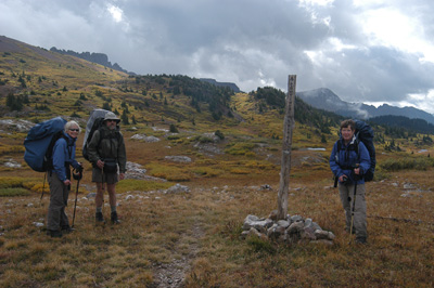 We were all outta camp by 8:50 am, and our first task was to find the Continental Divide trail. The trail is supposed to be going just to the northeast of Twin Lakes, but we sure couldn't find it. The fact that finding the trail is so challenging for four backpackers that collectively, have over 100 years of backpacking experience among them, says something. Maybe we were just getting old, but frankly, a more reasonable explanation is that the trail itself is faint to non-existent. Now the "route" is not too hard to figure out. You sorta look at the terrain, and ask: what would be the easiest way to cross this. Indeed, we eventually picked up the official CD Trail, as it begins, from the west, to round the north side of 12,000+ foot knob just to the SW of Ute Lake.
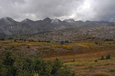 After Ute Lake, the CDT begins to climb steadily. Not really steeply, but steadily to the southeast. Our goal was Gunsight Pass. Realizing you are officially at Gunsight Pass can be a challenge coming from the direction we were. As near as I could determine, Gunsight Pass is in a bit of an opening immediately southeast of a small knob marked 12,444 (286,113E, 4167884N). At first, we were not sure that we were at the pass. Then, we all started to move forward and I realized that Tim and Diane, in front of us, were starting to descend. I knew that was the wrong way, because the description of the CDT indicates it slabs around to the north and constant elevation, more or less until it starts to descend to the saddle at 12,043 feet (287,647 E, 4169,459 North). So we went back and tried to figure things out. I took a GPS reading to confirm (or perhaps, figure out) our location. While I was doing so, I looked down on the ground, and saw that a piece of heavily weathered wood lying on the ground was in fact, if you looked carefully, a CDT sign. So much for good signage, and additional justification for carrying a GPS. All this frogging around had cost us precious time. Not that we were in a hurry, but it was clear that the weather was not improving. By the time we left Gunsight Pass, it was 11 am.
This particular route has a lot of history with me. Back in 1981, my previous spouse, Sunny, and I were backpacking along this route. The second day of the trip, we had departed Weminuche Pass and tried to make it to Ute Lake. What a day: heavy packs, altitude sickness and disorientation and thunderstorms slammed us all at once. I recall standing in the middle of the trail that we were about to traverse, just under the crest of the ridge, with a late afternoon thunderstorm raging around us. I stopped and simply could not figure out where the trail was. That was scary, since I was standing on it. I recall practically crawling the last mile to Ute Lake, or at least to the shelf above it. I was so tired I had to stop less than 200 meters from the spot we could see we wanted to camp at, simply to regain sufficient energy to make it that last 1/8th of mile. Pretty sad for someone in his mid-30's. That had been a very rough day.
We made pretty good time in the long, descending traverse to the aforementioned saddle, taking just about an hour to make the two miles. We all wanted a leisurely lunch, but reality set in, along with the forerunner of another storm, so lunch was a 15 minute wolf-down. We departed in spitting rain. The maps show a long switchback on the climb out of saddle to the east, but if that switchback is there, we did not notice it. (An observation about the trail locations, maps, etc in this area. It seemed to us that while many of these trails are easily followed, especially the ones in the valleys, many of the high country trails are a work in progress, especially the CDT. I would rely on the routes on maps only for general guidance. Someday, when Google Earth has higher resolution photos of this area, it would likely be worthwhile to study the aerial/satellite photos of the area in which you will be hiking, and maybe even translating the trail photos on to your maps. In the meantime, it would be great if someone trying to, for example, hike all the trails in the Weminuche Wilderness, could hike with a GPS unit's tracking feature turned on and do accurate mapping of the trails. In the meantime, take trail locations with a pound of salt.)
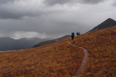 The climb up out of the saddle is fairly steep for the first 400 feet and takes a bit of time. But it too passes, and the grade slacks off about a kilometer SW of the next saddle (marked 12, 617) and becomes a climbing traverse. We felt pretty exposed, especially with thunder audible to our northwest. OK, it was more than audible: I found myself counting the seconds between the flashes and the booms. The sky was pretty threatening, and I kept thinking to myself, you know, you would think I would not be plagued with the same sort of thunderstorms, hiking in a different season, at a different time of day, than I was 24 years ago. Alas, some things never change. Anyway, it took us 45 minutes to make the saddle, which we did with wind, sleet, and threatening thunder (but the lightning never got closer than a mile or so). Motivated by the weather, we made it to what the guidebooks call this little pond below the Window as Opal Lake. As seems to be the pattern, the maps do not show the trail correctly. In fact, the CDT descends and makes a slight turn to the NW, coming alongside the east side of Opal Lake. On the descent, we met the first human we had seen since leaving the trailhead: a single guy who was doing a big loop out of the Pine River. After we moved on, Susie looked up at the sky and said: I hope he has a big book with him.
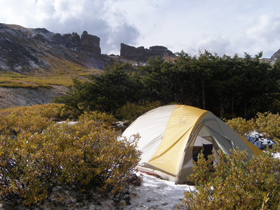 We arrived at Opal Lake maybe 30 - 40 minutes after we left the previous saddle. There was not a lot of great camping, but we did find a couple of flat spots on which to erect tents (289702 E, 4171243N). It seemed a bit early to stop hiking, but a) we were unsure of any good camping or water in the next mile or two, and b) with the weather deteriorating even further, well, it looked like a great time to call it a day. We hurriedly erected our tent, with Tim and Diane being on a tiny knoll maybe 50 meters south of us. We just finished getting the tent up and it started precipitating heavily. We realized that it was no longer rain or sleet, but what I used to call popcorn snow. In Montana, the "official" word is "graupel" for this stuff. It snowed pretty hard for 20 minutes and then the sky lightened, so we stuck our head out and looked around some more. Yep, it had snowed, and we could see another storm cloud on the way. This time, the weather was serious. Thunder, lightning, and snow. Many of the lightning pulses were within a thousand feet. Tim reported that he had gone down to the lake to get some water, and a lightning bolt hit so close to him that he could smell the ozone. Way too close for safety. Basically, we spent the afternoon trying to stay dry and semi-warm in the tents, absorbing wave upon wave of thundersnow. During one break, we decided to set up the fly, so that it would be easier to cook. Our site selection mandated we would sit on snow, but with foam pads, even that was not too bad.
About 5:30, we decided that there was enough of a break to cook dinner. Dinner was some chipolte rice with dried ham, which was not too bad. Diane and Tim graciously shared some of their remaining wine with us. It added a nice touch to an otherwise yucky day. We retreated to the tents pretty early, like 7 pm. I looked out again, right before dark, and it seemed like there was a bit of blue sky. Sucker hole, or impending good weather? Only another night in the tent would tell us. At least we were warm and dry. Clean? Well, maybe a little.
Additional Photos of this trip can be found here: The Weminuche Wilderness 2005 on our SmugMug Photo Album Site
© Roger A. Jenkins, Suzanne A. McDonald, 2005, 2007, 2017