
Grand Canyon 1998
Getting started
Today was just about as much fun as I can stand. I don't care if it is on trail or off trail, 4800 feet of descent on rocks is a long way to drop. I realize that the day that I summited Mt. Ranier, I descended more that 8000 ft, but virtually all of the elevation loss was on nice soft snow, and I was hurting that day too.
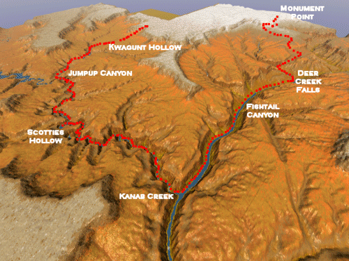
To begin at the beginning, we left Kanab, Utah about 6:30 am MDT (which became official trip time, even though Arizona is on MST. We did that to make Will feel as though he did not have to get up so early. He has this "thing" about getting up early. For someone like myself who is a morning person, and arises each day at 5:30 or so, it is no big deal.) Anyway, the trip to the trailhead was slow, because the Forest Service ranger had indicated that Road 422 was blocked with snow on the plateau, and that we would have to use the low elevation alternative, Road 423/427. Boy, was that a mess: heavily rutted and really twisty. We put the 4 wheel drive at the Sowats Point trailhead, and then headed for Monument Point. We had been told that the past Monday, the snow was so bad that someone had tried to drive out to the point thru the snow, and got stuck. Fortunately, we had high clearance vehicles (no accident: I had deliberately kept the big van and had rented a 4WD for the shuttle vehicle, just for this eventuality), and were able to get thru the offending snow patches out to the Bill Hall trailhead. We noted however, that every vehicle at the trailhead was a high clearance vehicle. Mostly trucks and 4WDs. We arrived at ca. 9:30 am MDT, and took the usual half hour to get our act together. I don't know why we all need that much time at the trailhead before we start a major hike, but 30 minutes is pretty much par for the course.
The famous Bill Hall Trail drops off Monument Point like a rock, 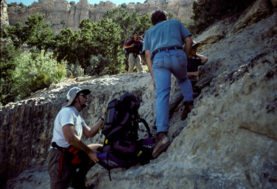 descending several hundred feet quickly. I had
known this was to be long, tough day, so was mentally prepared. I am not sure you can ever get physically prepared.
The trail is easy to follow, and turns NW, just like the topo maps show. At the top of the 49 switchbacks, there is this
thing that I was really concerned about: the 20 foot cliff. Folks had talked about it being difficult, and others had
barely mentioned it. When I got to it (Andy, Lance and Sue were ahead of me, as usual), they were already down. It
is not a cliff, just a short discontinuity in the trail. You can easily take off your pack: some of us did and some did not,
and hand it down or slide it down. Definitely no need to carry a 50 foot, 2 lb. rope for the effort. We were past that
by 11:30 or so, and continued down the switchbacks. The trail levels out after a half an hour or so, and by noon, I was
munching some lunch under the shade of a cedar tree. Barbara and Will went on down to find some more shade, and
Sue and Andy and Lanced did not stay long. I eventually caught up to the latter, and kinda walked along the
Esplanade with them for a while. Of course, they quickly moved out front, and I was envious of their ability to move
quickly. As I cut around the last drainage (4,030,500 N, 369,150 E), I noticed a small spring just to the right of the
trail. Manna from heaven!! I figured it would not hurt to tank up. I had started with 3 L of water, and had drank as
much as I could hold, but I drank a pint from the spring, and put another pint in my water bottle. I am glad I did.
descending several hundred feet quickly. I had
known this was to be long, tough day, so was mentally prepared. I am not sure you can ever get physically prepared.
The trail is easy to follow, and turns NW, just like the topo maps show. At the top of the 49 switchbacks, there is this
thing that I was really concerned about: the 20 foot cliff. Folks had talked about it being difficult, and others had
barely mentioned it. When I got to it (Andy, Lance and Sue were ahead of me, as usual), they were already down. It
is not a cliff, just a short discontinuity in the trail. You can easily take off your pack: some of us did and some did not,
and hand it down or slide it down. Definitely no need to carry a 50 foot, 2 lb. rope for the effort. We were past that
by 11:30 or so, and continued down the switchbacks. The trail levels out after a half an hour or so, and by noon, I was
munching some lunch under the shade of a cedar tree. Barbara and Will went on down to find some more shade, and
Sue and Andy and Lanced did not stay long. I eventually caught up to the latter, and kinda walked along the
Esplanade with them for a while. Of course, they quickly moved out front, and I was envious of their ability to move
quickly. As I cut around the last drainage (4,030,500 N, 369,150 E), I noticed a small spring just to the right of the
trail. Manna from heaven!! I figured it would not hurt to tank up. I had started with 3 L of water, and had drank as
much as I could hold, but I drank a pint from the spring, and put another pint in my water bottle. I am glad I did.
I caught to S, A, & L, who were looking at some old ruins under a shady overhang soon after. They were eating lunch, but I felt like I wanted to keep moving, and did so. I knew I was getting to the point where I wanted to leave the Esplanade, and knew I had two very big drops left for the day. I did stop in the shade as I neared the top of the Redwall cut on the trail (now Thunder River), and munched some snacks and drank some GatorAde. It was about 2:10 pm
Interestingly, the trail thru the Redwall was not bad. At least not as bad as I thought it would be. It is rocky, but
seemingly well maintained. Surprise Valley 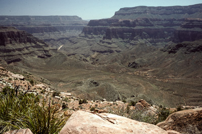 looked much greener than it had looked from the plane when we had
flown into Las Vegas yesterday. It was covered with small bushes. I stopped and rested a bit, looking for the rest of
the crew. One time, I saw A&S coming on down, so figured that now, they were about 30 minutes behind me. I had
not expected to be out front at this point. I came to the split in the trail, where the Deer Creek access trail goes off to
the right. I walked along, noticing that I would have to climb 100 or 200 feet or so to get out of Surprise Valley. As
I crossed a small drainage (4,029,150 N; 367,600 E), I ran into some fellows, about our age or so, that were camped.
They had tarps up to shield them from the sun. I talked briefly with them. They were doing the reverse of the route
we had originally planned. They had gone down Indian Hollow. They said it was tough, and did not see how people
could easily get up Indian Hollow. You can always rappel down, but sometimes you can't climb up. I congratulated
myself at having changed our route, and moved the takeout spot to Sowats Point. I looked at my watch, and it was 3:40
pm: time to move on.
looked much greener than it had looked from the plane when we had
flown into Las Vegas yesterday. It was covered with small bushes. I stopped and rested a bit, looking for the rest of
the crew. One time, I saw A&S coming on down, so figured that now, they were about 30 minutes behind me. I had
not expected to be out front at this point. I came to the split in the trail, where the Deer Creek access trail goes off to
the right. I walked along, noticing that I would have to climb 100 or 200 feet or so to get out of Surprise Valley. As
I crossed a small drainage (4,029,150 N; 367,600 E), I ran into some fellows, about our age or so, that were camped.
They had tarps up to shield them from the sun. I talked briefly with them. They were doing the reverse of the route
we had originally planned. They had gone down Indian Hollow. They said it was tough, and did not see how people
could easily get up Indian Hollow. You can always rappel down, but sometimes you can't climb up. I congratulated
myself at having changed our route, and moved the takeout spot to Sowats Point. I looked at my watch, and it was 3:40
pm: time to move on.
Next came to drop into the oven that the draw leading to Deer Valley becomes. By that time of the day, the sun has moved around, so you are still hiking into the sun. The trail was miserable. Big rocks which had been baking in the sun all day. Big steps: just the thing you want to do after this much descent. I had read that this part of the route was miserable. But somehow, what I had read did not convey the delight of this stretch. My feel felt like hot hamburger. I was glad that I had decided to go with the lightweight knee braces. I figured I would have been in even worse shape without them. I was surprised that A&S had not caught up yet. I figured that the Lance, Barbara, and Will group (who had an extra permit for one night in Surprise Valley) would not be seen by me until tomorrow, and that they were taking advantage of the short day for them by moving slow.
Boy, it hurt to make the big steps. 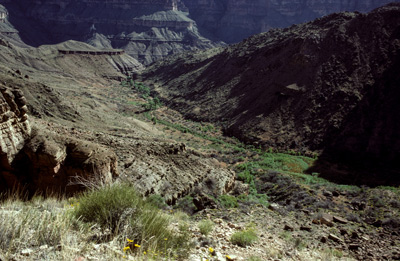 Even though I had taken some more ibuprofen, my heels were really starting to hurt. As I got further down the valley, I could finally hear the roar of Deer spring, and see that many of the sites along the creek were taken (how can there be this many folks here with a permit system?) But the ones closest to me were in the shade. As I descended over the big rocks, there was a fellow hiking uphill. He said he had a fellow with his party who was really beat, cause he had not backpacked in a long time. We chatted for awhile, but my feet were screaming for relief. As I turned to go, he stopped and asked me who I was. I told him, and he said "I thought so! I'm George from Gatlinburg, and I went on a backpack with you and Will Skelton to Alabama once (the Sipsey Wilderness trip Memorial Day, 1989). You are the editor of the Tennes-Sierran." Amazing, such a small world!! He told me there was a small campsite across the creek from their party, and that we should use it. It was the closest site.
Finally, I arrived at 5:45 pm MDT. I was so hot. I still had a pint of water left, but I went to the creek and drank straight. It was cool, I already started to feel better. What a route in. 7.8 hours to go 9 miles. Whew. I went down the creek to take a bath, after setting up my tent in a semi-grassy spot. I looked up, and could see A&S winding slowly down the wall above Deer Creek. Sue was practically hobbling. I was afraid that she had turned an ankle, but she was just really really tired. She and Andy had been trying to get grant applications in before they left, and all that work had left little time for mental or physical preparation. They got to camp at 7:15 pm, amazingly 90 minutes behind me. Amazing, cause it is always the other way around.
A&S took a quick sponge bath, and get their tent set up before it got dark. I had Mtn House something. There was a lot of it, and it did not taste too bad. We reviewed the days adventures. Sue indicated that she had just needed to rest a lot, cause her feet were killing her. I guess an obvious piece of advice for any weekend backpackers like us is that it is essential that you get as early a start as possible, and be mentally prepared for a long day. And plan to eat lots of Ibuprofen.
It got dark before everyone could totally finish getting everything together, but it felt so good to be DOWN, and near water. Sleep came pretty easy.
© Roger A. Jenkins, 1998