
Paria Canyon 1994
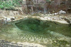
A cracked spring
Tuesday, April 22
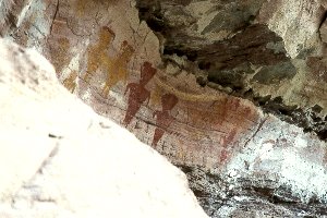 Our plan for today was to take advantage of the fact that, in terms of linear distance, we were not moving camp very far at all (basically up to the area near Crack Spring). We wanted to devote most of the morning to going up as far into Deer Creek as possible. Our first stop was to take a look (from the canyon floor) of some really nice pictographs on the right wall, about 250 meters above camp. They were a good reminder of the fact that, while we had not seen any modern humans since we started hiking, this place used to be crawling with folks. However, there was definitely a reminder of modern humans: a modern day neanderthal had attempted - unsuccessfully - to chop one of the pictographs out of the sandstone face. We hoped he had broken his hatchet in the process.
 Next we came to another set of pictographs, much higher up. We met Will near the pictographs. He and I decided to make the climb up onto the shelf, so that we could see the images really closely. Susie opted to wait for the slide show that always follows these trips. I don't recall the magnitude of the climb, which turned out to be not really difficult (hell, I could do it, which says how easy it is), but it was probably 50 - 75 feet. Deer Canyon was great, with just enough scattered big boulders in the bottom to keep the walking interesting. I had the sense that we were gaining some elevation as we moved up the canyon, but a look at the map suggests that it was only a couple of hundred feet or so up from camp to the falls. Deer Creek boxes out a bit more than a mile above camp. You walk into the cathedral like alcove, with a big (maybe 50 feet or so) pour off, and a wonderfully clear pool of water in the white sand bottom. This has got to be in the top five pools I have seen in canyon country. I could not tell how deep it was (it seemed at least over my head, although given the temperature of the water, I was not tempted to take a dip), but I think the clarity of the pool made it difficult to accurately estimate the depth. We goofed off, taking lots of photos, again reveling in the beauty of this special place, which was so close to the primary canyon. Sorta like finding a diamond in the rough.
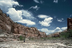 We had to turn around, as from this point, there is no way a human without very sophisticated climbing gear could proceed. Susie and I got back to camp, and after finishing our packing, decided that, as long as we were at such a nice water source, we would go ahead and eat an early lunch. This would maximize our rubber necking time as we headed up to Crack Spring Camp. After lunch, we went back out into the main canyon, and headed on up. While it had started out a bit cloudy early in the morning, it had turned into one of those glorious canyon country days: warm in the sun, cool in the shade, and a to-die-for deep blue sky, with just enough puffy clouds to break up the blue. The nearby red rocks, and the spectacular white cliffs in the distance were reminiscent of Zion. The fact that we did not have too much time under full pack made it even better, if such was possible. We pulled into the campsite, which is at (Zone 12, 4138445 Northing, 409673 Easting) and just opposite and maybe 50 yds upstream of Crack Spring. We were aided by Lance's yellow rubber gloves.
 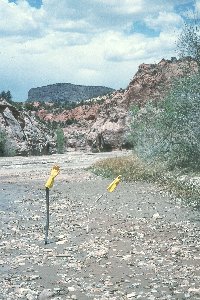 He carries these in canyon country because he says that the alkaline water chews up his hands. From a couple of hundred meters below camp (the site is not really visible from the creek bed, although I knew where to look), we noticed these strange shapes in the river bed. As we approached, we could see that Lance had formed the two gloves on sticks, with one of the fingers pointing the way into camp. We had arrived at 1:45 pm, less that about 90 minutes after we left our previous camp.
We had chosen this location primarily due to the water quality, and its proximity to Lone Rock. Kelsey uses Lone Rock to define the point at which one can leave the canyon, heading for the Upper Death Valley trails, which eventually lead into Hackberry Canyon, our intended route. As it turns out, it was probably the best campsite we had on the entire trip. It had been used, but not frequently. Kelsey also raves about the water quality in the spring, with good cause. It is flowing really well, is nice and cold, and is clear as a bell. None of us, except for Will, felt any need to treat it. Of course, arriving into camp so early afforded lots of time for the group to scatter even more. Several folks seem to want to check out the supposed route out of the canyon, fearing, I think, that they may have been sold a bill of goods by yours truly, assisted by Mike Kelsey. Sam, Kevin, Sue and Andy and George were off checking things out. Susie and I decided to do a bit more camp clean up chores, such as laundry, bathe, and then go exploring. We knew we would have all day tomorrow to really put on our exploration shoes, so neither she nor I felt the need to travel too far. 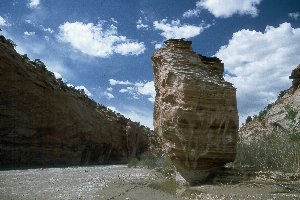 We did go up to Lone Rock, which is pretty obvious when you see it (just a big, tall rock standing by itself in the river bed). We got up there in time to see the crew coming down, reporting that the route planned for Thursday would go. This seemed to be a perfect time to do some photography. Andy had a 24 mm lens with him, so I borrowed it for a bit to photograph a little overhang (one of several) right below Lone Rock. Most of us headed back to camp, to take care of the inevitable chores prior to dinner. Everyone seemed to be pretty relaxed tonight. The canyon was much more narrow here, it looked like there would be some nice exploration tomorrow, and the weather looked like it would be holding for maybe another 24 hours. Still no other humans.
© Roger A. Jenkins, 1994, 2000