
Paria Canyon 1994
Wrong damn canyon!
Thursday, April 24 Fast forward 8 months and one day: it is Christmas morning, 1994. I open a package from Susie. The gift tag says "To Roger: No More April 24ths". Inside is my first hand held GPS. I am both thrilled and chagrined. April 24th would indeed prove to be an exceptionally challenging day. A lot of little things went wrong, which put three of us into unnecessarily difficult straits. A root cause analysis would probably show that a) I should have done a better job keeping the group together, or at least within eyesight of each other (such can be tough to do with this herd of cats) b) I should have insisted more, well, ..... insistently, that Susie and I take more than the five liters of water we carried between the two of us, and c) I should have recognized more quickly the impact of the dehydration on our mental state, and acted accordingly. The simple use of a compass at a critical time could have saved George, Susie, and I a lot of grief.
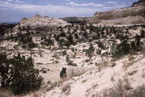
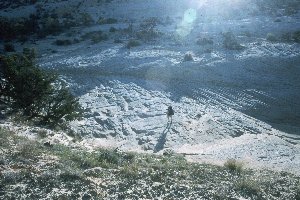 Susie and I set an alarm on my wristwatch, and we were up well before dawn. We heated water for breakfast while we attended to other camp-breaking chores. We were saddled up and underway, all seven of us who had spent the night on the river, at 6:55 am. It was just light enough to hike. We arrived at the exit point (4139227 Northing 409453 Easting) and were climbing up on the bench above the river within 20 minutes or so, as the sun was bathing the landscape in glorious golden light. This time of day is always a treat to hike, but not to get up for. Our first task was to wind our way around the drainage that actually flowed over a small pour-off right at our campsite. I am always a bit amazed to see how slow going off trail work is, even in open country like this. You are always gaining and losing a bit of elevation, because often, it is not clear as to the most energy efficient route to travel. We had to go upstream along the NW wall of the drainage before we were able to cross it. (Click here for a map of this part of the route.) By this time, our late-rising, bench-camping friends were up and underway with us. They reported they had spent a wonderful nite on the slickrock, and watching the sun die. After crossing the "headwaters" (just joking: there was no water anywhere up here, except in potholes after a rainstorm) of the drainage, we headed east, and then southeast, going on the northeast side of the little knoll marked 6145.
  We were trying to stay at a more or less constant elevation, but it was usually more and less. Lots of up and downs as we crossed slickrock draws, indentations, etc at the north end of Johnson Hole. We would go up 50 or 100 feet, and then go back down, and then back up. It was always a question of the route of least energy expenditure. You could stay at constant elevation, but you would end up walking 3 or 4 times the distance. Of course, as we gained a bit of elevation (we were now about 1000 feet above camp), the density of the little juniper trees increased, decreasing our ability to see immediately out in front. It was a warm, sunny day. Not unbearably hot, but sufficiently dry and warm to really suck the water out of you. I had started with my two one liter water bottles filled, as well as a bit more than a liter in our water bag. Susie had both of her bottles filled. I was already through one bottle, and we had not even reached the warmest part of the day.
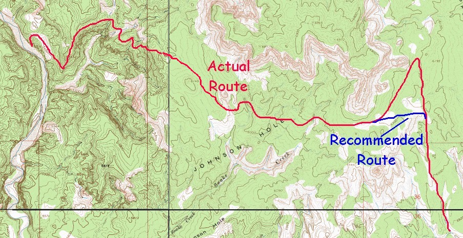
As we skirted to the south of the escarpment that goes to 6900 feet (UTM Coordinates 4138429 Northing 414357 Easting) we decided that it would be a good place for lunch. ( Click here for 226 Kb topo map overview of first half of route. Note that the actual route we traveled and the recommended route are both marked.) It would also give Will and the two Barbaras time to catch up. Barb M was really dragging, due to an awful cold. Barb A was moving slow, but she may have just been tired. (This was probably my first mistake: I should never have let the party get this spread out.) The 8 of us had lunch together. Will and Barb M showed up, and they indicated that they would wait for Barbara A. The map in Kelsey's book shows the route turning NE to go along the SE wall of this escarpment, and then turning due south to drop down in the drainage. We followed that route, but after going through there, you can see that a short cut directly down into the drainage would easily save nearly a mile of hiking in sand. 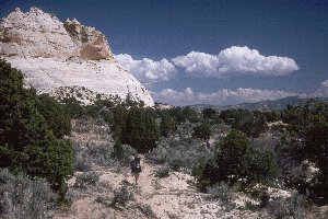 We had gone about 3/4 mile south of the spot where the route makes its turn to the south, following a cow trail, when we realized, that despite our very leisurely pace, the other three had not caught up yet. So just above where the drainage cuts to the southeast, and begins to go into a steep sided canyon, we stopped to wait. And wait, and wait. Lance and I climbed a little rise to our immediate east to see if we could see the party of 3. We had no luck, but Will reported later that he thought he had seen us, and had tried to signal with a mirror. Unfortunately, he wasn't using signal mirror (the type with the hole in the center, so you can see the spot you are putting out) and we were not looking when he flashed us. After waiting more than an hour (of course, evaporating precious moisture all the time), we realized that something was wrong. We were afraid that someone had become hurt. Andy and Sue took off retracing our route. They returned about 40 minutes later and said they could see no sign of the other three. Then we made what - at the time - seemed like a pretty rational decision, but in retrospect, seems pretty bad. We decided to split the main party. George and I are generally recognized as being pretty good route finders, so, with Susie along to supervise, the three of us took off. The plan was for us to take the route that was most efficient, set up some rock carins along the way to help the others find the route more quickly. In the meantime, the party of 5 would wait some more for the other party of three, and if they did not show up in an hour, would start to follow us. Keep in mind it is starting to push 5 pm, and we have been hiking since 7 am.
 For some reason that I can not figure out, we followed a route taking us up above the drainage that we ultimately should be following as it curls around to the east (see map). Maybe the route looked too difficult in the stream bed, maybe this other way just felt right, I don't know. But it cost us valuable time and energy as we took the scenic route, winding up and down around through Upper Death Valley. (After doing this route, I would recommend staying in the stream bed.) Finally, we decided that the drainage didn't look so bad, so we dropped into it, at least until we could round the NE headlands of the big butte marked Cottonwood 6634. It looked to me that the Kelsey route seemed to stay at an elevation of 5750 feet as it headed SSE to the west of Cottonwood Butte. So, rather than staying in the drainage for a ways longer, we headed off at that elevation. We stopped to rest, as it was now 6:40 pm, coming up on 12 hours of hiking. Susie took her last sip of water, and I split mine with George, who had run out a while back. I don't think I realized how seriously dehydrated we were. We look at the map, and said, ok, there are three little washes that flow east off the Cottonwood headlands. We know that the third one would take us to the little dimple canyon that is on the west side of Hackberry. That little side canyon (4133620 Northing, 418459 Easting) has a blasted out cow trail in it that goes into the floor of Hackberry. So, all we have to do is to count washes: one, two, and three. Hang a left, and we are nearly home.
In canyon country, these little washes are usually pretty prominent when you are hiking. You come to a spot where water flow has cut a 10 foot trench that may be 50 or 75 feet wide. You drop down in, cross, and climb the other side. Yeah, well don't ever count on it. We counted wash number one, walked about a half mile, and drop into and out of wash number two. Based on the map, we should have soon come to wash number three. So we hiked on, and on and on. At one point, I recall picking up what I thought were Barbara M's boot prints. They walked south for a bit, and then strangely headed off to the east. I recall mentioning to George and Susie: "Why in the hell is she going that way??!!" That should have been a signal to do a serious look around. But we were way too tired and thirsty and dammit, we had to find that third wash. Never once did any of us consider doing what should be obvious to anyone looking at the topo map of the area: pull out one of our compasses, and take a reading off the very prominent Cottonwood Butte. We just kept on hiking and hiking. We seemed to be hiking in a southeasterly direction, so I just knew we should hit that wash, or the canyon into which it flowed. Then finally, we came to something that looked like it dropped into a little canyon. OK, it wasn't so little, in fact, it was a helluva long way down, and no cow trail here, just very careful scrambling. Inexplicably, I was thinking, OK so this doesn't quite look like what I remember that little dimple canyon on the side of Hackberry should look like, but maybe I am just confused. We trudged on, along the sandy canyon floor. I kept thinking: Boy, look how steep those walls are. If we are in the wrong place, I don't think any of us have the energy to climb out. We are stuck in here and there is no water. I did not share these thoughts with the others. George was pulling out ahead, and I noticed that the canyon was taking a little bend. We had hiked more than a third of a mile in the bottom. It was at this point that George yelled back that the canyon went on quite a ways, and that it hit us like a bomb that we were indeed, in the wrong damn canyon. I pulled out the map (Why wasn't it out all this time? Now days, in tricky spots, I keep my topo map out and visible.) and realized immediately that we had in fact dropped into Stone Donkey canyon. I frantically got out the hiking guide copy, because I remembered Kelsey saying something about a blocking falls in Stone Donkey, and I thought shit, if we are above that falls, we are totally screwed. A quick read comforted me, as it seemed like the blocked route was further up the canyon than we had come down.
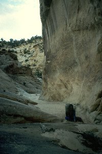 Interestingly, at this point, I became extremely energized. Perhaps because I knew that we had to have less than a mile to get to Hackberry, and although daylight was pretty much gone, I knew we could make it. ( Click here for 272 Kb topo map overview of second half of the route.)Stone Donkey has some neat spots in it, which I resolved to look more closely at - like tomorrow. I pushed on ahead, I guess because my adrenaline was pumping harder than others. Suddenly, I came to a pour-off. I could see lovely water on the downstream side. I looked around, and in the failing light, I could see a way around to the right, and called back to George and Susie that we had wonderful water just ahead, and that it should not be tough at all to get around the pouroff. I was down in a flash. (Note here that I had not even noticed the huge hole that goes through the rock and drops maybe 10 - 12 feet, at a spot Kelsey calls Doughnut Falls. In my addled state, I had nearly stepped into a disastrous situation.) By the time that George and Susie got around the pouroff, I had polished off my first liter, and was working on a second. Beautiful, wonderful water. (Note that I had mistaken this for the spring marked on the topo map, but in fact, that spring is maybe another 150 meters down canyon.) We filled our water bottles, not knowing the water quality situation in Hackberry, and pushed on. We pulled into Hackberry at 8:15 pm, 13 hr and 20 minutes after starting. It had been one hellaceous day.
We found a flat area just up from the confluence of Stone Donkey and Hackberry. We set up our tents with flashlights. George made some Gatorade for dinner. Susie and I, feeling better now that our brain cells were starting to rehydrate, decided to clean up a bit, and fix our "emergency" dinner. On any long backpack, we always take one dinner of Mountain House Lasgane (she eats the single serving size, and I eat the double). That way, if we have a day like we just did, all we have to do is heat water and pour it in. This day certainly qualified. I think George was asleep from exhaustion pretty quickly. We were down by 9:30 or so. Of course, in the back of my mind (and I am sure that of the other two) was concern for the welfare of our friends. Had they found their way down? Was the party of three OK? We had talked about heading up to where they would have come down early in the morning before they could mount a search party for us. So we could not dawdle when first light arrived. But that was still 9 hours or so away. Right now, it was time to sleep.
© Roger A. Jenkins, 1994, 2000