Citico Wilderness Backpack:
A Computer in the Backcountry??!!
Great start!!
Saturday, May 26 Standing in the pouring rain, screaming at the GPS unit to give you some damn satellites so you can get a fix, and start hiking, may not sound like everyone's concept of a fun time. As they say, the weather had gone south. Way south. Perhaps it was particularly frustrating, since it had not supposed to be this way.........
The hike had started simply enough: Memorial Day often finds us on some backpack in the high country or latitudes, attempting to mentally forestall the onset of Tennessee's miserable summers. OK, they are not as bad as central Florida's. With the job of remapping the trails in several Wilderness Areas in the Cherokee National Forest, as a prelude to updating the Sierra Club's definitive hiking guide to these areas, starring us in the face, Memorial Day weekend seemed like a logical opportunity to put some mileage on our hiking boots. Sure, we would not be at the high elevations which we like to visit in late Spring, but we would camp along both the North and South Forks of Citico Creek, and just their presence alone could provide some cooling. With a clear and COOL weather forecast, and our hiking buddy Barbara's last minute agreement to join us, spirits were pretty high. Our plan was to test out the mapping of the trails, both location and distance, using the automatic tracking features of a hand held global positioning system (GPS), and download the tracks every 5 hours or so to a notebook computer. Now, backpacking with a notebook computer which weighs as much as one of our heavier backpacking tents probably seems like not really getting away from it all. Believe me, I agree, but since this was a test, I figured it was worth a try.
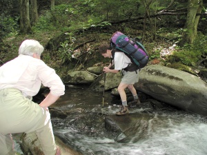 Barbara met us at our house, and we headed down the interstate to make the 90 minute jaunt to the trailhead, up the Cherohala Skyway from Tellico Plains. We loaded up and starting hiking the Grassy Branch trail, supposedly (this was my first time on this trail, and the "last" trail I had to hike to complete all the trails in the Citico Creek Wilderness Area) into a hanging valley. Maybe a "tilted" valley would be a more appropriate description, although the floor does drop out of the valley after a mile and half or so. For the first part of the walk, the going was pretty simple. We met a couple of really young fellows - barely 20, if that - who warned us that the trail was pretty hard to find in places. Judging from the quality of the equipment they were carrying (WalMart rejects), we sensed that lack of experience might have been an issue. The trail varies between steep drops and flat stretches as it follows the west side of Grassy Branch. As it gets ready to make its first crossing, the path does fade a bit, but looking down the creek to the other side, we could see where it picks up. The first few crossings were pretty easy, but it became increasingly clear that more and more care was required at each crossing to rock hop and keep water from washing over the boot tops. Susie decided that balancing on the slippery rocks was beyond her comfort level, so she changed into her Tevas, while Barbara and I practiced our high wire skills. While it is possible to do this section of the trail and keep your feet dry, each stream crossing at any time other than lowest water requires careful study of the route, and if you are in a hurry - which you should not be when moving through this lovely forest - it may be more time saving to go ahead and ford the creek. Besides, you will have to ford the South Fork anyway, so why wait to cool your feet.
It's 2.3 miles or so down the Grassy Branch Trail, and it is easy to spend 90 minutes or more on this stretch, due to the creek crossings. We got to the spot where the trail comes to its primary ford of the South Fork of Citico Creek, and Barbara and I changed shoes, while Susie plowed across. The water was mid-calf to knee deep depending on which hole you were standing in. Barbara tried crossing near where there is a cable stretched across the creek to assist hikers with the crossing, but found the footing more tenuous there than back downstream at the primary ford spot. By the time we got our act together on the other side, lunch was weighing heavy on our minds, and this seemed like a good place to stop. I turned off the GPS to conserve both power and track points. I was taking a track point (sorta like an automatic waypoint) every 20 seconds. That means 180 points per hours, or with a capacity of 1024 points, about 5.5 hours of hiking. I suspected that more creek fords would slow our progress to the point where I would have to stop and download points to the notebook computer, but wanted to postpone such until late in the hiking day.
We turned downsteam along the South Fork and within a 100 meters or so, had to ford the South Fork again. For those of you keeping score, depending on one's balancing skills and water levels, this could easily have been the 6th or 7th ford of the day. We met a group of three guys who told us how to deal with the next ford, but we soon learned that the particular information was superfluous: they had missed what is becoming a well used and maintained (by hikers) bypass stretch along the west side of the South Fork. The bypass is perhaps a quarter-mile long at most, but it avoids two fords of Citico Creek, which can be a good thing in high water. However, in high water times, I would recommend picking another route that keeps you on the ridge crests or the upper reaches of the creeks. The watersheds are too large and the creeks can turn to rivers way too quickly, and you can end up getting stranded for a day or more.
After the bypass, we began looking for the "trailhead" for the Ike Camp Branch Trail, also known as Brush Mountain. Like most trails in the Cherokee Wilderness areas, once you get into the wilderness, you will be lucky to find any trail signs. This is not by accident. Frankly, the Southeast Region of the Forest Service is not the most pro-wilderness Region in the System. It seems as though since they don't like wilderness areas in "their" forests, one way to make it just a wee bit more aggravating for wilderness travelers is to post no signs and do only the most minimal trail maintenance. Their argument is that if it is real wilderness, there ain't no signs. They have a point, but their policy seems more of an excuse than something to preserve the integrity of the wilderness. The folks who manage the Cherokee seemed to have been dragged kicking and screaming into the 20th Century, and it is rare to find a Supervisor or District Ranger who is a serious backpacker. That all said, the easiest way to find the place at which to ford the South Fork and start hiking up the Brush Mtn trail - if you can't read a map well, and don't own a GPS - is to look for another cable to "assist" hikers fording the creek, just upstream of where a large creek flows into the South Fork on the opposite side from the trail. Otherwise, the easiest thing to do is just go to waypoint 765,488 Easting, 3,920,474 Northing and ford the creek. It may take a bit of thrashing around to find the start of the trail on the other side, but after a bit, it will become apparent.
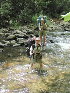 The North Fork Trail starts about 0.8 miles up the South Fork Trail (from its lower end) at a small sign in the woods, and within a 100 meters or so crosses the mouth of the South Fork on a bridge, that, by hiking standards, appears to have been designed to withstand World War III, or at the least, horses. After crossing on the bridge, and taking lots of photos for potential inclusion in the hiking guide, we headed on up the right side of the North Fork, but within a half mile or so, it was time to ford again. And again. Back on the right side, you have over a half mile of nice, boot-style hiking before it was time to do another set of fords. The stretches were just a bit too far to hike in my Tevas, especially with my bunion-deformed foot reminding me that scheduled surgery was thankfully only 4 months away, but not far enough to really get up a rhythm. We passed several nice camping spots, including one large area that we had used for a gourmet backpack in the mid-90's. We ran into a family that looked like they had just packed in a couple of miles. They did not look like hard core backpackers, and as we forded the North Fork just upstream of their camp, the gigantic T-bone steaks thawing in the creek confirmed our suspicions. Right after our 4th ford of the North Fork, we encountered a seasonal ranger out day hiking, carrying a machete. He claimed to be trimming back the vegetation, but we did not see much evidence of such. Before long, my GPS started beeping at me, and I wondered if it was trying to tell me it had lost its fix on the constellation of satellites overhead, or was just running low on juice. It seemed to be an opportune time to stop, checks things out, and download the trackpoints. It turned out that the batteries were running low (although lithium batteries can be deceiving), so I strained to get the track loaded to one software program (my favorite is TOPO!) before the power was completely drained. Naturally, this was the time that my notebook hung on boot-up and required a shutdown, reboot, and the lengthy process of disk and file checking. Resting on my pack, alongside the creek, this all seemed so incongruent. I had told Susie and Barbara to go on and find us a nice campsite, so I did not worry to much about falling a half hour behind.
After stowing the notebook, putting new batteries in the GPS, I hoisted and headed up the creek. I had a copy of the trail description with me, and had read it over back home, but since I had hiked the route several times over the last 15 years or so, I had not paid too much attention to it. I was surprised to come upon a spot that required another couple of fords of the creek. Then, it all came back to me. George and I had hiked this route downstream a few years back and had approached from the other direction. Since the trail guide had been written in 1990, what must have been a huge flood had torn away the right (south) bank of the stream bed, all the way back to a small cliff. So at this point, you have a couple of choices: ford the creek a couple more times, or take off up the hill side. The latter is the approach I took, but with backpack on, the time and energy efficiency of such an approach is pretty iffy. First, you have to climb nearly straight up a steep hillside, with more than a bit of vegetation, and traverse across a very steep slope. It can be a bit hairy in spots. The next thing is to make a move across some rocks and try to find a way to return to the valley floor without making a leap out into space. It can be done, but it is a struggle. I soon came across Barbara and Susie, and they reported opting for the low-energy trajectory: take off the hiking boots, and ford the creek a couple more times. The two of them were standing in a pretty nice campsite, but it was not as far up the trail as we had planned to go. They reported that a couple of fisher-guys had told them that there was a nice campsite off to the left in the woods, just above the NEXT ford, but beyond that, the camping opportunities were getting sparser. We opted to move on, and see if we could nail this recommended spot. Since it was not visible from the trail, we appreciated their directions, based on its location relative to some blowdowns. Susie had made 13 or 14 creek fords today, and she was ready for some major relaxing.
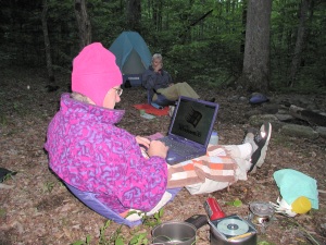 It didn't take us very long to find the site, a lovely little camp for 2 or 3 tents, about 50 feet off the trail on a little raised area. We were home, we had a nice access to Citico Creek for getting water and bathing, and with dinner in our near future, life was good. We pitched our tents, and gathered a bit of the staggering amount of firewood available. I say staggering, because, in contrast, the locations of the backcountry sites in the Great Smoky Mountains National Park are fixed, and thus heavily used. Oftentimes, if you want to collect a bit of wood, even for a low impact fire, you have to really hunt for it. In most of the parts of Citico, finding wood is like finding a blade of grass on a golf course. After dinner, I downloaded the remainder of the track points from the GPS for the day's hiking, and we built a small, "indian-style" fire, and chatted about the effort required to re-hike all the trails. Sorta like the effort involved in eating a great meal. A tough job, but someone has to do it.
© Roger A. Jenkins, 2001