Citico Wilderness Backpack:
A Computer in the Backcountry??!!
Another great day!!
Sunday, May 27 During the night, we were awakened by the pitter-patter of little raindrops on the tent fly. We hurried out to increase the nitrogen availability to the local flora, and dove back in the tent. Apparently, one of the predicted widely scattered showers was passing through. Susie immediately became gloomy at the prospect of hiking all day in the rain, but I fell back asleep when I realized that the pitter patter had gone away. At first light, I got out of the tent, and proclaimed it another great day, as the sky had cleared off, and all I could see was blue. Susie and I made a giant muffin in our BakePacker for breakfast, and chatted with Barbara. She and I chided Susie about being so pessimistic about the weather, and were ready to roll by 9:15, heading on up the creek.
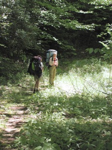
It was not long before it was time for our first creek ford of the day, and after another 300 meters or so, it was time to ford again back to the left side of the creek. A great way to keep yourself refreshed as you hike. After coming into a gravel-covered small camping area (I always like to camp on gravel, don't you?), we saw that the trail goes very very steeply up the slope behind the camping area, to regain another railroad grade. Of course, it wasn't long before it was time to do a very delicate rock hop/ford of a tributary of the North Fork. To be sure, the trail at this point, and most of the rest of the way up the North Fork is more of a route than a trail. It is easy to lose the track if you are not paying attention. The concept of maintenance is foreign, and our hiking guide to the contrary, there are few flat places to camp above 3 miles along the creek. Bivouac would be the more operative concept. We stopped for a brief rest, and let a couple of fellows from Huntsville, AL, catch up to us. The dwindling of the creek flow would suggest that crossing it would be less tricky, but there are several spots where attention is mandatory. We got to a small waterfall about 11:30, and I decided it was time for lunch. We had come almost exactly 2 miles up the "trail" and, excluding rest time, it had taken us 2 hours. If you want wilderness, this is the place to be.
 It was not hard for us to find the junction with the Cold Spring Gap trail: I had missed it once before, and the memory of trying to find it had heightened my awareness. Of course, the Forest Service, in claiming to keep the "wild" in wilderness, has a no-sign policy for junctions which are not at the edge of the wilderness. After a stiff, short climb, we all felt like we were on a super-highway. The Cold Spring Gap trail has to be the easiest trail in Citico. It contours and climbs oh-so-gently over the crest of Brush Mountain. The grade is barely perceptible, which felt great after the steep terrain and 1-mile-per-hour hiking rate that we had enjoyed on a good portion of this morning's hike. The trail is really a old road bed that has become grassy. In spots, it is wide enough to camp on, and it was clear that several parties in the past had done just that. The sky was blue and the air at 4400 feet was cool. We were moving at such a pace that we passed right by the unmarked junction with the Brush Mtn/Ike Camp Branch trail. (I had been on this route many times, and so I was not looking for it in particular this time. For hikers trying to find the junction while on the Cold Spring Gap trail, the best way to find it is to set a waypoint on a GPS and go to the spot. It is right on the crest of Brush Mtn, but since the trail is gradually ascending (or descending if you are headed north) at this point, and the trail contours continuously on this route, there is nothing really definitive by which to describe the area of the junction.
After about an hour of hiking, we decided we were not in that much of a hurry, and were deserving of rest break. I got out the GPS and estimated our distance to Cold Spring Gap and the upper trailhead for the South Fork of Citico as being less than 300 meters. We had been making very good time. I looked at the number of track points I had remaining on the GPS, and figured that I could easily get to our night's camp before I would run out, and so decided to postpone the download to the computer until we got to camp. Sure enough, it was a very short hop to the multi-junction with the Fodderstack Trail, the old road coming in from Beech Gap, and the South Fork of Citico Creek Trail. We noted that there were some trail signs at this point.
 When you start down the South Fork Trail, you feel like you are in an elevator. The route is steep. Very steep. It is easy to follow, but blowdowns provide a bit more of a challenge. In about a half mile or so, we bottomed out on the floor of the valley, and began to follow the old railroad grade that comprises the core of this route. In a bit over another half mile, we pulled up alongside what I consider to be one of the two finest campsites in the Joyce Kilmer/Slickrock/Citico area (the other being Bob's Bald). On the north side of the trail, there is a large, quasi-meadow, dotted with trees and covered with grass. It is close to the creek, but not in the flood plain, and appears to be the site of a abandoned logging camp. Will Skelton and I had "discovered" this spot more than a decade ago. We were backpacking in Citico, doing some checking on the trail descriptions for the South Fork when we got los ---- wait, let us not use that awful, value laden term: "lost." Let's just say we were mighty confused for a while. We had been heading up the trail, and had followed a strong path up a small creek, thinking it was the main trail. After a couple of hundred meters, it had slowly petered out. Since it was not clear where the trail "had gone," Will and I thrashed around on the ridge for some time. Ultimately, we burned a couple of hours finding our way back to the trail. Our original goal that night had been Bob's Bald, but it was becoming increasingly clear that such a goal was out of reach. When we had passed the old logging camp, it looked like a natural spot to camp, so we spent the first of what would become many nights at this lovely little spot in the upper reaches of the South Fork.
Barbara, Susie, and I were quietly pleased to see no one else here: the last time we had planned to camp here, there was a group of 15 woman scattered all through the meadows, and we ultimately camped on an old road grade a couple of hundred meters downstream. Tonight, it look like the only souls with whom we would be sharing this lovely spot were those of our winged friends, the mosquitos. They seemed to be out in force. Susie hastened her bath, to avoid getting any bites on the more tender parts of her anatomy, and dove in the tent, to insure protection. Meanwhile, I reveled in making my body cold enough by pouring creek water all over myself so as to confuse the thermal sensors of the mosquitos. Of course, I could not mask my carbon dioxide emissions, so a couple of the little critters managed to have an early dinner. While Susie and Barbara napped in their respective tents, I busied myself with critical chores, like studying leaf patterns, downloading track points from the GPS, and swatting mosquitos. I went up on the road bed about 50 meters from camp, and found that there were minimal amounts of bugs there, and reported such to the ladies, but could generate little enthusiasm for moving our kitchen site "all the way up there." So while Susie cooked dinner, I entertained myself by swatting more bugs. Since it was cool, my being encased in PolarTek enhanced my defenses. After a small fire, and more reminiscing, we all dragged ourselves to bed, having enjoyed another lovely day, and looking forward to a third.
© Roger A. Jenkins, 2001