
The Dirty Devil: Living Up to Its Name
The descent
George called back to me: "It's getting tired out here!" Indeed, on this last obstacle between us, and water and rest and flat and no rocks, it was getting very tired out here. All eleven of us were strung out in this trough called Twin Alcoves. Everyone was moving at his/her own pace, or dealing with his/her own private hell, as the case may be. Storm clouds were gathering to the northwest, and with daylight beginning to run out. Russ was down ahead of me, perhaps 30 meters. I looked down to ascertain the micro-topography into which I was about to step, and then looked up. A tumbling pack, that seemed to explode with gear as it hit a key boulder caught my eye. I looked around, wishing with all that I had in me that Russ had not been attached to the pack ........Saturday, April 23rd
 Fresh snow on the peaks to the east of Provo, and a lot of water in the motel parking lot signaled a chilly start to our day. The weather forecast for Hanksville, our rendezvous point, and town nearest to the "canyon insertion point," was breezy and cool, but no precipitation. A late-April snow could have turned our slickrock descent into the canyon into a nightmare. On the 4-hour drive down to Hanksville, we could see the storm clouds skittering off to the east. Whatever precipitation had been dropped in this latest event, it would evaporate quickly. We had planned to meet John Finger, our history professor buddy from Knoxville, who was on sabbatical at the University of Nevada Las Vegas, at the tourist information booth in beautiful downtown Hanksville at 11:30 am, so we were flying low. We got there early, and so was he. Always nice to pick up a few minutes. That addition brought our group to 11, although John would only join us for 3 days, as he needed to get back to professorial duties. There was Andy and Sue from Texas, Samantha and Kevin, George, Russ, the budding - at the time - author, who has since gone on to write several well received hiking guides to spots in Eastern and Central Tennessee, and Ray and Will. Andy Zenick had been a last minute substitution. Our buddy Paul could not make the trip, and hated to waste the slot, so Andy offered to take his place.
To say that this trip had taken more planning than usual was an understatement. First, we had to pull off the three body collision of A&S coming in from Texas, John from Las Vegas, by car, and the Knoxville crew. Next, we had to get very detailed instructions from the BLM ranger as to the locations of the trailheads. This was the days before digital maps and handheld GPS. Many times, when you are crossing the sandy mesas of south central Utah, all the dirt roads look the same, and all seem to head in the wrong direction. Most importantly, our success on this trip would be governed by the River flow. This was the days before the internet, where one can merely click on a hypertext link, and get real-time (or historical) water flow in nearly 5000 streams and rivers across the US.
I had to contact the USGS months in advance, get their computer printouts for stream flow at the Poison Spring Canyon station on the Dirty Devil (a few miles downstream of where we would be), and then do an analysis of the best time to attempt this trip. Pick a time when the snow melt is coming downstream, and crossing the river would be both difficult and dangerous. Of course, I had to interweave this all into a business commitment schedule of several very busy people. There seemed to be no "guaranteed best time" to go in the spring. You just had to take your chances. I had been calling the USGS telephone number where the information was available regularly, and had done so the day before we left. The flow looked to be somewhat greater than 200 cubic feet per second, which the ranger had assured us was doable. Sometimes, the line between doable and life threatening can be very fine.
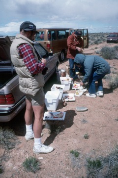
 Our plan for the trip was to drop off our shuttle vehicle at the trailhead northwest of Angel Spring, cram all of us into the big van and John's car, and head back to Burr Point, where we would start the trip. The BLM ranger had told me on the phone when heading out to the Angel Cover Spring Trailhead, use the northerly approach, since you are heading downhill when you hit a sandy stretch (easier to keep momentum up) and look for the turn-off at orange-painted telephone pole tops. That seemed to work. We decided to celebrate our success at getting out to the trailhead by having lunch. The weather being still pretty blustery, most of us made sandwiches from groceries purchased in Salt Lake City wearing down vests and Gore-Tex jackets. We came out the southern approach road (intersecting Utah 95 about 10 miles outside of Hanksville), and it was much rougher. It was not a long drive down to the turnoff to Burr Point, and road was pretty good, but it winds around the canyon heads a lot. There's one fork that you come to, and its not clear which one you should take. We guessed the right one, and were correct. Sometimes you get lucky. We finally got to the trailhead a bit after 1:30 pm. It was breezy and cool, and most of us started (when we actually started, which was about 40 minutes after we pulled up) hiking in some sort of jacket or windshirt.
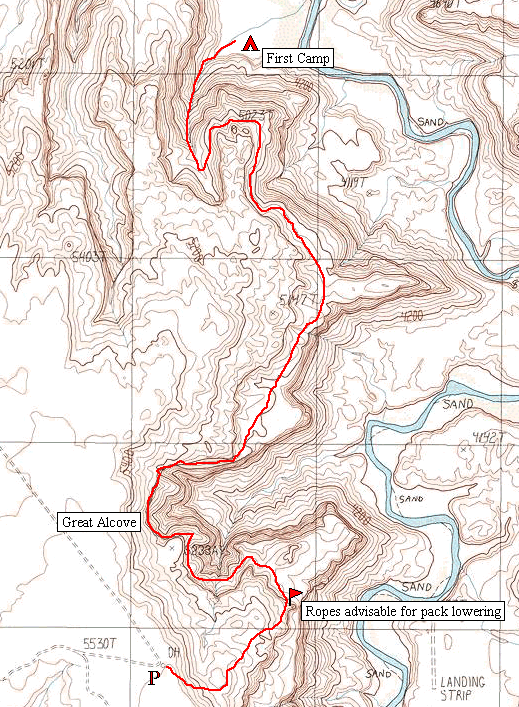
It is time to say something about Michael Kelsey's book, Hiking and Exploring Utah's Henry Mountains and Robbers Roost This is the hiking guide that seems to have the most information on the area. Kelsey has done a magnificent job of opening up this area to hikers, to the lament of some and joy of others. Kelsey has some wonderfully accurate descriptions of the approach routes and canyons in his book, and they are, for the most part very accurate. EXCEPT for the time that it takes to hike the routes he takes. Over the years, we have learned that we have to double (at least) Kelsey's estimated times for covering distances. His maps are worth their proverbial weight in gold, due to their accuracy and the amount of information they contain. For those of you who might read this story, and not want to buy the hiking guide that covers the area (c'mon, it is only ten bucks), I have produced a map that shows our route into the canyon, which is essentially the same as the freehand maps Kelsey uses in his books. One would do well to study the map prior to the descent. The descent is "interesting" enough, without adding to the excitement.
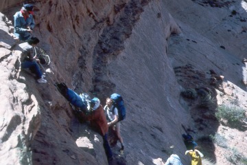 After plenty of screwing around, it was time to get started. We all took off at slightly different times, angling down the slickrock and sand onto the Navajo sandstone. Walking was pretty easy at this point, and we all seemed to be nearly giddy. It was not long before we came to the first obstacle. As you drop to the Kayenta bench, near two needles of rock, there is a major drop (approximately at 547,857 Easting, 4,225,136 Northing). By the time I arrived (I always seem to drag behind), part of the crew had managed to drop off the bench, and were beginning to line packs down with a rope. Without a pack, it was not horrible dropping off yourself, but I appreciated my friends around to guide my butt in the right place. Immediately following the rope episode, we got to another shelf that required hand lowering of the packs. (It did appear that by heading to the northwest about 100 meters, the terrain became less steep, and we might have avoided the second bout of pack lowering.) All the pack moving burned quite a bit of time, so we had to push on quickly. As we headed to the northwest around the base of the Navajo bench, we came face to face with an obstacle which looked to be a show stopper: The Great Alcove. In short, as you look at the alcove from a rise about a third of a mile from the inner (western) face, your immediate thought is: NO WAY!! One would have to be a fly on the wall to make it around, and there were clearly no other possibilities from this point. How could Kelsey steer us so wrong??!! I kept thinking to myself: there has got to be a way. Otherwise, Kelsey would not have described the route as doable. (Note that the original edition of the book we were using was published before he got into his canyoneering period.) Ray couldn't stand all the worrying being expressed, so he dropped his pack, and headed around the head of the draw that runs north/south, in an attempt to scout the route. After about 15 minutes watching him slowly follow what must be an obvious albeit circuitous route, I could hear some concerns expressed (won't mention any names) to the effect: The problem is that Ray can do anything, stuff that the rest of us would in no way be willing to threaten our future doing. There is a bit of truth to that: in 1985, Ray pioneered a route which clearly had been done very few times in recent years into Lower Grand Gulch. We all were able to survive the route, but the exposure and footing were life threatening, and there was no way to anchor a rope. You had to have faith in friction. After listening to all this concern, I decided I would take off after Ray and inspect the route myself. That way, if I could do it, then anybody could.
Ray was moving way out in front, and I saw him get to what I thought would be the end of the impossible stretch. He turned around, and even across the distance that separated us, I could FEEL his smile. He beat me back to the start of the stretch that appeared problematic, and in his usual relaxed, West Virginia drawl, said: "Nooooo problem." Apparently, there is a shelf that is about 8 feet wide all along the "impossible stretch" which is nearly as smooth as a sidewalk. I yelled back to the crew that we had it made and to follow our tracks. Slowly, but with some determination, you could see them across the canyon hoisting their packs, and heading in our direction. As they passed one by one, we assured them that it would be, indeed, no problem. After I got back to my pack and started re-doing the trek I had just made twice, I could see most of our folks were past the spot, and I was looking forward to actually crossing it myself. Of course, Ray and I had covered an extra mile and a half or so this afternoon, but I tried to look at it as an opportunity to get to know your terrain, so to speak. When I got to the actual shelf, it was indeed no problem. Nice and wide and safe feeling, as long as you don't get too close to the edge. I avoided such. It was very easy going, but all this walking had made me thirsty, despite the cool temperatures. I stopped, took off my pack, leaning it up against the canyon wall, took a long drink, and hoisted again, since I had fallen way behind the pack.
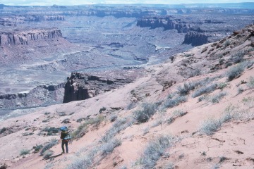
 It is about 2 miles of pretty easy walking around on the Kayenta bench: pretty much smooth slickrock, and views that go on forever. It is kinda neat walking below the canyon rim, but way above its floor, catching that golden lighting as the sun sinks lower in the sky. That is the most positive way of couching the fact that it was getting late. I knew I would be lucky to walk the bench around to the descent in the Twin Alcoves in an hour, and that would be pushing 6:30 by the time I got there. It is "only" a 700 foot descent down the alcove, but I knew it would take some serious time. Some folks had stopped to rest before they began their descent, allowing me to close the distance, but I was still pretty much in the rear. I kept pushing, because I knew it was getting very late. I did not want a repeat of the 1983 descent into Dark Canyon, when we came damn near to folks getting stranded by darkness high up on a difficult slope. From the top of the Twin Alcoves, the descent did not look all that horrible, but it was rough, with lots of boulders and small "discontinuities" (read small cliffs). Despite the fact that we had all started the descent close together, we got strung out pretty quickly, all bowing to our own limitations and inner fears. I was getting seriously tired, and I knew George was as well. Russ was ahead of me at one point, and gently let his pack down over a short shelf. The pack immediately took on a life of its own, tumbling in slow motion down the draw, until it exploded like a grenade had gone off inside it. Russ seemed to be OK himself, but was a bit taken aback by how a simple incorrect placement could scatter his gear all down the trough. After I negotiated a small cliff that required hanging onto a small tree (by now, the tree has either gotten sturdier or has died. If so, a rope would be useful.), I ran into problems of my own. Just before the trip, I had purchased a new pack (Kelty Super Tioga) and had violated one of my own rules: Never take a piece of gear on a long trip that has not been field tested. Why not?? Well, about halfway through the descent, the right shoulder strap came apart: just broke it two pieces. I was stunned. How could a piece of Kelty gear disintegrate with no use?? (In a subsequent exchange of letters with the product folks, I learned that Kelty had moved the manufacturing "overseas" and they admitted to having some "quality problems." Kelty sent me several sets of new shoulder straps in addition to fixing the ones that had come apart here. Oh, did I mention that the other strap came apart 20 minutes later?)
I always carry a couple of extra sleeping bag straps in my pack: never know when you will need them. I needed them now. I jury-rigged the straps around the shoulder pads, and tied them to the torn ends of the pack straps. It looked awful, but it worked. Besides, I did not have a lot of time to screw around. Russ and I, due to our gear problems, were pretty much in the rear, although Will was a little way back. I could hear the storm clouds booming to the northwest, and the wind was starting to pick up. Oh joy. I hit the floor of the canyon at 8:20 pm, 6 hours and 10 minutes without sitting down to take a break. I had only drunk one of my two quarts of water, but there was no rest for the weary, for sure. It was starting to spit rain, and I had to get my tent up. The great thing about the Sierra Designs Clip Flashlight is that it can be erected quickly. I turned around to see, in the fading light, if everyone was off the hill, so to speak. It was my one deference to group safety, and then it was every man for himself. I could see that both Will and Russ were through the most difficult part, and were about ready to touch the floor of the canyon. The storm hit with full fury just as I draped my fly over my tent. I quickly staked down the vestibule, threw my full pack in through the door, and dove in after it. The rain pelted the fly, but I felt pretty secure. I lay there (there is not much you can do in a small tent but lie down) and tried to figure out what to do about water and food. I hated to use any of my remaining quart of drinking water to clean up with, but I was horribly dirty, sweaty, and in a state of general foulness. But sometimes Mother Nature, after she had beaten you down, will throw you a crumb. I looked out into the vestibule, and noticed that my nylon ground cloth was sticking out into the weather. The rain was hitting the fly and running into the vestibule, filling a depression made by my knee as I was getting in. There was nearly a cup and a half of nice clean water with which to bathe. Hey, at the time, it seemed like a lot. I gingerly scooped the water off the ground cloth and into a pot retrieved from my cook set, and went about taking a bath with less water than I would have used to re hydrate my dinner. I am not sure how clean I got, but it made me feel better. Dinner was a quart of GatorAide made up with my last drinking water. I hoped we could get water out of the river, but I was not so sure. I stripped off my outer clothes, pulled the sleeping bag over me, and listened to the rain moisten the wild flowers on this, one of my toughest descents to date in canyon country. Tomorrow would come, but not until after some blessed sleep.
But this is only one person's view. You might want to read Russ's take on the whole thing. He's a better writer.
© Roger A. Jenkins, 1988, 2001