
The Dirty Devil: Living Up to Its Name
To Angel Cove Spring
Thursday, April 28
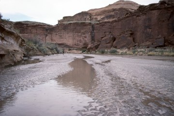 I figured that we had an easy day today: only a few hours of hiking to Angel Cove Spring. I pulled out of No Man's within sight of several of our crew, but few of us were sticking together: a reflection of the independence of this group. Oh sure, we could see each other, but usually from a hundred meters away or so. The river was flowing well, but not too high. One of the more annoying aspects was the mud flats. Maybe the river had subsided over the last couple of days, but it seemed that when you crossed some of the flats along the river, the mud could suck your shoes right off. About halfway between No Man's and Angel Cove Spring, there is a huge bend in the river referred to as the Saw Tooth. It looks much different in real life than on a topo map. The map suggests that there is a real knife edge, but in actuality, the knife edge is pretty heavily "serrated," and it would likely be possible to cross it, IF you found the right place to do it. As it turns out, none of our party figured out how to accomplish such. If you are hiking upriver, it seems necessary to begin the climb way downstream of the actual Sawtooth. Otherwise, there is no way to get up near the ‘tooth itself.
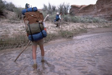 We all pulled into the Angel Cove area 3.5 - 4 hours after we left No Man's. The trip had not been more difficult than the previous day, although on one stretch, you have to cling pretty tightly to the east bank of the river, and you find yourself hiking up in the rocks above the stream bed, avoiding the river, and managing to save a couple of crossings. Nevertheless, it was something like 16 river crossings between No Man's and the Spring. Angel Cove Spring is a pretty interesting area. There is a huge overhang, and a seep flowing down into a nice pool. There was evidence of people having used the area for arrgghhh!!!! bathing. (Indeed, Will would later report he had come across the previous day a couple of college age girls (although from their behavior one might call them infants) standing in the spring washing their hair!!! They were with an outdoors skills group from Santa Clara College (now University) in California. Will, in an admittedly less-than-completely-tactful approach, asked them how they could justify polluting our drinking water. Their response: Well, you treat it, don't you?")
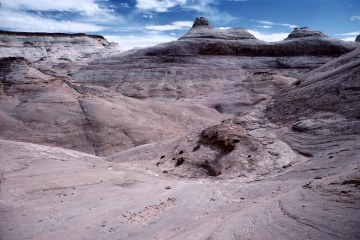
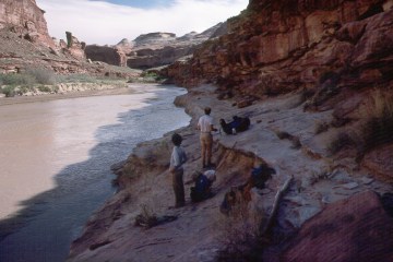 We found Will and Sam and Kevin's tents above the stream bed, downstream of the spring. The accommodations weren't perfect, but they would do. We were into camp in early afternoon, and the reasonable thing for many of us to do was to go out exploring. Since tomorrow would be a layover day, one that we could devote entirely to Robber's Roost, several of us headed across river and up the Angel Trail to the east. This would end up being the scenic highlight of the trip. As you climb up out of the main canyon, across the river from the outlet of Angel Cove Spring, the Navajo sandstone is absolutely incredible: it is like frozen sand dunes, with dollops of sandstone tossed thither and yond. The view of the Henry Mountains is incredible, and I was wishing for a nice blue sky, rather than high, thin overcast. Andy and Sue joined me for a good chunk of the climb up, and then we split up, each seeking our own personal paradise, I guess. Or at least, personal space. I could have photographed for hours, but I knew I could not stay. It was time to get back, and clean up, although not in the spring. Actually, I decided I would head downriver a bit, and take advantage of the water coming out of Beaver Box Canyon. I figured as long as I did not have to drink it (there must be a reason why they call Giardia "Beaver Fever"), it was OK to clean up with it.
 While Andy and Sue and I had been up on the Angel Trail, Russ had gone up Beaver Box Canyon, and reported - presumably to no one's surprise - seeing a beaver. Ray and George seemed to have been scouting an exit route: Ray always gets antsy toward the end of the trip. I guess part of it is his desire to keep to the schedule, and not being able to find one's way out would be the ultimate ruination of an itinerary. (This searching for an exit spot is not necessarily a bad thing. Eight years later, in 1996, Ray and George, in the process of searching for an exit from a tributary of Road Canyon, would discover a spectacular 150 foot pour-off. Certainly the most spectacular that any of us have come across.) Meanwhile, back at camp, we had heard that Will had gone for a brief swim that day, and all of us gave him a hard time. But secretly, we all knew that but for the grace of the Almighty, we would have been swimming too. Tomorrow would be our last dealings with the Dirty Devil, on a trip up to Robber's Roost for our last of three layover days. The canyon exit was on the same side we were on, so exiting could be done with dry feet. In fact, our campsite was less than a mile - as the canyon wren flies - from our shuttle car, but would require several miles of walking to get to it. But first, it was time to explore Butch Cassidy's hideout.
© Roger A. Jenkins, 1988,2001