
The Dirty Devil: Living Up to Its Name
Larry and No Man's
Tuesday, April 26
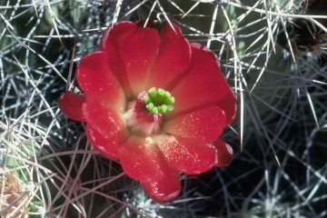
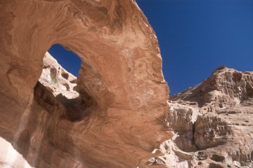 The plan for today was to spend the morning exploring Larry's Canyon, and head on up to No Man's Canyon in the afternoon. As we sat around the fire at breakfast in the 40 degree air, I could see my carefully planned itinerary deteriorating by the minute. George and Russ were going to do some heavy duty relaxing in camp this morning, while Will, since he had already explored Larry's Canyon last night, was going to get a jump on things by heading up to our next camp. I think he was trying to make time, and he sorta hates to not keep seeing new terrain when he is out on these trips. The rest of us were going to stick to the original plan, and explore Larry's canyon and then move up to No Man's. I pulled most of my gear together so I would be ready to roll when I did get back to camp. I had put in some virtual pushpins into my mental map of the canyon - places I had noted on the way up to get water last night. One of the first stops was a large Claret Cup Cactus, that just begged to be photographed. Next was a neat circular arch in the canyon wall (north side). You had to get up underneath it to see it, but with the blue sky and the red rock, well, it was great to be in canyon country. We got upcanyon far enough to confirm that Kelsey is indeed accurate in his marking of a canyon exit (south side). It is downstream of the side canyon coming in from north. (546,017 Easting, 4235356 Northing is the approximate point.) Several of us climbed up a ways, just to confirm that it was headed out. Not too difficult.
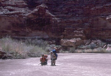
 I got back to camp, and had a spot of lunch, before pulling out around 12:30 pm. It is maybe 4.5 - 5 miles up to the mouth of No Man's Canyon, and I had figured that the going would be pretty easy. And it would have been, had we not had to cross the infernal river so many times. There are several big bends in this stretch, and the river goes right to the wall of the canyon, forcing one into the water. I took me about 3 hours to get to camp. Those of us that had gone up Larry's were sort of in a group, as long as your definition of "group" is loose enough. For many of us, it was a rough haul. The river was particularly difficult in this stretch. I have this image (both in my mind and on film) of Andy B and Sue walking along together. He is walking in water at a mid- lower calf level, holding Sue's hand, and she is up to her waist. Sue ruined her camera that afternoon, by giving it an unscheduled bath. The holes in the river bottom were very difficult to recognize, and when I got to camp, George, who had left camp some time before the Larry Canyon explorers, had gone in up to the base of his neck, and had swamped his camera, which was in a small holder on one of his shoulder straps. Will reported getting stuck in some mud and nearly drowning his camera. It was a rough afternoon, and I considered myself really lucky to have survived with my pre-existing net worth in optical gear still intact.
Will, having left our previous camp around 10:40 am, had a tough time of it. Here are his words from his audio journal:
|
The river today made large winding loops and because the water level has dropped, there are generally long mud flats of up to 10 acres in size. I walked a lot on the mud flats, although the queasiness of the mud and sand in some places reminds me of quicksand and worried me some. When not on the mud flats, I followed old cow trails on the benches above. The easy walking of the uranium road ended yesterday between Sam's Mesa Box Canyon and Larry's Canyon when we left the Chinle sandstone formation. Larry's Canyon is principally in the Wingate, Kayenta, and Navajo sandstone formations while No Man's is principally Navajo.
|
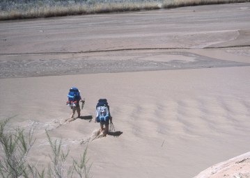 The river is almost impossible to "read" in the sense of deciding where the deep holes are, where the strongest water is, etc. There is even such a thing as a "spontaneous rapid" which appears and then goes away. So it is very frustrating as a wrong step gets you into sucking mud which leaves you feeling very uneasy. My worst dreams came true about a half-mile below No Man's when I literally almost went under completely. I had just stepped down from the shore into the river and the mud was somewhat deep, as usual. However, rather than getting better, as it usually did, all of a sudden I was having trouble pulling my feet out of the mud, and was sinking down. Whether it was quicksand I don't know, but I ended up on my knees, "knee walking" back to the shore with the camera held above water in one hand. I was truly in danger of getting an $850 camera and lens wet, which would rather almost surely have destroyed it. After that, I was even more careful but it is hard to be careful when you don't know where the bad spots are.
 As I pulled into the mouth of No Man's, I was a bit befuddled. None of our party was there. The mouth has a place where you could put up tents, but it seemed awfully brushy, and I was hoping that the advance party had found someplace better. Just about that time, one of them showed up, and indicated, with a lilt in his voice, that we were changing the itinerary again, and NOT camping at the mouth of No Man's, but in a much better spot up in No Man's. Since it had been a short day, I wasn't complaining, especially since I was planning to spend a couple of nights here. In fact, our camp was in a nice area, although not as nice a spot as the previous evening, but it had scattered grass, a few bushes and some trees. Best of all, it was reported by the advance crew to have running water just a few minutes up canyon. Sounded like home to me. Even though I had not come really far, with the walking this morning in Larry's, I was ready for a rest. Andy and Sue were just a couple of minutes behind me, and before long, all the chicks were in the nest, more or less. Will had already set up camp, and had taken off exploring. Sometimes, it is hard for that man to sit still. It turns out that he was up No Man's, exploring some Fremont Indian ruins that were quite a way above the canyon floor. It took more risk than I was willing to put forth to get up and into those things.
Will was back in time for dinner, and bitching about the quality of the freeze-dried vegetarian dinners he had brought. He claims I took pity on him, and provided a taste of some pasta and cheese combination of my own creation, but for the life of me, I can't remember what it was. I have see-sawed over the years between homemade trail dinners, using some of the convenience products in the grocery stores as a base, and the freeze dried dinners you can purchase from a variety of outfits. For convenience, you can hardly beat the latter, but sometimes the taste is not exactly what you had in mind, based on the description on the package. As I have become more experienced, it is pretty simple to whip up the ingredients at home for a seeming feast on the trail, as long as I pay attention to the weight of the materials I am using. Two ounces more each day is an extra pound for a week's worth of food. Anyway, after dinner, we all decided a campfire was in order, as a way of commiserating about the day's drowned photo gear. It had been a challenging stretch of river, and there were jokes about getting T-shirts printed with the phrase: "I crawled the Dirty Devil" emblazoned across the front. The night was cool, and the stars, par for the course this trip, were outstanding.
© Roger A. Jenkins, William H. Skelton, 1988, 2001