
Side Canyons of the Lower Escalante 2005
Across the sea of mud
Sunday, April 24 During the early morning, despite using the room air conditioner to generate white noise, Susie and I were both awakened by a strange sound. It turned out to be veritable buckets of rain from a major thunderstorm. Over breakfast at the attached restaurant, we discussed the potential impact of the nights rain on the condition of Hole-in-the-Rock road. Little did we know......
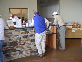 At the Visitor Center, we talked to an exceptionally nice and helpful set of interns - the absolute antithesis of Ranger Lynn from 6 years ago. Jessica Grow worked with us the most, but both of them strongly urged us to reconsider our plan for heading downstream along the Escalante. They indicated that below the point where Boulder Creek flows into the River (perhaps 40 river miles upstream of Coyote), the River was not safe to cross (Boulder was adding as much water as the main river was carrying at that point). Now my initial reaction to this was that it was another round of conservative Ranger talk, heightened in intensity by the recent drownings. And probably, my experience with Ranger Lynn colored by initial impression more than a bit. However, the interns' patience with us, as well as their helpfulness, won our respect and at least the consideration of a Plan B. (Had they shown us the data from the USGS water flow gaging station,
that showed normal flows in the Escalante being 5 - 10 CFS at this time of year, and that overnight, the flow had jumped from 10 CFS to 60 CFS, it would have probably taken less convincing on their part. Interestingly, by the end of May, when normal flows are on the order of 5 CFS, the Escalante was running at nearly 300 CFS. Such was the impact of the 300% of normal snowpack.)
At the Visitor Center, we talked to an exceptionally nice and helpful set of interns - the absolute antithesis of Ranger Lynn from 6 years ago. Jessica Grow worked with us the most, but both of them strongly urged us to reconsider our plan for heading downstream along the Escalante. They indicated that below the point where Boulder Creek flows into the River (perhaps 40 river miles upstream of Coyote), the River was not safe to cross (Boulder was adding as much water as the main river was carrying at that point). Now my initial reaction to this was that it was another round of conservative Ranger talk, heightened in intensity by the recent drownings. And probably, my experience with Ranger Lynn colored by initial impression more than a bit. However, the interns' patience with us, as well as their helpfulness, won our respect and at least the consideration of a Plan B. (Had they shown us the data from the USGS water flow gaging station,
that showed normal flows in the Escalante being 5 - 10 CFS at this time of year, and that overnight, the flow had jumped from 10 CFS to 60 CFS, it would have probably taken less convincing on their part. Interestingly, by the end of May, when normal flows are on the order of 5 CFS, the Escalante was running at nearly 300 CFS. Such was the impact of the 300% of normal snowpack.)
The dynamics of the ensuing debate among the nine of us backpackers may be interesting to psychologists, but this is not a psychology journal, so I will cut to the chase: After studying the maps covering 50 Mile and Davis Canyons at the Visitor Center, we came up with a potential alternative: Hike out 40 Mile Ridge trail to Crack in the Wall, descend, look at the river. If it is too high to cross, head up Coyote, come out and spend a few days in Davis and 50 Mile.
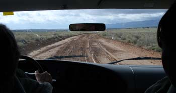 I hate abandoning a plan, and going into territory for which few of us had packed any maps (I had one - an old fashioned, USGS Quad, and Ray and Will bought a couple more) and no guide book support made me pretty uneasy. As we started down Hole in the Rock Road, my attention quickly shifted as we approached our first stretch of mud. Serious mud. To put things in perspective, we had learned at the Visitor's Center that the town had received 0.85 inches of rain over night. Now, in East Tennessee, this would have been a light shower. In this desert country, it was something like 10% of their total annual rainfall - in a 12 hour period. What we had ahead of us looked problematic. Not hugely deep, but slick as snail snot, as they say, occasionally rutted, and seemingly interminable. Except for breaks of suspension shattering washboard. Even our 4WD Highlander was fishtailing. I have no idea how Ray was able to keep the van on course. But I could see that with 20 mph being our top speed down the road, it would be a late night getting to camp. And to top it off, about the only thing that Susie hates more than mosquitos is mud on a dirt road. She was beside herself, and I was thankful to Andy and Sue for keeping her on the ragged edge of sanity while I focused on keeping the vehicle moving. It was by a country mile the worst mud, based on texture and distance, in which I had ever driven.
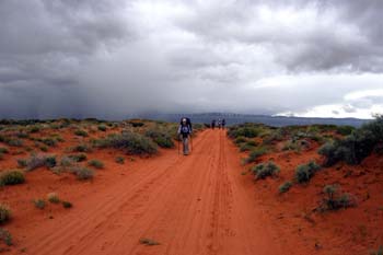 I am not sure exactly when it happened, but I think that by the time we had positioned the Highlander at Red Well (it had taken us two full hours from Escalante), squeezed into the van, and managed to move most of the way out to the official 40 Mile Ridge trail head, we had all mentally shifted to Plan B. Maybe it was the threatening rain, maybe it was the mud, maybe the desire for a more lightly loaded trip, but we all agreed when we arrived at our end of the Road that we would head for Crack in the Wall with four nights worth of food. This would offer the option of laying over a day at the confluence with the Dry Fork of Coyote. As we re-arranged our food and fuel, and tried to wolf down a bit of lunch, it started spitting rain. We could see that there were several showers in the area, and it would be only a matter of time before we were slammed. The mood was decidedly un-jubilant. No pictures, no jokes, just determination. Finally, it was time to hike.
We had left the van at 12:49 pm near a sign that warned of deep sand ahead. In retrospect, the rain dampened sand was easy to navigate, on foot or higher clearance vehicle. But we could not confirm such from where we had stopped, and we had plenty of experience with deterioration of canyon country tracks. We reached the official trailhead/parking area in about 30 minutes of steady walking, spurred on by the gathering showers. 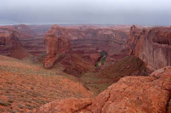 There is a strong path through the dirt that leads from the parking area, so route finding was zero problem. As we descended the slope, I could see up ahead someone moving on crutches. Uphill. As we passed this determined day hiker, I made a comment to her about motivation, since one of her legs was in a semi-cast. She sorta shrugged her shoulders, saying she had just wanted to take a short walk to enjoy the view. I would say that a four mile hike round trip over sand and slickrock on crutches suggests a very special kind of person. Maybe a nut case, maybe just dedicated. But I admired her spunk.
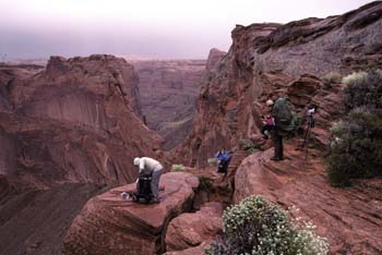
We hiked among flowers, the rain having stopped briefly. In a short while, we left the sand, and hit the mounds of slickrock that held lots and lots of small water pockets. Most of the crew (with the exception of Will, Barbara, and Ray) were ahead of me, and I simply followed their lead (since I knew the general direction we should be headed anyway). There were occasional cairns (really small ducks) that assisted with route finding, while winding up and down and around the slick rock mounds. We arrived at Crack-in-the-Wall at 2:20 pm, and I confess that I was a little blown away by the spectacular nature of the descent. Despite the brooding rain clouds, it was so dramatic. The swollen Escalante looked like a river of mud, and Steven's Arch, plainly visible, and the thin fins of rock reminded us all of just how rugged this country can be. I was feeling pretty good due to Andy's reporting that the actual descent spot (NAD27, 501378E, 4141169N) was less than a hundred meters from where I had estimated the descent from web reports and aerial photos. (Note that all UTM coordinates given here are in the NAD 27 CONUS grid, because that is what most paper topo maps still use. See Day 4.)
 Since the rocks were still wet with rain, and the clouds were blocking sun-driven evaporation, we decided to take a conservative approach and lower Sue into the first crack, since she could not see the footholds very well from this angle. Being the biggest guy in the group, I got the job of belaying her, not a big deal since it was not a big step. As it turned out, once Sue got down, she was able to direct many of us to the proper footsteps, without having to use a rope. We got a few of us down, and then started thinking through the process of lowering the packs. Had we had both segments of rope (I was carrying a 30 foot length of Goldline, and so was Ray, but Ray was not anywhere to be seen) or a longer single length, we might have been able to reach the bottom of the drop off in one fell swoop. However, with only 30 feet of rope, we had to lower packs over the first crack, then line them through another crack, using two people, and then eventually, lower them over the final pitch (getting packs through the final and narrowest crack would be pretty near impossible). About the time we got the six packs down the first layer and through the crack, these fine young gentlemen from the Brian Head area of Utah, hiking up out of Coyote Gulch, arrived and we offered to haul their packs up if they would help us lower our packs down. So we chatted while all this pack hauling was going on. The guys reported that the stream in Coyote really swelled as a result of the rain overnight. They were upstream a mile or two and had to wait until the water went down to safely cross. They were excited to show us photos from their digital camera that demonstrated the difference a couple of hours could make in the water levels in the creek bed.
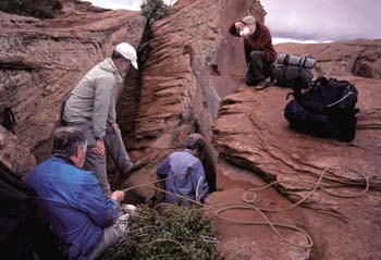 It took the six of us an hour or so to negotiate the cracks and lower packs. I was not concerned about the remaining three's ability to quickly get through, since they had a similar 30 foot rope segment. However, I was starting to worry that one might have slipped on the wet rock and hurt themselves. There was a bit of rain cloud lifting as we made the descent through loose sand. The route, with its views, was so spectacular that it required nearly 40 minutes to get to the bottom. (Halfway down, I turned around and saw the silhouettes of whom I thought was Will and Barbara, standing on the rim of the canyon, 150 meters east of the descent point. But where was Ray??) At the bottom of the descent, I showed Susie the rock ledge that our buddy John Thomas nearly slid off of in 1980, during our first trip down Coyote. However, we had already made the decision not to head down river, so crossing the ledge (most of us in 1980 had minimal problems) was not an issue. We headed up stream, past some folks who, Andy reported later, had told him in a thick accent that there were not any campsites upstream. Maybe they just wanted to have the place to themselves. I was a bit ahead of Susie, and walked through a couple of shady, flat spots, thinking, boy, if the creek did not look like Café au Lait, these would be good places to spend the night. I walked a bit further, and started hearing a trickle on the rock wall up ahead of me. After busting through some heavy brush, I saw a nice spring flowing down the side of a rock slope. I knew we were here for the evening. I got back to what would become our camp, and I think it was Robin who reported that she had been able to yell up to Will, who had indicated that they had waited out the rain until 2:45 pm, and they Ray realized he had forgotten to pack his rain gear. So he was going to drive up Hole-in-the-Rock road (in the awful mud??) And buy some rain gear in Escalante, and then come back and meet us at the upper end of Coyote. I wondered to myself what sort of rain gear one could buy in such a small town and I thought to myself that Ray must be pretty disgusted with himself.
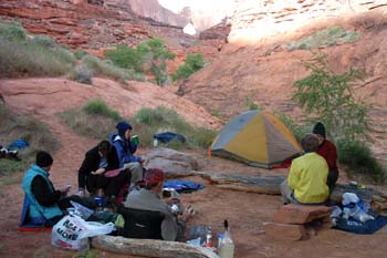 It was a pretty nice, albeit well used, campsite. And it had a great view of Steven's Arch. At Susie's suggestion, we set up our tent to take advantage of the view, but Susie, taking another opportunity to highlight the Sierra Designs Hyperlight AST's provision of totally inadequate accommodations, pointed out that only I would have the view of the arch, since the short person's side had no door and no ventilation. She was right about the door and the much-smaller-than-originally-advertized size, and not being able to win this argument, quickly suggested a bath at the spring. The spring did require funneling water off the rock face with something like aluminum foil, but it was cold, clear, did not need treatment, and it sure beat the thin mud coming down Coyote. Eventually, the remainder of the crew (sans Ray) arrived in camp, and dinner was nigh. Thank goodness. Such always affords the opportunity to relax and laugh about the day's frustrations and bad weather. We all wondered what sort of rain gear Ray could possibly find in Escalante, given his penchant for thriftiness (it's like: sure, you can buy a $500 Goretex rain suit, but what can you get for $20??). Anyway, during dinner, we noticed three fellows coming down the rock face that is the short cut (heading downstream Coyote) from the River. (It is the route that is taken if the mouth of Coyote is flooded, and you need to go up the Escalante.) They stopped by our camp, and reported that they had waited for several hours at the mouth of Stevens Canyon for the river level to decrease. It did only a little bit, and it was getting late in the day, so they went ahead and crossed. They told how as they entered the river, it was "only" knee deep, but running hard. But as the continued to cross, the water first reached their waists, and then upper chest, and by this time, they were dog paddling, in an effort not to be washed downstream. The eight of us concluded that we had made a good decision (not attempting to cross the river) and leave the original plan for another year. Sometimes, you just get lucky and do the right thing.
© Roger A. Jenkins, 2005; Crack in the Wall photos © Suzanne A. McDonald, 2005; Visitor center and mud driving photos © William H. Skelton, 2005