
Side Canyons of the Lower Escalante 2005
Descent into Fifty Mile
Friday, April 29
 No rain at all last night, and
it was good sleeping weather. We had an uneventful packing up, and
were all out of camp by a little after 9 am. We took the official
stock route all the way up, and were able to confirm that the set of
cairns that I did not see were the official "stock route" (read, even
stupid cows can do this) into Davis Gulch. I took a waypoint 12S,
504052 E, 4127975 N, at the last - or top -cairn, so people using this
write up as a guide should use this point as the key to finding the
way into the canyon with ease. Yeah, it is a little bit steep, but
there is a section of slick rock that has been blasted to flatten it,
and if the cows can do it, you can too. (We also confirmed that the
set of cairns I had found a couple of days previously, are, in fact,
the so-called friction route. Probably not recommended for
backpackers.)
No rain at all last night, and
it was good sleeping weather. We had an uneventful packing up, and
were all out of camp by a little after 9 am. We took the official
stock route all the way up, and were able to confirm that the set of
cairns that I did not see were the official "stock route" (read, even
stupid cows can do this) into Davis Gulch. I took a waypoint 12S,
504052 E, 4127975 N, at the last - or top -cairn, so people using this
write up as a guide should use this point as the key to finding the
way into the canyon with ease. Yeah, it is a little bit steep, but
there is a section of slick rock that has been blasted to flatten it,
and if the cows can do it, you can too. (We also confirmed that the
set of cairns I had found a couple of days previously, are, in fact,
the so-called friction route. Probably not recommended for
backpackers.)
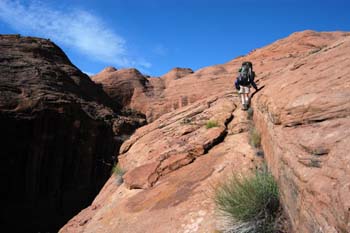
The point that the NPS had marked "Steep" on their quad suggested that
we move in a NNW compass bearing from the point that we exited the
Stock Trail, so that is what we did. Even with stops to examine an
enormous amount of Moqui Marbles 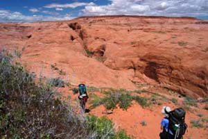 on
the mesa top, and photograph each other and Navajo Mountain (it was a
lovely, cool morning), it only took us about 2 hours to get to what
amounts to the upper rim of 50 Mile Creek Canyon. From the point where
we stood (12S, 503225 E, 4129687 N), it was clear that the NPS point
of descent was out in the middle of a large jumbled bowl of slickrock,
and the actual descent route was not really visible. So it was time to
send out scouts. After all, one person's concept of "steep" could be
another person's idea of "impossible" or, at least, "life
threatening." (We also knew that Kelsey has another recommended way of
getting into 50 Mile further up canyon on a sand slide, but to get
from where we were, to the top of the sand slide would mean another
hour or two of route finding in the sun.) So Sue and Ron, acting as
scouts, took off. Will followed them, carrying his backpack,
optimistically thinking that if the Park Service was featuring this
route, it could not be too bad. He also could act as an intermediary,
relay voice messages from the scouts who were out of sight for a long
time.
on
the mesa top, and photograph each other and Navajo Mountain (it was a
lovely, cool morning), it only took us about 2 hours to get to what
amounts to the upper rim of 50 Mile Creek Canyon. From the point where
we stood (12S, 503225 E, 4129687 N), it was clear that the NPS point
of descent was out in the middle of a large jumbled bowl of slickrock,
and the actual descent route was not really visible. So it was time to
send out scouts. After all, one person's concept of "steep" could be
another person's idea of "impossible" or, at least, "life
threatening." (We also knew that Kelsey has another recommended way of
getting into 50 Mile further up canyon on a sand slide, but to get
from where we were, to the top of the sand slide would mean another
hour or two of route finding in the sun.) So Sue and Ron, acting as
scouts, took off. Will followed them, carrying his backpack,
optimistically thinking that if the Park Service was featuring this
route, it could not be too bad. He also could act as an intermediary,
relay voice messages from the scouts who were out of sight for a long
time.
 Sue and Ron were gone for
nearly an hour. We yelled down to Will, standing maybe 250 feet below
us, asking him to provide some feedback. He eventually yelled back:
SUE SAYS: WE NEED TO TALK ABOUT IT!! That did not sound encouraging,
for sure. When Sue and Ron returned, she explained that she THOUGHT we
could make it. The route was a long and very steep slab of slick rock,
made more tolerable (read do-able) by little fractures and foot-bed
width layers of rock. But the trick was whether we could get down this
crack that came after the steep slickrock, and was the key to getting
on a bench that would take one to the canyon floor. However, with two
30-foot pieces of rope, we should be able to belay both people and
packs down the crack, and we should be ok. It was at that point that
we looked around at each other's backpacks, and said TWO 30-foot
sections?? Sue was carrying one length, but the other length, probably
being carried by Susie, was left at the van on Wednesday morning,
thinking we would not need it any more. I felt badly, because I should
have been paying closer attention. So we would have to do this with
one length of gold line. Never a dull moment.
Sue and Ron were gone for
nearly an hour. We yelled down to Will, standing maybe 250 feet below
us, asking him to provide some feedback. He eventually yelled back:
SUE SAYS: WE NEED TO TALK ABOUT IT!! That did not sound encouraging,
for sure. When Sue and Ron returned, she explained that she THOUGHT we
could make it. The route was a long and very steep slab of slick rock,
made more tolerable (read do-able) by little fractures and foot-bed
width layers of rock. But the trick was whether we could get down this
crack that came after the steep slickrock, and was the key to getting
on a bench that would take one to the canyon floor. However, with two
30-foot pieces of rope, we should be able to belay both people and
packs down the crack, and we should be ok. It was at that point that
we looked around at each other's backpacks, and said TWO 30-foot
sections?? Sue was carrying one length, but the other length, probably
being carried by Susie, was left at the van on Wednesday morning,
thinking we would not need it any more. I felt badly, because I should
have been paying closer attention. So we would have to do this with
one length of gold line. Never a dull moment.
 We snarfed lunch up, and
started the descent for real a bit after noon time. The first 250 feet
of descent is just no problem. One heads essentially NNW, and then
makes a sharp turn to the right and enters the slickrock bowl. (At
this point, you are directly across from the cut that 50 Mile Creek
makes to its left and enters some narrows. This cut is pretty
distinctive.) I am not sure that "challenging" is the best way to
describe the bowl. But you have to pay a lot of attention to foot
placement, and staying on a route that is the path of shallowest
descent. Will and Ron sorta stood by at key points on the descent,
acting like traffic cops directing each of us toward the spots that
offered the shallowest and safest route. I think at this point, one
has to have supreme confidence in the laws of physics, and boots that
can grip the slickrock well. The boot-width "ledges" make the route
doable, or at least, makes one believe that the route is doable. But
it is also true that this route is just about at the edge of what a
backpacker is likely to feel comfortable with. Unfortunately, lacking
perhaps three hundred meters of rope, there is no good way to belay
people across this bowl. However, if one were to slip and fall, as
long as you don't roll (hard to do with a big pack on one's back), it
would seem as though you would not go too far. In other words, unlike
the route we pioneered into Lower Grand Gulch in 1985, one slip does
not mean that you need to bend over and kiss your ass goodbye.
We snarfed lunch up, and
started the descent for real a bit after noon time. The first 250 feet
of descent is just no problem. One heads essentially NNW, and then
makes a sharp turn to the right and enters the slickrock bowl. (At
this point, you are directly across from the cut that 50 Mile Creek
makes to its left and enters some narrows. This cut is pretty
distinctive.) I am not sure that "challenging" is the best way to
describe the bowl. But you have to pay a lot of attention to foot
placement, and staying on a route that is the path of shallowest
descent. Will and Ron sorta stood by at key points on the descent,
acting like traffic cops directing each of us toward the spots that
offered the shallowest and safest route. I think at this point, one
has to have supreme confidence in the laws of physics, and boots that
can grip the slickrock well. The boot-width "ledges" make the route
doable, or at least, makes one believe that the route is doable. But
it is also true that this route is just about at the edge of what a
backpacker is likely to feel comfortable with. Unfortunately, lacking
perhaps three hundred meters of rope, there is no good way to belay
people across this bowl. However, if one were to slip and fall, as
long as you don't roll (hard to do with a big pack on one's back), it
would seem as though you would not go too far. In other words, unlike
the route we pioneered into Lower Grand Gulch in 1985, one slip does
not mean that you need to bend over and kiss your ass goodbye.
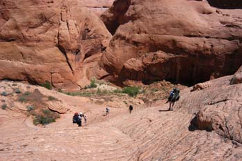
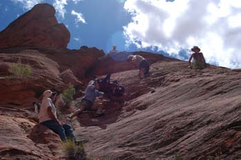 We all made it to the bottom of
the bowl in one piece. The next and final obstacle was the seam or
crack, perhaps a couple of 100 - 150 meters upstream of the bowl. Sue
had indicated that there was a bit of exposure, but felt this group
could handle such. In retrospect, it was interesting how effortlessly
we set up a team of people, each using their best skills, to get packs
and people to the bottom. (We later mentioned this to Robin, and in
contrast to the Outward Bound experience she had, we all had been
hiking together for so long that setting up a team to do this just
happened, because we all knew what each other's skills were.). My
"skill," in this case, was that I was the biggest guy on the trip and
an obvious choice to belay packs and people. As I look back over the
photos, it was quite an operation, and the crack looks pretty darn
steep. The ledge one has to traverse has some exposure, and while a
full belay is overkill, it is nice to have a rope to hold on to as one
traverses the ledge. So the first thing we did was shuttle the packs,
by means of a rope, across the ledge. Sue and Andy would move the
packs over to Will, and then once tied up, he would swing them out
into the crack. Ron would grab the pack, who would hand it downslope
to Ray, who would shuttle down to Robin and Susie, who would stage the
packs out of the way. This had, of course, required getting people
into position, by the aforementioned rope hand hold. It was a pretty
interesting process. Occasionally, when one of the humans would go
down the crack, rocks would dislodge, the word "ROCK" was yelled at
the top of the lungs, and the people below, typically Robin and Susie,
would scatter like pigeons. One time, it seemed like one rolling rock
was determined to chase Susie all the way to the canyon floor. But she
ducked behind a large boulder at the bottom of the crack and avoided a
very nasty collision.
We all made it to the bottom of
the bowl in one piece. The next and final obstacle was the seam or
crack, perhaps a couple of 100 - 150 meters upstream of the bowl. Sue
had indicated that there was a bit of exposure, but felt this group
could handle such. In retrospect, it was interesting how effortlessly
we set up a team of people, each using their best skills, to get packs
and people to the bottom. (We later mentioned this to Robin, and in
contrast to the Outward Bound experience she had, we all had been
hiking together for so long that setting up a team to do this just
happened, because we all knew what each other's skills were.). My
"skill," in this case, was that I was the biggest guy on the trip and
an obvious choice to belay packs and people. As I look back over the
photos, it was quite an operation, and the crack looks pretty darn
steep. The ledge one has to traverse has some exposure, and while a
full belay is overkill, it is nice to have a rope to hold on to as one
traverses the ledge. So the first thing we did was shuttle the packs,
by means of a rope, across the ledge. Sue and Andy would move the
packs over to Will, and then once tied up, he would swing them out
into the crack. Ron would grab the pack, who would hand it downslope
to Ray, who would shuttle down to Robin and Susie, who would stage the
packs out of the way. This had, of course, required getting people
into position, by the aforementioned rope hand hold. It was a pretty
interesting process. Occasionally, when one of the humans would go
down the crack, rocks would dislodge, the word "ROCK" was yelled at
the top of the lungs, and the people below, typically Robin and Susie,
would scatter like pigeons. One time, it seemed like one rolling rock
was determined to chase Susie all the way to the canyon floor. But she
ducked behind a large boulder at the bottom of the crack and avoided a
very nasty collision.
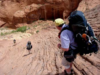
The last piece of the puzzle was to get me, the belayer, down. Will is
our only knowledgeable rock climber on the trip, so we voted to have
him belay me down and he would have to make it down on his own. Which
went quite smoothly. We were all down to the bottom of the slot (12S,
503068 E, 4130152 N) by 2:15 pm, so it had taken us two hours to do
the entire descent, handling nine packs and nine people, once we got
through the steep slick rock. (Anyone reading this who is interested
in doing the trip, there are more photos here that can provide
additional detail on the descent route.) We set up camp about
150 meters upstream of where we got to the bottom. 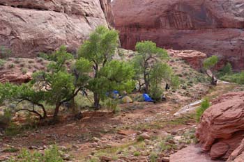 It was not real grassy, but it had enough flat spaces
and a couple of cottonwoods provided shade. Susie really liked it,
because it was nice and close to the water, and such was crystal clear
and offered wonderful rocky places of bathing in the sun. Heaven on
earth!!
It was not real grassy, but it had enough flat spaces
and a couple of cottonwoods provided shade. Susie really liked it,
because it was nice and close to the water, and such was crystal clear
and offered wonderful rocky places of bathing in the sun. Heaven on
earth!!
The rest of the afternoon was spent poking around, and taking care of chores. We did some climbing up through a tumble of rocks across from camp, and Sue found a very interesting inscription in the canyon wall: "E. Ruess Hunters, 1935" and then a bunch of names. Obviously, folks out looking for the never-to-be-found Mr. Ruess. Dinner was our homemade Santa Fe chicken and rice, and we built a small trash fire at the edge of the stream bed (thinking such is not illegal in 50 Mile. If it is, we apologize.) and sat out and watched the stars and chatted until it was way past time to crawl into our sleeping bags.
© Roger A. Jenkins, 2005; Close up of hikers descending photo © William H. Skelton, 2005