
Side Canyons of the Lower Escalante 2005
Strolling up Coyote
Monday, April 25
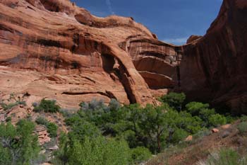
 Coyote Gulch is certainly the stuff of legends. It has to be one of the most sublime routes I have ever taken. This would be the fourth trip in it for Andy and me, and it has not worn thin. It is like a long, narrow, Garden of Eden, with its cottonwood trees, splashing stream, arches, pools, wildflowers, etc. The hiking is very easy (one reason why it is so popular) and the climate pleasant at this time of year. I awoke at 6:30 and Susie seemed rarin' to go. We were up before everyone else, and such is a good thing, since she and I usually require the longest to break camp. Our goal today was a campsite a relatively short 6 or 7 miles upstream, just above the mouth of Hurricane Wash. But she and I, knowing (it was her third trip here) the number of distractions along the route, knew it would take a full day. The weather was also vastly improved (connection?), and it promised to be a good day, granting that we really could not see much of the sky. Pleased with our progress, Susie and I pulled out of camp at 9:08 am, thinking we were first. But when we passed the upper camp area our group was using, Will's tent was gone. Will??!! The FIRST one out of camp?? Unbelievable. Actually, he was hiking without a partner on this trip, and he had severely sprained his ankle jogging about a month before the trip, and things don't heal as fast as they did 20 or 30 years ago, so he wanted to be out of camp early to give himself plenty of time.
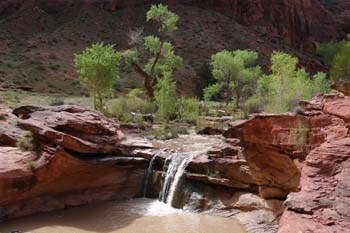
 It was nice and cool in the morning, and many of us wore long pants. We picked our way around pools, and carefully probed for the quicksand that we knew had to be present, right after such a heavy flood. About a mile upstream under a huge overhang on canyon left, we ran into the guys that had come through our camp last night. They decided, after hearing from us how bad the road was, not to attempt to get all the way out last night, but to give Hole-in-the-Rock road another day to dry out. Wise idea. We crossed several pools as we moved up the creek bed, paying more close attention that usual, because the water was so cloudy. You really could not tell the depth of the pools, or even the creek bed, for that matter. Our first serious obstacle (recall that this was the first time any of us had backpacked upstream here, so it all felt a bit different) was a large waterfall/pour off a maybe a mile and a half up from camp. Some of our party had passed Susie and I, and tried to get up around it (and, with work, you can), but several of us took the backtrack and climb approach. There was a wonderful spring running off the wall (canyon right), and I had hoped to collect some drinking water as we passed over it on our traverse. But alas, it was running underground when we crossed (this same spring had been a real bonus, and was running on the surface, when we crossed it up high the first time in 1980). But the view of the pour-off (with a huge flow over it) and a great blooming claret cup cactus was worth the effort to climb around. Above that, it was more waterfalls, pour-offs, huge overhangs, and pretty soon, Cliff Arch. Susie and I both looked at each other and said: "Have we seen that before??!!" (The quick answer, after reviewing our photographs from our trip 13 years ago was yes, we had seen it before, but I guess it just felt different heading in the other direction, or something.)
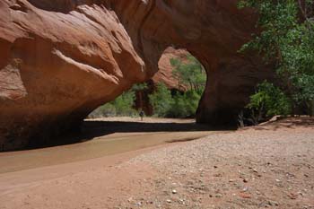 We all stopped for lunch, at a little side creek from which clearer water could be obtained downstream of Coyote Natural Bridge, around noon (obviously taking our time, photographing and goofing off). We speculated in the shade as to the exact location of the pictographs we had seen on our Y2K trip and so after lunch, many folks (especially those who had not seen them previously) climbed up the huge sand slides and eventually were successful. Susie and I decided to push on, because we knew, at the pace we had been making, we would not make camp before dark. So pretty quickly, we came to the Bridge, and we both photographed each other silhouetted against the bridge. We could see Ron back a ways, also taking pictures, but then, we were on our own.
The next figure-it-out place was a narrows that we remember from times before: it has a tree trunk wedged in the top of it. By the time I arrived, Susie had already probed the edges of the pool with her hiking stick, and was uncertain how to proceed, since the water, while visibly better than this morning, was still too cloudy to see the bottom. We opted to climb up and around on canyon left, avoiding potential quicksand, but Will reported later that he was able to get through the pool with no problem.
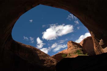 Susie and I stopped at a delightful spring, just downstream and canyon right of the downstream side of Jacob Hamlin Arch, that we remembered from our Y2K trip. Since we had been here before, small privies have been installed, an indicator of the unfortunate popularity of this place. The privies are open air, and consist of a toilet seat on top of a vertically mounted culvert pipe. I guess that in popular camping areas within the canyon, it is a good idea to concentrate the toilet area. The veterans of the first group Escalante trip (myself, Andy, and Will. Ray was also on that trip, but not with us at this point) discussed later that day how much had changed in 25 years. First was the amazing number of guidebooks, paper and digital maps, aerial photos, and internet reports available for trip planning. Back then, all we had for information was a hand-drawn map by the Park Service, showing approximate distances and potential camps along the river, and 1:63,000 scale paper topo maps. But also, there were vastly fewer people. 25 years ago, we saw a couple of parties in Coyote, and then, along the river, we saw one hiking party and one kayaking party in nearly a week of travel. People are clearly starved for wilderness recreation opportunities, and it always blows me away that there are land managers who actually believe that we do not need any more protected Wilderness areas.
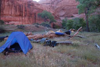 It was now time to start thinking of finding a campsite. Our goal was the place that we had used several times previously, just up through the narrows of Coyote that are immediately above the mouth of Hurricane Wash. There were plenty of parties in the canyon, so good camping spots were something you wanted to get early in the day. We passed a really nice bench with lots of grass and some shade below Hurricane at 3:23 pm, and then couple of camps people had established right across from the mouth of Hurricane. The water coming down Hurricane was nice and clear, and thus, it would be good to be able to use that water. However, when we arrived at our planned spot, there was a couple that had just arrived a few minutes before us, and clearly did NOT want the company of eight other hikers, even if it was a big campsite. So Susie and I turned around, thinking that we would try to get back to the grassy bench before anyone else claimed it. The bench (12S, 495287E, 4141202N), a seven minute brisk hike below the mouth of Hurricane, was unoccupied when we arrived, so we claimed it. It had some trees, good access to bathing water, old logs for spreading out laundry, and was within decent walking distance of a potable (after treatment) water supply. As members of our crew began to arrive, all expressed approval of the site, and it seemed that folks thought it was better than the one we had originally planned to be at. The last chick, Will, nursing his ankle, was in the nest by 5:20 pm. It had been a really delightful day, with opportunities to really savor Coyote Gulch. Everyone was in a good mood, and most of us stayed up past dark chatting.
© Roger A. Jenkins, 2005