
Wolverine Creek to the Upper Gulch
Saying Goodbye to the Escalante
A Toasty Horse
Sunday, April 29 Breakfast at the motel restaurant took forever. There was only one woman who was handling waiting tables and cashiering. This being prime season in the area, the restaurant, as was the motel, was pretty packed. But no matter, we got out of town about 8:10 pm. Barbara had left a bit earlier and drove over to Boulder, to see if she could find a spot to park her car, so she would not have to leave it unattended at the trailhead. She had her car packed with belongings, since her original plan was to leave the Research Center, come to Bozeman with us, and start working as a hostess in the Lake Hotel in Yellowstone. She did find someone to keep an eye on it, which was good.
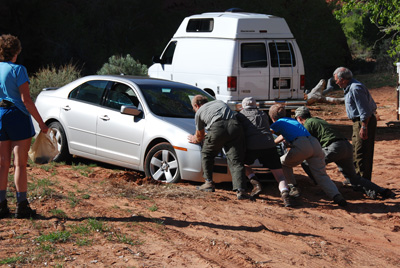 But then the little errors started creeping in. Last night, Ron realized that he had left his 6th and 7th days' worth of food (the Upper Gulch part of the trip) sitting on the table back at his home in Tennessee. Then, as we got out to the trailhead, he realized that he left his trekking pole back in the motel room in Escalante. OK. Next, when Will pulled into the non-official trail head parking area at The Gulch, he "forgot" that the car he was driving had front wheel drive, and he backed in such that his drive wheels were over an incredibly sandy spot. Before we could do or say anything, this spinning front wheels had dug huge channels in the sand, and he had sunken the car to the frame. Boy, the old farts go backpacking .......
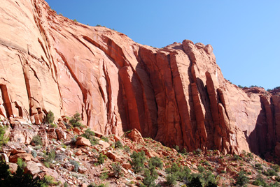 It is about 18 miles out the Burr Trail out to the point where the Wolverine loop road takes off to the south, and then about 10 miles south to the Wolverine Creek trail head. A word about the road conditions: most of the Burr Trail is now paved (which was not the case in 1986), and it is very smooth going. However, I can see why the Park Service advises not to even consider driving the Wolverine Loop road after a rain, even if you have a four wheel drive. The stretch where the road crosses the broad wash that becomes upper Horse Canyon is very sandy, and would be tricky if it were muddy. Also, the last few hundred meters of road to the Wolverine Creek trailhead has, or had, at least this time of year, a creek running through it. A small sedan could deal with the amount of water on this morning, but much more would be a problem, and after a rain...... well, it would not be pretty.
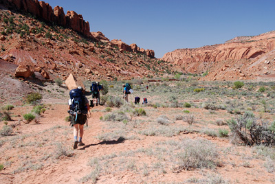 The forecast for this day was warm: low 80's, which can be hot in the desert, so we were glad that the smooth Burr Trail afforded an earlier than expected start. We hoisted packs at 10:39 am, after the usual 20 - 30 minutes of farting around at the trailhead. The new permitting process (just write your permit at the trailhead) is convenient, but with a large party, and multiple cars, campsites, etc, it takes a while to fill out. If you look on Google Earth (a great backpack planning resource if the coverage is sufficiently high resolution), you can see that the first couple of miles from the trailhead, you are in a large open wash. There are walls, but they are sufficiently far away that it does not feel much like a canyon. The walking is easy, and the primary distraction is the vast number of huge, tree-trunk sized chunks of petrified wood. Quite amazing. Certainly, the highest concentration of large pieces I have ever seen. We stopped for a break at 11:50 and the GPS indicated we had already made nearly 2.5 miles. That indicates how easy the hiking is. But once we got to the confluence with the south fork of Wolverine, the route becomes much more narrow, sandy, rocky and the hiking speed slows way down. Of course, more photos are in order.
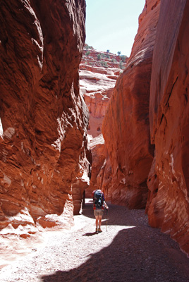
After the 10 minute break, another 35 minutes and creeping hunger forced Susie and I to stop under a large overhang on canyon left for lunch. Will and Kim joined us, and we four enjoyed the cool shade. We left the lunch spot at 1:10 pm, enjoying the intermittent trickles of water in the stream bed as the canyon tightened up. But I would not count on this water to be there in any but the wettest seasons. The narrows of Wolverine are nice and sinewy.  In many places, they get as tight as 6 feet. The guidebooks say something about the fact that early packers had to take the loads off the horses or pack animals to get them through these narrow stretches. Lots of nice photographic opportunities in this stretch, but Susie and I kept pushing, since we could feel the day warming up.
You turn a corner and bam, you are at the mouth of Wolverine, and the broad expanse that greets you says: Big, wide, hot, dry, and sandy. I must say, given the heat, the first 20 - 25 minutes or so in Horse was quite unpleasant. It was so dry and sandy that it was tough to get any purchase with one's boots. You step in the sand, and it just pushes away when you try to move forward. Despite Susie's new lightweight Osprey Ariel 65 (Finally!!! A pack that actually fits her and can almost carry all of her gear!!), I could tell she was dragging. We stopped a bit after 2:30 in the shade of a small cottonwood, had a bite to eat, and more water. I could tell that it helped both of us. What helped even more was the realization that we were less than a mile from our projected campsite. I figured we could gut it out for that short distance, especially with the promise of a spring, trees, and green grass.
 OK, so two outta three ain't bad. The point I had decided looked like the best place to camp (based on the topo map, guide book, and Google Earth) is near an old line cabin on a bench on canyon right, a few hundred meters after the point where water starts to flow in Horse. For those of you who like to be a bit more exact about places, the GPS waypoint is 12S, 477158 E, 4177175 North. (Note that as usual, all the waypoints I report in this write up are in NAD27 coordinates, to maintain compatibility with paper topo maps.) We pulled into camp at about 3:30 pm, slowed from the heat. The campsite did have lots of grass, and some highly needed shade, but no spring on the bench. At least, none that any of us could find, and we looked. Hard. But no matter: The point where water started to flow was only a couple of hundred meters above camp, and you could tell, by the green fuzz growing on the side of the flow, that this was permanent water. It looked like a spring, tasted like a spring and was certainly sufficiently cold to be a spring. It is just that it was flowing from the side of the canyon floor. Hey, it worked for me.
We spread out our camping location, arranging our tents for the promise of shade. When one is with this size of a crew (11 people, comprised of 3 couples and 5 singles), finding spots sufficiently large for 8 tents can be a challenge. One or two tents can find a home almost anywhere. But find homes we all did. 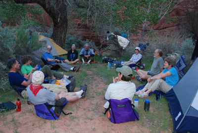 We all cleaned up at various times, usually downstream of the camp and above the water line. I had replaced my trusty racing flats with Crocs for camp shoes. The advantages to Crocs are their low weight, and ability to get them wet without living with wet feet. The disadvantage, at least in a canyon setting, is that one is always getting sand in them. Also, in a pinch, they really would not double as hiking shoes. But, they are lightweight. And colorful!! Dinner did not start until around 6 pm, when the sun dropped below the canyon wall. Susie and I had a Kroger cajun rice with some beans and some dried ham. We noted that the dried spiral sliced ham really re-constituted nicely. Certainly better than eating chewy ham. The after dinner entertainment was the usual chatting, and commenting on the mistakes made this day. No major problems, just good humored chiding. We concluded it would be a warm night after noting that the temperature had barely dropped back into the 60's by nightfall. And so it was.
To view supplemental photos of this trip, go to our TwoHikers PicasaWeb gallery.
© Roger A. Jenkins, 2007