
Wolverine Creek to the Upper Gulch
Saying Goodbye to the Escalante
Bypass
Wednesday, May 2
 I felt good when I got up. Part of it was the fact that we were not the first ones ex tentia. Secondly, the Euflexxa seemed to be working. It has been recommended by one of the orthopedic surgeons with whom I had been working since I had ground my left medial meniscus to a pulp skiing in British Columbia in February, 2006. Euflexxa is a synthetic version is the lubricant that is supposed to be in the knee joint. Some of us now need more of such, since we no longer have the joint padding we were born with. Anyway, my sorry-ass left knee seemed to be doing pretty well, with no more than the usual stiffness at the end of the day. We were out of bed a few minutes before 7 am, and left camp by 8:50 am. The usual 2 hours to break camp. Our goal is to not be too far behind Sue and Andy, even though they usually have many more complex breakfasts than we do. This morning, we were ahead by a couple of minutes. Not sure what it is, but it seems to me that couples take a bit longer to break camp than singles. Ah, another mystery of life....
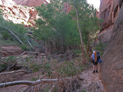
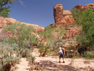 We had told A&S about the little alcove we had found yesterday that required a climb up. Andy later reported that they were seduced by it as well. Andy indicated that he was able to get up the pour-off, but Sue's legs were simply not sufficiently long to make the big steps. Meanwhile, once past the two seams on canyon right, The Gulch seems to narrow down a bit, and the damage from the flood becomes more apparent. Whole groups of cottonwoods pushed over, a lot of sand moved. In some places, it was necessary to go tight against one wall to make forward progress. Speaking of making forward progress, I sometimes think that our group acts like a giant centipede, with many pairs of legs, each doing their own thing, but the unit as a whole moving in the right direction, in this case, up canyon. After about a mile and a half or so above camp, the level of flood damage seemed to ease up a bit. I had the sense that we were spending more time hiking and less time just avoiding debris. We stopped after about 90 minutes for a break in a particularly verdant section of the canyon, with nice shade and big dramatic walls. A&S and Kim and Will caught up to us about that time. The Gulch is a lovely spot, and I did not mind repeating the route that we had done 21 years ago.
We got to the very short stretch of narrows, where there is a tree trunk wedged in across the span of the canyon walls. I had been wondering if it would have survived the flood, but to me, it looked like it was wedged in even tighter. We all took photos with one or more people under the log, but the lighting was not great in this spot at this time of day, due in part to the leaves of a large tree that had been partially torn down in the flood. So we moved on, knowing that Halfway Hollow, and the real Gulch Narrows, was just up ahead.
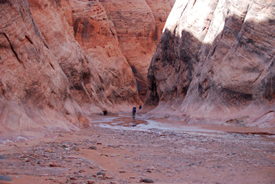
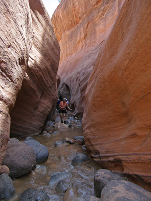 We pulled into the mouth of Halfway Hollow just a few minutes short of noon time. Ah, what a difference 21 years makes. In 1986, we had come from our campsite along the river (perhaps a third of a mile below the one we left this morning), had visited the narrows, photographed, got all our packs and us up above the first obstacle, and had lunch as we topped out on the bypass climb. This year, we would eat lunch at the mouth of the Hollow. Must of been the debris in the canyon. Couldn't be due to the aging of our bodies. We got up into the Hollow only a very short distance and were stopped by a couple of big pools that would have required swimming just to see the big pour-off. Given the time, it seemed more prudent to get on with the bypass. But of course, before beginning the bypass, one has to go up into the narrows and see what it was that we were bypassing. The actual narrows are pretty tight, 10 - 12 feet in places, and there are lots of slippery rocks in the bottom, making footing precarious. The narrows seem to go on for several hundred meters, before ending in a falls that seems tantalizingly low. It feels like you could almost climb it. I remembered the break in the falls (where the water flows vertically) being much higher in 1986. I figured what had happened was that the flood of 2006 dumped a veritable pile of sand at the bottom of the pour-off, like it did everywhere else. Or maybe my memory was just failing. But as it turns out, there was nothing wrong at all with my memory. In a post-trip comparison of photos taken in 1986 and photos taken this year, the falls break is clearly much lower now. It is really quite astounding to see this change. In another few decades, there will be no need for a bypass. One will be able to just walk up the falls.
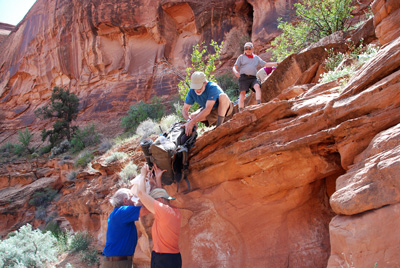
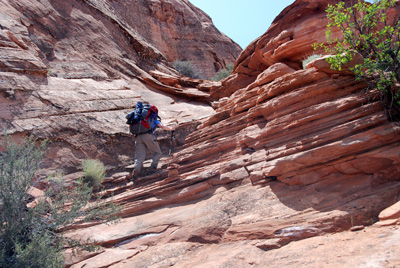
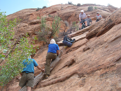
Everyone seemed to have taken all the photos they wanted, and it was time to get serious about bypassing the narrows and falls. For some reason, many of the crew had carried their packs further up into the narrows, thinking, I guess, that the start of the bypass was further upstream. Actually, the start of the bypass route is maybe a couple of hundred meters (at the most) upstream of the mouth of Halfway Hollow, near 12S, 473701 E, 4179036 N. If you look carefully on Google Earth, you can see the paths being made by hikers as they cross the first bench. We saw a large cairn near the place where it is most obvious to turn uphill, near the aforementioned waypoint. As the EPA likes to say: "Your mileage may vary." So we climbed the first bench, and it was only then did I recall that the first obstacle is getting up to the top of the second bench. Essentially, you walk along the hiker path for a short distance, and come to a crack/seam in the wall to your left, and yes, that is what you have to go up. The first thought that will come to mind is that it is going to be tough climbing up in the seam with a pack on, and you will be correct. Much easier to take off the packs and hoist them up to a person who has already climbed up through the crack. (If you are hiking solo, here is where you pull out that 50 feet of parachute cord you carry, tie it on to your pack and hoist the pack up after you have climbed through the seam. All this climbing, and hoisting packs, and dumping them takes time. A lot of time. It seemed that on this trip, we had to hoist the packs somewhat higher (maybe 8 - 12 inches or so) to the person above. I attributed such to sand that had blown away, making the standing spot lower. But maybe it was just age. Of the participants, not the canyon.
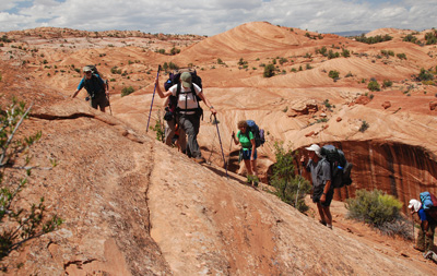
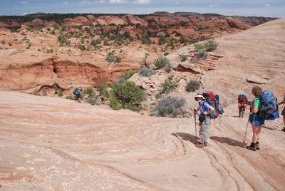
 OK, having hoisted the packs over the first obstacle, it was time to get on with climbing. Susie and I took of on the obvious path along the bench that goes upstream for at least a couple of hundred meters, but starts to curl over to the left, eventually leads to a large slab of tilted slickrock. Susie climbed up through the obvious steep notch with the required scrambling and seemed to be doing pretty well. From that point, the route cuts to the right for a few meters, and begins to ascend another slab of tilted slickrock. The preferred route (ie, the one that has the most shallow slope to it) then cuts back hard to the left and traverses maybe 20 - 25 feet of steep slickrock over to a seam that has a more gentle climb. I crossed the slope with no problem, but Susie hiccuped. She said she was just having a hard time due to the exposure. Now, it was not like she had never dealt with steep slickrock with a large pack before. Frankly, what we descended into 50 Mile Creek was much more discomforting, shall we say. But everyone has good days and bad days on slickrock, days when you feel like your feet simply can not slip, no matter how steep the rock, and days when you feel like your feet are covered with ball bearings. Sometimes, the mind does conquer matter, and gets you to question what you KNOW you can do. Well, it was pretty clear that this was the easiest route up, and yes, there was a bit of exposure, but it was not too bad. As long as your head was not playing games with you.
 I dropped my pack at a convenient spot (that is, where it would not roll off into oblivion) and came back and escorted Susie. Many of us, when we get "buffaloed" on the slickrock, try to lean into the slope, rather than standing up straight. Such is not wise because it puts a sideways force vector on your support point (your feet) and it is much easier for the feet to slip. That is what Susie was doing, but I was not about to let her dislodge me, and we got across without incident. Sue climbed past me, got up to a more stable spot, and helped Susie the rest of the way up, while I stood down below and directed traffic across the slope. In a few minutes, we were all on flat sand, essentially at the top of our climb. Here is a link to a Google Earth photo which shows the approximate route we took. It might be useful to some readers.
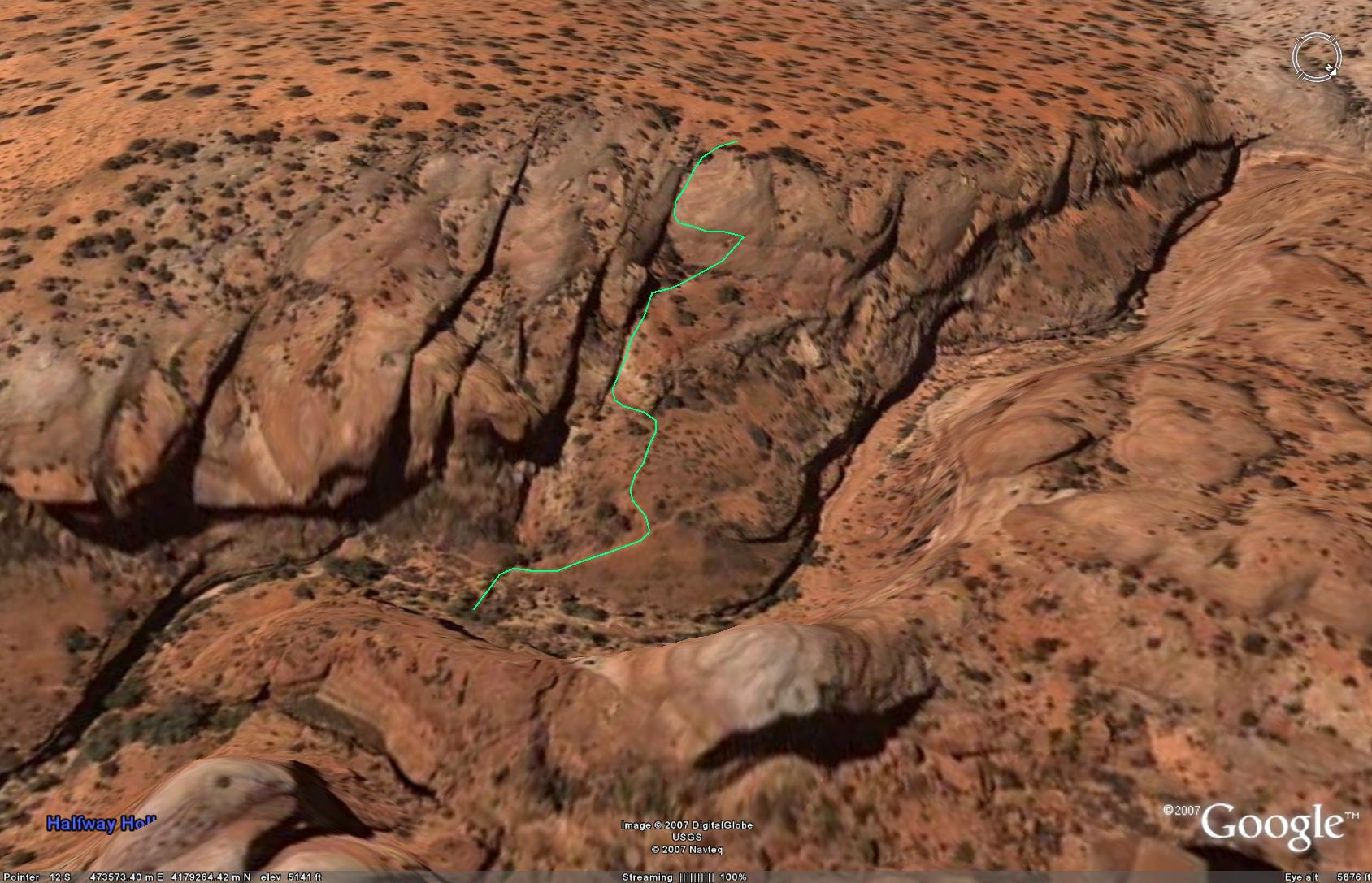
 OK, once on top, it was time to find the spot to get down. When you get up on top, you are likely to encounter paths, cairns, etc, where people have walked, that may or may not be useful. The route is not well cairned, which is fine, since it add to the sense of adventure. Basically, what you do is to stay high until it is time to descend, essentially in one long line, all the way to the canyon floor. To do this, you head about 500 meters due west from the point where you got to the sand, obviously following the easiest line, and then turn to the north and go about 300 - 400 meters north. Then you want to descend, just slightly south of east, to the following point, which is approximately the location of the final down climb: 12S, 473218 E, 4179312 N. Of course, if you are not into GPS, or waypoints, or map reading, there is another approach. When Susie and I had looked at photos from the 1986 trip, I had noticed a distinctive dark stain on the far wall of the canyon, and Susie had noticed an opening in the rock which she immediately nicknamed "the Asshole." Why? Well, because that is what it looks like: an anal sphincter. And frankly, it is a heck of a lot easier when you are hiking up and down over these big pillows of slickrock near the canyon rim to have something visual to be looking for, rather than a spot on the map, because frankly, you can not see the floor of the canyon until you are very close to it. So we hiked in the general direction that the cairns were taking us, until we spotted the afore mentioned formations on the opposite canyon wall. Immediately, the troops were smiling, because there was something concrete to head toward. Here is a link to a photo showing the descent route with the "Asshole" and the brown stain.
 And thus, we began the 300 foot descent. Basically, straight toward the formations, and then, when you get close to the bottom, a jog to the right to about the only point you can get down for a very long way (there is a route down, which Ray found and which some guides mention, about a mile upstream from the "official" downclimb. We got to the point where it was time to take off the packs and shimmy down the last stretch. 21 years ago, there was a large log that someone had placed up against the canyon wall to facilitate. The same log is still there. The difference is that in 1986, many of us walked down the slickrock with our packs on, with the assistance of Lance, standing on the top of the log to guide foot placement. This year, we all took our packs off, used a static climbing rope to lower them over the side, and most of us were belayed on the final part of the descent. (Ray didn't trust the security of the belay,he told me later, so opted out.) I helped Will, the best rock climber of the group, do the belays, until it was time for me to drop down. I went down with a rope around me, but really did not use it, and Will descended un-belayed. (I think going up this route, headed downstream, might be a bit easier than going down it, like we did.). I guess we are getting more conservative as we get older. Boy, now THERE is a surprise.
 We walked back down to the point where the water drops over the falls into the narrows, and I commented again how it just seemed to me that the drop was much less than it was 21 years ago. I made a note to check this out when I got home. We spent little time look at the narrows from above, because it was getting late. By the time Susie and I picked up our packs and started to move up canyon, it was 4 pm. Ron had decided to forego examining the narrows from the top and was heading up canyon, so he had been our designated campsite finder. Based on studying Google Earth, it seemed that there would be a decent spot to camp about a half mile upstream from where we had hit the canyon floor. So I knew we did not have too far to go.
 Well ....... We hauled ass up the canyon for about 45 minutes (when you see how little distance we had come, one has to conclude that there was little real "ass hauling"). At this point, we had decided to heck with my planned campsite. The first available campsite would be the one we would take. As it turned out, where I had planned to camp was a non-starter, but about 500 meters upstream, there was a lovely little spot (12S, 472714 E, 4180526 N). It was tight up against the west wall of the canyon, which meant it had nice afternoon shade and a bit of grass. There was water flowing in the stream bed, and it was big enough to accommodate all our tents on reasonably flat surfaces. Heaven on earth, for sure. I even noted that at the north end of the bench, there were a couple of Ponderosa Pines growing, which I took as pretty interesting, give that we were below an elevation of 5200 feet. We had pulled into camp at 4:50 pm, or just exactly 8 hours under pack. Fairly full day, even though during the pack hauling, we had a break from hiking.
Susie and I got some water, headed upstream for a discrete and environmentally friendly bath, and started dinner as soon as possible. We sat around chatting for a while after dinner, but it seemed like everyone had had a tiring day. Time to hit the sack.
To view supplemental photos of this trip, go to our TwoHikers PicasaWeb gallery.
© Roger A. Jenkins, Suzanne A. McDonald, 2007