
Wolverine Creek to the Upper Gulch
Saying Goodbye to the Escalante
A Dose of Reality
Monday, April 30
 The night cooled off, eventually, and it felt good to sleep and get up when we needed to. We figured we had a fairly easy day ahead of us, since Susie and I had both decided to pass on going up Little Death Hollow. We had been up it a fair piece in 1999 and I had been up LDH in 1986. So we decided to opt for the lazy approach. Little did we know.
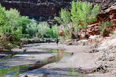
We could tell the day was going to be warm, as soon as the sun hit our tent area in camp. We were outta camp at 9:15 am, and took a leisurely stroll down Horse Canyon, photographing our friends in the distance. Susie was even able to pick out the slot that George and I had gone up in 1986 to get on top of the mesa on canyon right. It was clear that with the exception of Ray, everyone else was headed up LDH. (Andy would even admit later that it took him a long time to recall that he and Sue had been up it in 1999. Ah, we are all getting older...) Susie and I arrived at the mouth of Horse Canyon about 11:10 am, and I could tell right away that things felt a bit different. (When I returned home, I went back and examined the photos from 1986, and realize that things were a LOT different.) Susie and decided to pump some water flowing out of Horse, since it would be a while before we got to the lovely spring just downstream of our planned camp below the mouth of The Gulch. (As it turns out, we are very glad we got water when we did.)
 The first thing I noticed was that we had to work at crossing the river where we were. Actually, we went downstream maybe 50 meters to find a shallower spot. What had happened to the riffles and rapids just down stream of the mouth of Horse? We then had to really work to find a way up the steep embankment opposite the mouth of Horse. Oh well, I thought, things change. Brother, do they. As I got to the top of the embankment, I could tell that things were different. Way different. It was like hiking on a beach with sagebrush. It was also pretty clear that most of the big vegetation was pointing downstream. There seemed to have been a recent flood. Ah... That is like saying there is usually a bit of hype surrounding the Super Bowl.
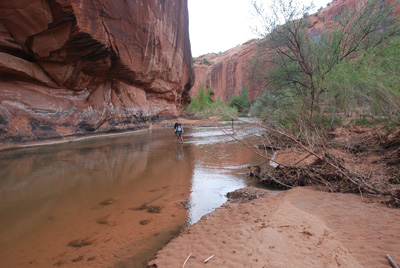
OK, let's back up here: Yes, there was a flood. A once in a lifetime flood. Last October. October 6, 2006, to be exact. Look at the photos on this page. I had seen these photos prior to our trip, but seeing them, and experiencing the changes first hand, is two different things. One can look at Google Earth photos all one wants to, but that was then. This is now. Apparently, the Escalante and many of its tributaries had experienced the Mother of all Floods last October. It rained and rained. And that amount of rain in this country is bound to lead to serious flooding and serious changes. It appears that the Escalante filled in many places from wall to canyon wall. Clearly, this would be a different place than we had experienced on our previous 8 trips into the Escalante system. Grassy benches cut with cow and human tracks? Gone. Many trees? Now blow downs (or "flooddowns"). We got our first taste of what would be in store for us as we approached the end of the first bench. Massive amounts of flood debris that you have to work your way through. And finding the spot to get down to the water was more challenging, since many of the human paths had disappeared. The river banks had changed in many places. Well, it was clear that we would be in for a really fun afternoon.
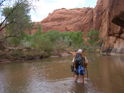
 With Ray right behind us, we worked our way upriver. We stopped for lunch at 12:15, and I took a GPS reading, and then laughed. Why? Because we were moving sooooo slowly. It was simply hard to pick one's way through the debris. (Our friends who were behind us, exploring Little Death Hollow, would comment that had it not been for our tracks, it would have taken them as long as it took us to get up river. At this point, Susie mentioned: "You know, we may need to start thinking of an alternate campsite for tonight, since the one you had planned may be gone." I thought to myself: if it is ALL like this, I am not sure WHERE we might camp.
We plodded along after lunch, picking our way through debris, and working to find places where we could get from the bench down to a suitable crossing of the river (there would be something like 18 crossings or so in the stretch between the mouth of Horse canyon and the mouth of The Gulch), and stopped briefly after about an hour and 10 minutes or so, directly across from a small side canyon opening on the north side of the river (near 474868 E, 4175018 N). We just wanted to confirm where I thought we were (ie, still way downstream of the Mouth of The Gulch), since it just felt so different. My other excuse was that I wanted to munch on a granola bar. By now, it was well after 2 pm. And even though it looked like we only had a couple more canyon bends to go to camp ...... Well, you never can tell.
 Finally, I could see that black stain on the wall (canyon left) that marks the spring right below the camp we had used in 1986. (We had stopped at this spot in 1999 to water up before moving further upstream.) We got to the planned camping spot just a couple of minutes before 3 pm, so it had taken us 3.5 hours to make perhaps 2.5 miles along the river and its benches. In contrast, in 1999, it took us 2 hours 13 minutes to go from our campsite up in Horse Canyon to the spring. Anyway, to say that the planned campsite was a disappointment is an understatement. Frankly, it was in sorry-ass shape. Sure, there were some trees there, but all the grass was gone, and covered with long piles of sand, running perhaps 50 - 100 meters long, parallel to the river course. Yes, it would be possible to camp there, but it certainly was less than ideal. Way less. So Susie and I dropped our packs and headed upriver, through the tangle of brush that marks the upstream end of this bench on canyon right, directly below the mouth of The Gulch. We looked on both sides of the main canyon, and even went up into The Gulch, where Susie reported a possibly better campsite, though much smaller, than the planned site. We headed back to where we had left Ray and our packs, and ran into Ron and John who had arrived and were also looking for campsites across from the planned spot. I went over to check out their suggested spot and thought it was only marginally better. Still piles of sand, that I reported when I got back to the planned spot. At this point, we did run into a couple: a physician from the Czech Republic and his significant other from Slovakia. They indicated that they had been coming to the canyons since 1982, and our group was the most people they had seen in a stretch of canyon in a long time. The woman, who had been noticed down canyon by some of our party earlier, was hiking in sandals and was rather minimally clad (the guys had reported this right away). I thought to myself: boy, with that much skin exposed, she must be a super hiker, since she was not scratched up.
I looked at my watch, and it was pushing 4 pm. Ron showed up about this time, and reported that the spring was no longer flowing from a practical standpoint, another change in the canyon. (In 1986, it had been gushing, and in 1999, it was still flowing well.) So readers wanting to hike in this stretch of canyon: do NOT plan on getting water from the spring that all the guidebooks mention. But the lack of spring water below the camp made our decision easier: we would camp at the spot that Susie had spotted up into The Gulch a ways. At least there was easily treatable drinking water (the river was fairly clear, but always nicer to get your water from a small creek), and flat sand, as opposed to mounded sand.
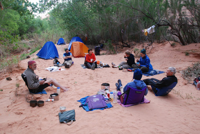 So Ray came up the creek with us, Ron and John stayed down at the planned spot to direct traffic to the new campsite. The spot we eventually stayed at (12S, 473790 E, 4175394 N) was tight, as we were spread out along the obvious path up The Gulch, but there were enough places for everyone. Sue and Andy showed up not long after we arrived, as did Will and Kim. All the chicks were in the nest by 5 pm, which was not too bad, seeing how we had moved further along our route and all but Susie, Ray, and I had chosen to go up into Little Death Hollow at least a ways. Dinner was orzo with chicken, peas, and Asiago cheese, always a good choice, and lots of conversation. Most seemed to center around the damage that the flood had done. One of the most notable features of the campsite was the pulsating water flow in the creek coming down The Gulch. We first noticed this as we were collecting water for dinner. The creek would alter its flow of water on a 20 minute cycle. It would be down, and then up and flowing places it had not flowed when the water flow was lower. The amount of sand and silt in the water would also fluctuate. Since I am not a hydro-geologist, and no one else on the trip was, it was a simple mystery. We have seen water flows fluctuate before in canyon country, but the cycle was vastly slower. Maybe someone who reads this report will come up with a simple explanation.
To view supplemental photos of this trip, go to our TwoHikers PicasaWeb gallery.
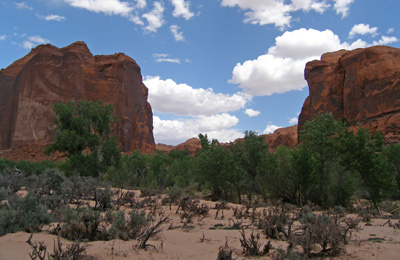
© Roger A. Jenkins, Suzanne A. McDonald, 2007; Photo of sand and sagebrush covered bench © William H. Skelton, 2007