
Grand Gulch 2001
Collins to Todie - Opus 2
Many ruins
Tuesday, April 17
 A cool night: 35 degrees when we got up, just a tad before 7 am. Today, our goal was the mouth of Cow Tank Canyon. I had picked that spot due to the reported presence of a spring. However, after the trip, I read in a hiking guide which I had previously not realized contained a great write up of most of our trip (the Falcon Press book on hiking in the Grand Staircase/Escalante area) that the spring is above a pour-off which seems to be impassable. So don't count on it. Also, on the previous trip, we had done the big slug out from Collins to just below Polly's Island in one day. That is about 10 miles. We had then done short days pretty much for the rest of the trip. It seemed only prudent with our aging group demographics to try to break up the 21 miles between the Mouths of Collins and Bullet Canyons into three days of equal pain. In general, in Grand Gulch above the narrows, the hiking is pretty easy. The main issues to deal with are loose sand (imagine hiking on a beach above the surf zone with a heavy pack, and you get the picture) and the heat. In the 15 miles of canyon downstream of the Narrows to the San Juan River, the Gulch changes character, and the last few miles can be pretty interesting. OK, in a couple of places, it is downright hairy. But we'll save that for another time.
The loose sand you can't do much about: it is always a trade-off: go across the bench to save some distance, but to do it, you have to put up with the sand, and during parts of the day, the sun. And as to the weather, I think April is the best time to hike in canyon country. Sure you have to put up with some occasional cool nights and days, and the potential for light snow, but such beats baking your brains out. The heat can really sap your energy. And while lots of folks think that highs in the 70's is just perfect, they are obviously not hiking in the sun with 60+ pounds on their back. 70's in the shade is 90's in the sun. Give me a high of 60 and puffy white clouds any day!!
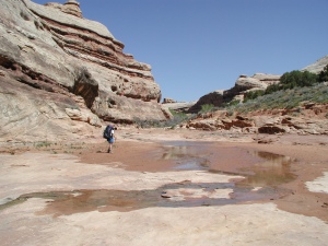
 While we were hopeful that a cool morning would mean a cool day, prudence suggested we haul our butts out of camp and get hiking before the heat of the day caught up to us. Susie and I were underway by 8:50 am, and made the arduous climb past the pour-off in the loose sand. The stream bed was ominously dry, but both of us had a couple of liters of water, so we figured we should be OK for a few hours, especially in the cool of the day. After a few hundred meters, the path takes a short-cut, not going around the canyon wall, but through a break in it. Just after that, we ran into a 30-ish guy who was hiking, in the 6 remaining days of his trip, all the way to the San Juan river, then along the north side of the river, where there supposedly is a path through the blocks of talus to the mouth of Slickhorn, and up and out Slickhorn. We marveled at his fortitude, or ability or what have you. We had attempted a similar trip concept back in ‘85, starting out by coming into Grand Gulch below the Toilet Bowl, but when we got to the San Juan, it was blazing hot, already afternoon, and there seemed to be no way to cover the 5 miles to the mouth of Slickhorn before nightfall, so we turned back. We wished him luck, and appreciated his report that as we headed upstream, the water would start flowing soon, and while we would run into stretches which would be waterless, the springs were flowing well. I was feeling better already.
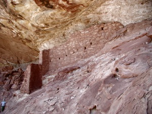
Before long, we were confronted with what could be called the "Turret ruin" and the "triple door ruin." (There are so many ruins that one has to do something to distinguish them.) These ruins, which are pretty inaccessible, are in wonderfully good shape, look like, believe it or not, a small turret, with beautifully rounded walls, and three nicely intact doors, or windows. We stood there photographing them with long lenses for a bit, but decided to push on, hoping to spend some time exploring the ruins below Polly's Island before lunch. In ‘82, we had camped our first night "up river" on a lovely grass bench just downstream of Polly's Island. The latter is a formation that is an arrowhead shaped canyon wall that is part of an ancient abandoned meander. (The coordinates are 578,298 E, 4,144,084 N. Note that on one side of this isolated monolith, there is a panel with seemingly hundreds of hand prints. Certainly worth a look if you have time to make it around the rincon.) Just downstream of the bench, on canyon wall right (578,188 E, 4143,693) is a set of nice ruins, the lower section of which is pretty easy to get to. The upper set requires a bit of a friction walk that Susie did not feel comfortable making; but Ray, young man of 70 that he is, seemed to have no trouble. We spend some time checking out the pottery shards and 1000 year old corn cobs, and then decided it was time to move on. There are simply too many things to see and do.
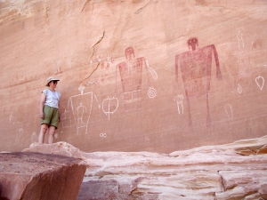 Next stop was the mouth of Polly's canyon, mainly for lunch. Several of us gathered. I pulled out my Chair, but the day was warmer and the shade not as complete. More jerky, pepperoni, and crackers, the usual lunch staples. Susie and I split a liter of water, but I knew that wasn't going to be enough to hold me for a while. She wanted to move on, because we could feel the day warming up, so we pulled out and headed for Big Man Panel. (It seemed like there was a destination every hour or so.) By the time we got to the vicinity of Big Man Panel, it seemed like the air had warmed considerably. Maybe I was just thirsty, but things seemed to have gotten a bit touchier. Since the marker on the Trails Illustrated map had placed the Panel in the middle of the creek bed, which was clearly not the case, I had guessed that it was on canyon left. We met a party that explained, no, it would be on our right, and it was still a ways up canyon. By the time we got to it, all the heat seemed to be under Susie's collar, and I had to work to encourage her to climb the couple of hundred feet up very steeply to the panel. To be sure, the Panel is well worth the energy expended to reach it. There are several large figures painted, one obviously of a pregnant woman, and one of a male. You can determine the gender due to his anatomical correctness. And just so there are no more mistakes (canyon left, canyon right, in the streambed), the exact coordinates are 579064 East, 4145452 Northing. (The reading was taken up at the panel.) We plunged back down through the loose sand, and I reminded Susie that I need to pump some water for drinking, and that seemed to be enough to drive her over the edge. She hoisted her pack and took off hiking solo, muttering something about not needing so much water. I knew it had to be the heat speaking, because this was coming from the mouth of a person who is always extolling the virtues of drinking lots and lots of water.
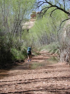
I drank nearly a quart of liquid, and pumped another quart to carry, and headed off. I think everyone was tired of crossing the dry, hot benches of loose sand, so we started walking in the stream bed. In some places, the stream-side vegetation was sufficiently dense to provide a canopy of shade, which helped the environmental conditions, along with the cooler wet sand in the stream bed. Barbara, Ray, and I caught up to Susie in a half mile or so, as she was coming back from exploring a small ruin. She seemed to be in a better mood, so we trudged on in the general vicinity of each other, knowing that it was only another mile to camp. We got to the mouth of Cow Tank Canyon a little after 3:15 pm. Not very good time, but we did look at a lot of ruins.
 Believe me, Cow Tank was nothing to write home about. The mouth itself was a dry sandy bench covered with cacti and brush. Not a spot to pitch a tent. However, just across from the mouth, there was some open spots in among more dead tamarisk ("shades" of last night), but this was not quite as homey. However, there was flowing water in the main stream bed, albeit not much, and it was here. We spend a lot of time trying to make the most of the limited camping spots, and then Susie and I went off to clean off the grunge of the day. By the time we had cleaned up and done a bit of laundry, it was time to think about dinner. We declared the flat spot right in front of George's tent as the community kitchen. He offered little protest, mainly I think because he did not have to move far. Dinner was Cajun Rice and Beans with dried ham, but we were lusting after John's dried Knorr tomato/basil pasta sauce. He did not seem to like it, but it looked pretty good to us. After dinner, we mostly sat around and chatted, as there seemed to be little place to go explore. The canyon is pretty tight here, and movement either upstream or downstream required re-wetting of the feet, which did not seem very appealing. We watched the stars come out and tried to analyze why we all seemed to be dragging this day. We were at the halfway point of the trip, so our packs should have been lighter. Maybe it was the cloudless sky, but maybe we were all - with the exception of Cora - more than a bit older than on the previous trip. It was a good thing to ponder as I crawled into my sleeping bag.
© Roger A. Jenkins, 2001