
Grand Gulch 2001
Collins to Todie - Opus 2
Green grass and more ruins
Wednesday, April 18
 Not anywhere as cool as the previous night, and with our longest (in terms of distance to the next camp) day ahead of us, we were out of camp by 8:45 am. Everyone had been up for a couple of hours, most likely because they had recovered their sleep deficits from the workday lives. Our first stop was the mouth of Dripping Canyon. It is really a big canyon, as are the next several coming in from the north (Step, Green House), but we really did not feel like we had the time to investigate it very far. We did stop and climb up a bit, looking for some pictographs. There was a small panel on the west wall of the canyon. About this time, Andy showed up and read to us from the hiking guide pages he had brought with him, indicating that the stretch from Dripping to bullet canyon was "the most arduous trek of the canyon". Now it is true that there is more vegetation than what exists downstream, but more vegetation makes for more organic matter in the soil, which makes for much easier walking. I will take a few leg scrapes any day if I can get solid footing.
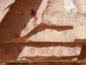
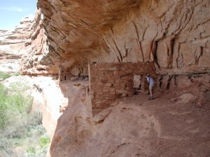 Upstream of Dripping we passed over a nice bench (at 580,828 East, 4146590 North) where the crew had camped in 1982. It was still grassy, with nice cottonwoods. Susie remarked something about why we were not camping at all the great spots we camped at previously. I reminded her that we had to bust our butts to make it further upstream on the first day back in 1982, and it was not clear that the 2001 group would have been as pleased with a long trek. Besides, we were going to be at the mouth of Bullet tonight, which would put us back on the ‘82 schedule. We motored along, pushing the distance to Step canyon, where a neat pictograph panel and major ruins awaited us. There is a small campsite on canyon left, just immediately below the mouth of Step. There is a trail behind a big cottonwood, which leads up on to a bench. If you follow the bench back a couple of hundred meters, you will see the pictograph panel that was in a photo that the Wilderness Society used in the mid-80's to illustrate the cultural resources which were threatened on Cedar Mesa due to a lack of Wilderness designation. The panel is one of many along a wall on the west side of the canyon, but it is distinctive. There is a figure with bent legs which can only remind you of a downhill skier. We explored along the wall, and looked at some pretty run down ruins and more pictographs. As we were walking out of the canyon, you could see some ruins partway up a wall upstream on canyon left. These are pretty neat, and one is a two story ruin, so we had to investigate. I recall taking a look at these in 1982, and seeing Lance and Carol walking upstream. I recall much less vegetation than now, but without direct photo comparison, I am not sure.

We headed a bit further upstream, but hunger was getting the best of me. We found a cool shady spot down by the creek, and sat down for lunch. Ray, Andy, and Barbara passed us, reporting that they had checked out the ruin, but were headed now for Green House Canyon. Susie and I dawdled at lunch, enjoying the cool and the shade and knowing that the warm afternoon lay ahead. It always seems like we slow down after lunch. Maybe it is siesta time, mentally, or maybe it is the blood rushing to the stomach to digest the too-much-food eaten for lunch. Anyway, we finally hoisted at 12:30, and trundled on up the canyon. We decided to bypass Green House Canyon, wanting to push on to camp. About 1:45 pm, we climbed up a very very steep bench, and were amazed to be standing on a lush, grassy bench (583,663 East, 4145,233 Northing). It was several acres in size, and reminded us of someone's lawn. Very strange, but lovely. We took a rest break just upstream from this spot, and could see several ruins on the canyon wall to the northeast.
We pulled into our projected campsite at the Mouth of Bullet Canyon at 2:50 pm. Wow, what a difference 19 years makes. On the first trip, there was absolutely no place to camp anywhere near the mouth. Way too much brush.  We had to head up into Bullet nearly a half mile to find a flat area. Now, all that brush has been beaten back, as the route from Kane Gulch to Bullet and out has become the de facto standard trip in Grand Gulch. The confluence seems to be THE SPOT to camp. Based on the amount of llama pellets around, we think this is a spot used heavily by those folks who still don't want to be their own beasts of burden, but let some animal do all the work. For this, they shell out big bucks and put up with a week of llama poop and someone else's cooking. Well, that's why they make chocolate and vanilla ice cream. Anyway, the camp at the confluence was not too bad, and George and John, who were off looking for better digs when we arrived, reported this was the best spot in the vicinity. Actually, you could set up several parties in this one area. Once we finished picking out just the right spot to pitch our tent (a luxury because usually, there is not that many choices), Susie and I cleaned up near the still-flowing creek, and did a bit of scouting up on the bench high above our camp. I think we were both looking forward to a half day of non-packing after three full days, and 21 miles of carrying. (A note here about the water situation. Today, we had continuously flowing water the entire route. We even had to get our feet wet, finally. We would be expecting the water to stop flowing right above the mouth of Bullet, which it did.) Dinner was chicken and mushrooms with pesto pasta, and the entertainment for the evening was swatting mosquitos. Mind you, this was not Wind-Rivers-In-July bug levels, but the sky had clouded up, keeping a bit warmer than most evenings, and our winged friends were taking the opportunity to feast on human blood. At least they were trying.
© Roger A. Jenkins, 2001