
Grand Gulch 2001
Collins to Todie - Opus 2
Exploring Bullet
Thursday, April 19
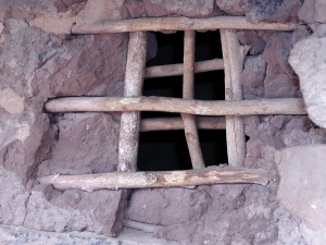 Today was supposed to be semi-relaxing. Only a couple hours of hiking from one camp to the next. And if you believe that, there is a bridge right outside Brooklyn I would be happy to sell you some shares in. Actually, we were up early, a little after 6:30. A quick breakfast, following by packing up most of our gear, and then up Bullet Canyon, headed for Jailhouse Ruin. The first thing I noticed as Susie and I strolled (OK it was not a stroll, we ended up covering the 2.5 miles or so in less than an hour) was that there was a very strong path up the canyon. 19 years ago, no path - you had to walk in the stream bed, and sometimes it was slow going. For those unsure of Jailhouse Ruin's location, it is at 587,392 Easting, 4143689 Northing. Susie and I had run into a party that was hiking up to the ruin, having made a dry camp up in the canyon a ways. Three young guys (defined as anyone less than 40) from Southern California. They were on their way to exploring the famous ruins as well. Why "Jailhouse"? Well, the photo tells it all: part of one wall has eroded away, and you can see the re-enforcing wood bars (that the Anasaz used because, steel rebar had not yet been invented) in part of the structure. There are several petroglyphs, and more ruins at this site. I tried to get a GPS fix, as the ever patient Susie put up with more wasting time, but I sensed that the time required to gain all the satellites needed was suggestive of an inaccurate reading. (When I got to camp later that night, I could see that the fix was nearly 500 meters "off," indicative of a bouncing signal?)
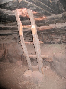
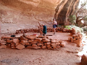 From that point, John, who had caught up with us, Susie and I traversed around the next alcove to the east (it requires a bit of a friction walk in one spot) to get to so called "Perfect Kiva." Actually, there are a lot of "Perfect Kivas" in Grand Gulch. This one has been restored, and it is possible to climb down the ladder into it. I did so, but must admit I was thinking "Hanta virus" the entire time I was in the hole. It is a lovely setting, and it is possible to imagine water being present in the stream bed a thousand years ago, which would have helped with the farming in the canyon bottom. We had seen a sheen on the rock surface across the canyon alcove as we had walked around the wall, and I thought it might be a spring. We traversed around to the east, and were rewarded by a wonderful, albeit small, trickle of water. It was gratifying to find, at least a hundred feet above the canyon floor. As you follow the spring down, the flow intensifies, and one can collect the liquid gold pretty quickly. The spring is at 587,813 E 4,143,482 N.
It was time to make some decisions. We had promised ourselves that we would try to get up to a spot that Will had identified 19 years previously, where 2 relatively untouched kivas were perched high on the canyon wall, in a spot amounting to a few canyon bends to the east. We had also promised ourselves that we would be back in camp, saddled up and ready to walk at 1:30 pm. Decisions, decisions. We opted for the conservative approach, since we were more than 2 miles from camp, and did have a bit of real hiking and sight-seeing left to do. John decided to move on when Susie and I stopped to work on photographing a particularly interesting scene. It had been neat having the former Chair of the Univ. Tenn. History Dept, whose specialty is American Indian history, along on this, perhaps the most "history-oriented" of all the week-long backpacks in the area. John was always good for a bit of commentary, which "fleshed-out" what we were seeing. In a few minutes, we had another example of the smallness and interconnectedness of our world. We ran into a couple backpacking up Bullet. After some small talk, they indicated they were from Arcata, CA. I said, hey, we know the former supervisor of the Six Rivers National Forest. Laura said: "You mean Martha??!!" We indicated positively, and she said she had worked for Martha in the Forest Service Office. We said, well, we were skiing with Martha a couple of months ago at Beaver Creek in Colorado. (At the time Martha was the Supervisor of the White River National Forest .) Another example of why you have to always be on your best behavior.
We were back in camp, after a nice lunch in the shade of a large pour-off in Bullet about which I had completely forgotten, by 1:15. We packed up the remainder of our gear, chatted a bit with some of the folks that were passing through (it seemed like a city sidewalk because we had seen over 10 people already today). We knew we did not have too long to go before the water ran out in the creek bed, so we loaded up with more than a liter each, and pulled out just at 1:30 pm. Indeed, the water disappeared from the creek bed about a kilometer upstream of the mouth of Bullet, and it was comforting to know that we had enough to get all the way to the next camp, let along the next spring. The latter, in fact, was our next "scenic turnout." Shieks Canyon comes in from the east, about 45 minutes up from the mouth of Bullet. We pulled up, and dropped our packs in the shade of some brush. 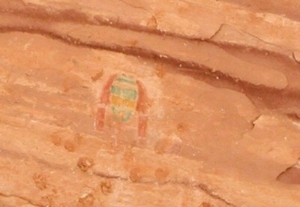 There was a small campsite with two tents filling all the available space right at the mouth. A little less than a half mile walk brings you to Green Mask Spring. When you get up canyon to where the water starts flowing, just look up to the left, and you can see one of the best panels of pictographs around. The piece de resistance is the Green Mask itself, the only one on Cedar Mesa, I have read. You can even see where the Anasazi kids used it as target practice for their mud balls. What is really amazing is that the mud has clung to the canyon walls for nearly a thousand years. We lingered a while, and took plenty of photos, but soon, it was time to move on. So we trooped back down Shieks, and hoisted. Since walking without a heavy backpack feels like you are floating, we declared that we did not need a rest stop here. However, had someone else needed one, I would have been happy to keep them company.
Another 45 minutes of dry stream bed hiking brought us to the mouth of Coyote Canyon, our stop for the night. George had already set his tent up across the Gulch, and was waiting for the rest of us. Knowing what was on my mind, he immediately reassured me that there was great water flowing out of a spring up the side canyon about 300 meters. He remarked that it was breezy up there. After Susie and I decided on a tent site, we packed up our bathing paraphernalia and water bag and headed for the spring. To say it was "breezy" at the spring is like saying that it is windy during a hurricane. Wow. The temperature had dropped into the high 60's, and as soon as you wet a part of your body, it felt like ice. Bathing that evening was perfunctory, to say the least. The rest of the crew was dragging in as Susie and I finished up. I always marvel at the refreshing independence that everyone exhibits on these trips. About the only thing that is "set" is the location of the next night's camp. George and John were usually first into camp. Susie and I will drag in a half hour later, Andy a bit later, but then he has always hiked more side canyons than us. Lance and Cora were always off doing something, and Barbara and Ray seemed to want to check out every ruin. Typically, we would all cook dinner together, and discuss the day's activities, but there is never any pressure to do anything or be anyplace at a particular time. I guess it works well, since some of us have been hiking together for more than 20 years. Since it was not windy at all in the main canyon, we relaxed over dinner, enjoying our version of Santa Fe Chicken and Rice. It is easy, very tasty, and makes a lot. How can you beat that?
© Roger A. Jenkins, 2001