Sierra High Route - 1998
Across Humphrey's Basin
Monday, August 31 (Map) We awoke to some very strange lighting: the sun in the east was being filtered through some smoke: It looked as though a lightening strike had started a fire in the valley from which we had just come. We couldn't determine the size of the fire, but we were glad we were moving in the opposite direction.
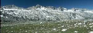
Ok, enough with the foolin' around: it's showtime. Time to cross Humphrey's Basin. Our goal was to cross the entire basin, and make it to Elba Lake. I knew we had a full day ahead of us, and I think most of us we psyched to get going. The northern part of Humphrey's Basin is a huge plateau of rolling sub-alpine terrain, dotted by lakes, but dominated by Desolation Lake. The plateau is wedged between French Canyon on the north, and the Piute Creek Valley on the south. It looks like it should be a piece of cake to cross, because it is - for the Sierras, a relatively flat piece of ground. "Relatively" was the operative word on my mind as we rolled out of camp at 9:10 am. Our objective was to follow Steve Roper's Sierra High route, which had been the inspiration for this trip: why go up and down through the trees in the valleys, if you can stay in the high country. We headed cross country, mostly north from Muriel Lake, with the following crew deciding to stay as high up in the drainage of Piute Creek as practical, skirting the outlet of Summit Lake. Some of the others had taken a lower, somewhat more direct route, necessitating that they climb back uphill to rejoin the Piute Pass trail, heading NW.
 It did not take long to get to the use path that heads NW across the Basin, where the main trail turns west. We gained just a tad of elevation, me dragging my butt up the rear, except for the perennial "slow-pokes" Will and Barbara. I vacillate between annoyance and admiration at their pace. Sometimes I wished they hiked faster, but I also admire their ability to not be pushed (like me sometimes) into moving faster than feels comfortable. And Will's photography has been a lot better than mine lately. They always get to where we are going, so I often scratch my head at why we "rush." But I think the fact that we often get strung out over big distances just stems from the vast differences in
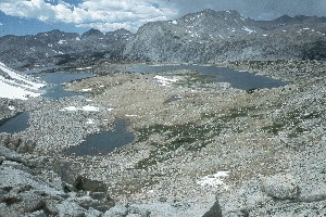
ability, conditioning, load, and style. Anyway, we held up for them at a small rise overlooking Lower Desolation Lake, with me enjoying the opportunity to "commune" with nature. While there was some mild speculation that we might be over near Tomahawk Lake, Andy's GPS confirmed what the more certain of us knew - that we were just below Lower Desolation.
It did not take long to get to the use path that heads NW across the Basin, where the main trail turns west. We gained just a tad of elevation, me dragging my butt up the rear, except for the perennial "slow-pokes" Will and Barbara. I vacillate between annoyance and admiration at their pace. Sometimes I wished they hiked faster, but I also admire their ability to not be pushed (like me sometimes) into moving faster than feels comfortable. And Will's photography has been a lot better than mine lately. They always get to where we are going, so I often scratch my head at why we "rush." But I think the fact that we often get strung out over big distances just stems from the vast differences in
ability, conditioning, load, and style. Anyway, we held up for them at a small rise overlooking Lower Desolation Lake, with me enjoying the opportunity to "commune" with nature. While there was some mild speculation that we might be over near Tomahawk Lake, Andy's GPS confirmed what the more certain of us knew - that we were just below Lower Desolation.
We skirted the lower part of that Lake, crossed a small rise which runs SW from Desolation Lake, and started to drop very gently to Mesa Lake, crossing huge grassy meadows. I could tell that Susie was getting aggravated with me, 'cause I was not "keeping up." Even the short uphills were enough to slow me down, and it was clear that I had not yet acclimated to the altitude. I got fed up with being pushed, ("being pushed" really meaning that everyone else was just more comfortable with a slightly faster pace) so I just stopped for a break at NE corner of the lake for about 10 minutes. It felt great to relax a bit in the sunshine and cool breeze.
I circled the north side of Mesa Lake, and headed up a draw running NE/SW at the NW corner of the Lake. I could see Susie moving up at the head of the draw, but the others (except W&B) had already made the turn to the left. The draw was moderately steep, so that made it slow going for me. Every step was a big one. Right at the spot where I was to leave the draw, and climb more steeply to the left for a bit, Susie was waiting for me, with both barrels loaded. I endured a er, ah..... spirited lecture about being too heavy and out of shape and not being considerate of her, because she was having to hike by herself, etc, etc. I am sure that a few other faults of mine were elaborated upon, but I just endured. I continued to climb past her, up to a spot where folks were checking their position with the GPS. Much to my surprise, there seemed to be some discussion as to our exact location. I knew we still had some climbing to get to Carol Col (also known as Puppet Pass), but other folks thought we were already there. I guess my certainty was due to my having studied the maps so much. By the time I had completely caught up, the rest of the crew had come to the realization that yes, there was still more climbing to do. So I kept on rolling.
 The last 150 meters to Carol Col traverses a flat, covered with snow. Just as we arrived at the Col, it was clear that a storm was brewing up. Even tho it was pushing 1 o'clock, no one wanted to hang around and ponder the view. The view down through the rock and talus was awesome enough. We looked and looked to find a shallower start to the descent, but none could be found, so we just started on extremely steep scree to get into the big car-size blocks of talus. (We had wanted to wait for Will and Barbara M, but knew they were a half hour behind us, and from a safety standpoint, we felt that with the storm brewing, we needed to begin the descent. A large "Crack!!" of lightening reinforced our decision.) Sue was in the lead, followed by Tim and Diane, Andy, Susie, and me. Ray and Mark, and
Dolph and Barb A were not too far behind. (Note how I had moved up through the pack. It must have been all that positive encouragement from Susie.) Carol Col was not horrible, just annoying, because all the talus seemed to be really sharp, and hopping from block to block - there is no real path - required a high degree of attention.
The last 150 meters to Carol Col traverses a flat, covered with snow. Just as we arrived at the Col, it was clear that a storm was brewing up. Even tho it was pushing 1 o'clock, no one wanted to hang around and ponder the view. The view down through the rock and talus was awesome enough. We looked and looked to find a shallower start to the descent, but none could be found, so we just started on extremely steep scree to get into the big car-size blocks of talus. (We had wanted to wait for Will and Barbara M, but knew they were a half hour behind us, and from a safety standpoint, we felt that with the storm brewing, we needed to begin the descent. A large "Crack!!" of lightening reinforced our decision.) Sue was in the lead, followed by Tim and Diane, Andy, Susie, and me. Ray and Mark, and
Dolph and Barb A were not too far behind. (Note how I had moved up through the pack. It must have been all that positive encouragement from Susie.) Carol Col was not horrible, just annoying, because all the talus seemed to be really sharp, and hopping from block to block - there is no real path - required a high degree of attention. 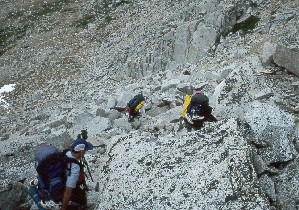 But the going was slow. Mountain goat Sue continued to pull away. I pretty much stayed up right behind Susie, who was right behind Andy. It took us about 45 minutes to descend the 300 feet or so to a place where we could all gather and rest. It was a late lunch in the sun (the storm had passed over with just a few drops), while we waited for the remaining 5 folks. When we could see that W&B were safely starting the descent, Susie and I volunteered to take off for Puppet Lake, hoping to find a pretty good campsite for the crew. Our original goal had been Elba Lake, but it was clear that we were all tired of having so much fun, and a little extra added to tomorrow did not seem like a big deal. We descended, and skirted around the south side of the lake. On the north side we settled for some sites, but the wind was picking up, and it was clear that some storm clouds were building. (Note at this point that ass-dragging Roger has moved up to number 2 in the pack.) It wasn't too long before the others started showing up, and we all started to set up camp. The sites were exposed, but they were the best at the Lake. There weren't really any particularly good spots to bathe, so Susie and I rock hopped out to a point where we could at least get to some water. In less than 5 minutes, the rain started, and Susie got mad and ran back to the tent. I stayed to finish my bath, thereby sealing my doom: When I had left the tent area, I/we had left a lot of our gear exposed to the elements. I had forgotten this, but not Susie. As she was the one in camp, she was the one who was stuck with trying to get as much of the gear under dry cover, while yours truly blithely bathed to his hearts content. (OK, so maybe blithely ain't the right word here - it is hard to be blithe when the wind is roaring, the rain is picking up, and you are standing there stark naked to the elements, trying to scrub the day's grime off.) So when I got back to camp, I was in deep doo-doo.
Fortunately, the sun came out, although the wind did not die down, so I decided that we should huddle behind a big rock near Andy, Sue, Diane, and Tim. The company seemed to do Susie's mood some much needed good. It is always amazing to me how some folks can get in such bad moods so quickly, even if they have a good reason for it. I seem to have been blessed with a good disposition, so I can never understand why everyone can't view the world just like I do. Anyway, the rest of the crew had hiked up on to the ridge above the campsite, about 150 meters away, and were sheltered by some trees. Sorta. Meantime, Sue had done some scouting around, and found that the High Route way was another heavy duty talus slope, off this shelf that Puppet Lake was on, down to the vicinity of Moon Lake, off to the NE. However, if we cut about 300 meters to the west, there was a little drainage that we could drop down through, with only a minor amount of snow to cross, and no talus, just nice grass. So that was our plan for the next day.
© Roger A. Jenkins, 1998