Sierra High Route - 1998
Over Feather Pass
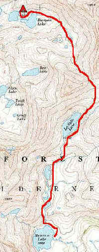
Wednesday, September 2 (Map)
 Today would be a big day for us: The High Route guides one across Feather Pass, a couple of miles (and ca. 1400 feet) above Merriam Lake. Given the heavy snow pack dropped by El Nino, we thought it a pretty high probability that we would cross some snow fields on the way to the pass. We were right. Susie and I were the last folks out of camp, the northern contingent having a 150 meter head start on us. Our first job was to get around the NE corner of the lake, and head up the west side of the cascade. One can go up the east side, but it would be even more scrambling. The west side is a series of grass covered steps and boulders that one can switchback thru for 250 feet or so of climbing. We leveled out at a series of lovely tarns, connected by a steam, and could see the rest of the group a quarter mile ahead. We stayed on the right side of the drainage (after skirting the first lake on the west side), and walked nearly level for about a kilometer. As we got to the next pitch (these things are never gradual - when you go XC, you have to be both mentally and physically prepared for flat followed by steep, followed by flat, etc. Nothin' is easy.) we caught up to some of the crew, altho I needed a bit of a break. I still did not have my wind, and we were halfway through the trip. From this point, it was another steep climb on granite slabs up to LaSalle Lake. Actually, one climbs above the lake and does a traversing descent to the inlet. The snow field was not too sloped, so I did not have much fear of slipping
down into the Lake. Somehow, by this time, Susie and I had moved up through the pack again, and there were just a few footprints in the soft snow.
Today would be a big day for us: The High Route guides one across Feather Pass, a couple of miles (and ca. 1400 feet) above Merriam Lake. Given the heavy snow pack dropped by El Nino, we thought it a pretty high probability that we would cross some snow fields on the way to the pass. We were right. Susie and I were the last folks out of camp, the northern contingent having a 150 meter head start on us. Our first job was to get around the NE corner of the lake, and head up the west side of the cascade. One can go up the east side, but it would be even more scrambling. The west side is a series of grass covered steps and boulders that one can switchback thru for 250 feet or so of climbing. We leveled out at a series of lovely tarns, connected by a steam, and could see the rest of the group a quarter mile ahead. We stayed on the right side of the drainage (after skirting the first lake on the west side), and walked nearly level for about a kilometer. As we got to the next pitch (these things are never gradual - when you go XC, you have to be both mentally and physically prepared for flat followed by steep, followed by flat, etc. Nothin' is easy.) we caught up to some of the crew, altho I needed a bit of a break. I still did not have my wind, and we were halfway through the trip. From this point, it was another steep climb on granite slabs up to LaSalle Lake. Actually, one climbs above the lake and does a traversing descent to the inlet. The snow field was not too sloped, so I did not have much fear of slipping
down into the Lake. Somehow, by this time, Susie and I had moved up through the pack again, and there were just a few footprints in the soft snow.
 The snow field runs pretty much the entire right side of the lake, and it took a while to cross. We got down to some grass, and relaxed a bit with our packs on. When you stand on the snow field, and look up the lake, it is hard to see the route, because it is obscured. However, by the time you get to the inlet stream, you can see the break in what otherwise is pretty heavy duty wall, and you head up a slot to the NE. The slot becomes a chute, and there are some pretty big steps, but no exposure. We got to a flat spot a few hundred meters from the inlet and rested (a recurring theme on these cross country days). From this point, we could see that it was only 400 feet of climbing to the NW to 12,400' Feather Pass. Susie rested with me, but as soon as we started back up, she would quickly put 50 meters between me and her. My wind just was not there.
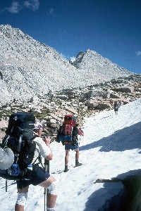
T,D, A, S had gotten to the pass with plenty of umph to spare, and during a scouting sojourn, determined that a lunch stop about 50 feet below the pass was the thing to do. Naturally, I agreed, since it was also out of the wind. Susie and I plopped ourselves in this contorted posture, with our legs up in the air, a pose more fitting for a gynecological exam than a lunch break. But it was warm, sunny and out of the wind, and who knows what lay on the other side of the pass, although a good guess would have been huge blocks of talus. Of course, such would have been a good guess, were it not for the 20 feet of snow that covered all the talus. Boy, were we pleasantly surprised! 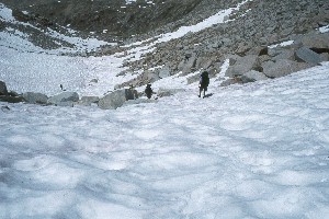 The north side of Feather Pass was, for us, even in early September, a wonderful big snowfield, after you got down through maybe 150 vertical feet of talus and dirt. We say wonderful, because careful traversing of snow zigzagging and switchbacking on down, beat talus hopping any day of the week. It looked like if we were cleaver, we could do a major fraction of the descent without having to rock hop. One did have to be careful where one put one's feet, for the potential for postholing (where you break through the snowpack and end up sunk in to your crotch) was substantial. As usual, TDAS were way out ahead, but I looked at it as letting them find the soft spots. By the time we were 400 feet below the pass (boy, it felt good to be going downhill), we were alternating rock slabs and snowpack every 30 - 50 meters. We stopped above the last pitch above Bearpaw Lake, to drink in the view. You could see way out to the west, and the mountains seemed to go on forever. (Will did break through the snow, and twisted his knee a bit, and he was remarking how sore it was that night.) T,D,A,S were the first to Bearpaw, and they dropped their packs. No one wanted to commit themselves to going further, without insuring that our destination - Ursa Lake - had better campsites than Bearpaw. (Bearpaw's
were OK. That is, there was water and a flat place to camp, but much of the camping would be on sand.) Ray got down next, and we could see him take off, while the rest of us just sort of relaxed and looked at fish in the creek in this small meadow. Ray came back before too long, and reported that there was a nice campsite on the NE corner of Ursa Lake, albeit difficult to keep 100 feet from the water. This was a problem at many of the sites we had: strictly following the regulations of 100 feet from the water would have put us on steep granite slabs much of the nights. But we did stay back as far as we could, and given the impact we have seen from other hikers (mainly TP and fecal matter) we figured we were doing a pretty good job of keeping our impact low. We pulled into camp at 3:30 pm, meaning it had taken us 6.5 hours (inlcuding rest breaks) to go what we think is 3.5 miles. The hiking was not horribly difficult, but it did take time, because it is difficult to maintain a rhythm on the steep granite slabs.
The north side of Feather Pass was, for us, even in early September, a wonderful big snowfield, after you got down through maybe 150 vertical feet of talus and dirt. We say wonderful, because careful traversing of snow zigzagging and switchbacking on down, beat talus hopping any day of the week. It looked like if we were cleaver, we could do a major fraction of the descent without having to rock hop. One did have to be careful where one put one's feet, for the potential for postholing (where you break through the snowpack and end up sunk in to your crotch) was substantial. As usual, TDAS were way out ahead, but I looked at it as letting them find the soft spots. By the time we were 400 feet below the pass (boy, it felt good to be going downhill), we were alternating rock slabs and snowpack every 30 - 50 meters. We stopped above the last pitch above Bearpaw Lake, to drink in the view. You could see way out to the west, and the mountains seemed to go on forever. (Will did break through the snow, and twisted his knee a bit, and he was remarking how sore it was that night.) T,D,A,S were the first to Bearpaw, and they dropped their packs. No one wanted to commit themselves to going further, without insuring that our destination - Ursa Lake - had better campsites than Bearpaw. (Bearpaw's
were OK. That is, there was water and a flat place to camp, but much of the camping would be on sand.) Ray got down next, and we could see him take off, while the rest of us just sort of relaxed and looked at fish in the creek in this small meadow. Ray came back before too long, and reported that there was a nice campsite on the NE corner of Ursa Lake, albeit difficult to keep 100 feet from the water. This was a problem at many of the sites we had: strictly following the regulations of 100 feet from the water would have put us on steep granite slabs much of the nights. But we did stay back as far as we could, and given the impact we have seen from other hikers (mainly TP and fecal matter) we figured we were doing a pretty good job of keeping our impact low. We pulled into camp at 3:30 pm, meaning it had taken us 6.5 hours (inlcuding rest breaks) to go what we think is 3.5 miles. The hiking was not horribly difficult, but it did take time, because it is difficult to maintain a rhythm on the steep granite slabs.
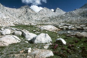
Ursa Lake was a nice spot, although the camping is limited to this little spot on the NE corner. It is a fine grassy spot, but because of the concave shape, there is little nearby bathroom privacy (always a consideration for yours truly). Actually, it was a good 250 meters to the facilities (which consist of scattered dirt and boulders, but a scenic walk never hurts. Anyway, there was a good view to the W and SW, and the view of Seven Gables Peak was magnificant. Frankly, I enjoyed being in a nice tight spot, if only because it forced the group to be together for a little bit at meal time. Of course, being together increased the share of abuse that I received on account of our new stove, the MSR
Dragonfly. It is very noisy, and makes it quite difficult to hear conversation over the roar. Dolph referred to me as a welder on a "busman's holiday." That was one of the kinder comments. Of course, all this stuff was mentally cataloged, so I could write a review of the stove for the Sierra Club newsletter when I get back.
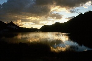
Clouds brewed up while we ate dinner, and as I went back to poke around the lake, the sun dropped underneath the cloud deck to the west, and lit up the face of Feather Peak with a wonderful yellow glow. This was particularly breathtaking against the backdrop of the nearly-black sky, and I yelled that everyone should come up and take a look back to the east. Then I went down and photographed the deserted dinner ring: lots of cooking gear, and chairs, and no people. Kinda interesting. And wonder of wonders, we were actually in the location where we were supposed to be. The first time in a while...
© Roger A. Jenkins, 1998