Sierra High Route - 1998
Down and up to Merriam Lake
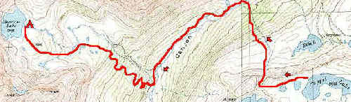
Tuesday, September 1 (Map)
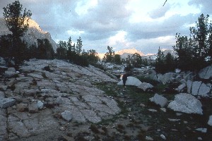
 Lordy, it was windy and wild last night. I congratulated Susie on pushing me to take the LookOut tent, rather than the Clip 3. Andy and Sue, in a Clip 3, reported that they had a pretty rough nite, and so did several others. When we had looked things over, we all agreed that we should have spent the night at Alsace Lake, just a few hundred feet below us in elevation, and maybe 3/4 mile to the west. It had more scattered trees, better camping, and in last night's case, shelter from the wind. After breakfast, the breeze started to pick back up again, and taking the tent down became a bit of a chore. We left about 8:50 am, and all headed WNW from camp, and dropped down the aforementioned drainage. I don't think we had more than 30 meters of snow to cross. We all scattered out (like the proverbial Herd
of Cats) once we dropped down to the shelf on which Elba Lake (our original destination for last night) sits. But the general route follows open steep meadows and the drainage that is probably a half mile or more to the west of where the route out of Elba Lake shows on the topo map. As we got nearer and nearer to the valley floor, the level of winged bloodsuckers definitely increased. We got down to the trail just about a hundred meters upstream of where the creek from the falls flows into the valley stream, and we all put on plenty of bug repellant. Oh Joy. I hate that stuff, mainly because I don't like adding to all the grime and sweat that is already on me. After a nice long opportunity to swat mosquitos, we all hoisted and headed on down the French Canyon trail, looking for the use path that heads up into
Merriam Lake.
Lordy, it was windy and wild last night. I congratulated Susie on pushing me to take the LookOut tent, rather than the Clip 3. Andy and Sue, in a Clip 3, reported that they had a pretty rough nite, and so did several others. When we had looked things over, we all agreed that we should have spent the night at Alsace Lake, just a few hundred feet below us in elevation, and maybe 3/4 mile to the west. It had more scattered trees, better camping, and in last night's case, shelter from the wind. After breakfast, the breeze started to pick back up again, and taking the tent down became a bit of a chore. We left about 8:50 am, and all headed WNW from camp, and dropped down the aforementioned drainage. I don't think we had more than 30 meters of snow to cross. We all scattered out (like the proverbial Herd
of Cats) once we dropped down to the shelf on which Elba Lake (our original destination for last night) sits. But the general route follows open steep meadows and the drainage that is probably a half mile or more to the west of where the route out of Elba Lake shows on the topo map. As we got nearer and nearer to the valley floor, the level of winged bloodsuckers definitely increased. We got down to the trail just about a hundred meters upstream of where the creek from the falls flows into the valley stream, and we all put on plenty of bug repellant. Oh Joy. I hate that stuff, mainly because I don't like adding to all the grime and sweat that is already on me. After a nice long opportunity to swat mosquitos, we all hoisted and headed on down the French Canyon trail, looking for the use path that heads up into
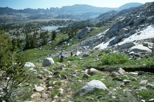
Merriam Lake. 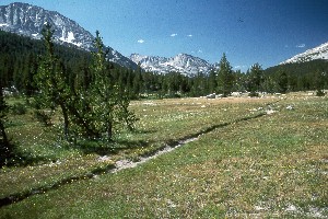 We crossed the outlet stream from Merriam Lake, but, contrary to the High Route description, we did not encounter any strong path. However, not to far past the outlet stream, (within 50 meters or so) we hit the use trail. It was a good, strong path, and there were some switchbacks on it, to take the sting out of the climb, but there was still plenty of sting left. It was slow, steep going.
After about 650 feet of climbing, the route levels out, and we found ourselves in the prettiest place of the trip: a beautiful meadow, with some elevated ground on the south side, great for camping. We ran into several folks up there, who seemed to be base camping. One person said he had brought his wife and they were spending a week in that spot. (The implication seemed to be that this meadow was theirs and we better not plan to camp here.) Susie and I took a lunch break, and it was just a wonderful place to stop: a little too cool to be in the shade, and no sign of a rain cloud. We still had some climbing to do, to get to our altered destination. (Don't we ever stop where we are supposed to? What was happening to our itinerary? The fact of the matter is that you can do a lot of work at home trying to refine an itinerary, but weather, physical ability, etc. can all play a role in altering the best laid plans. Actually, by the time we got to Puppet Lake, we had all agreed that we would not push further than Merriam today, just to make things a little more manageable.) About 300 feet or so, but we knew the terrain would be gentle, so we were not pushing.
Actually, when we headed up to Merriam Lake, we ended up climbing higher than we had intended, crossing a knoll to the SE of the Lake. From the vantage point of the meadow, this had looked easier than going up the drainage. It just meant climbing an extra 60 - 80 feet or so. Merriam Lake was idyllic. It had some very nice sites on the NE corner, and that is where T,D,A,S, S and I stayed. The rest of the crew opted for a beautiful grassy spot, with a real sandy beach just NW of us, by 200 meters. As usual, the group was spread out. It is a good thing that as the "leader," I don't insist of everyone being together. I learned long ago that folks are on vacation, and they will do what they want, so why cause a fuss. Actually, this group was big enough that splitting up when we camped probably acted to reduce the overall impact we were having on the places we stayed.
 It was a glorious afternoon at Merriam Lake. The scenery was the best of the trip so far: you can see all the way back to Carol Col, there is a big granite escarpment across the lake from the camp, a nice cascade pouring down into the inlet, and lots of places to wander. And there seemed to be lots of time to do it: we had arrived at 1:30 pm, so we could really relax. We had been pushing fairly hard for the trip, and had missed our full layover day at Muriel Lake. Susie and I did our laundry and bathed (without the threat of rain, for a change), Tim fished, Andy photographed, and those
folks with all the stamina, Ray and Barbara Allen, took off to explore up into the watershed above our lake. I think they just wanted to get off away from the whole crew. 12 folks can be a lot sometime, and if you are used to wilderness trips with small parties, it does you some good to get away. Dinner was split into two parties, but the northern contingent come over to our spot to share a small trash fire. We watched some great alpenglow on Mt Humphreys, and the peaks which surrounded our lake. We felt a huge "bang" during the sky show, and joked that it must be an earthquake, since we were so close to Mammoth Lakes. (Subsequent photos - which showed a great deal of camera shake on both Susie and my cameras - taken at the time of the ruckus seemed to confirm this, but also increased the degree of humorous derision from our hiking buddies.) I think we would have stayed around a lot longer, but we felt some sprinkles, and knew it was time to dive into our respective nylon shelters.
It was a glorious afternoon at Merriam Lake. The scenery was the best of the trip so far: you can see all the way back to Carol Col, there is a big granite escarpment across the lake from the camp, a nice cascade pouring down into the inlet, and lots of places to wander. And there seemed to be lots of time to do it: we had arrived at 1:30 pm, so we could really relax. We had been pushing fairly hard for the trip, and had missed our full layover day at Muriel Lake. Susie and I did our laundry and bathed (without the threat of rain, for a change), Tim fished, Andy photographed, and those
folks with all the stamina, Ray and Barbara Allen, took off to explore up into the watershed above our lake. I think they just wanted to get off away from the whole crew. 12 folks can be a lot sometime, and if you are used to wilderness trips with small parties, it does you some good to get away. Dinner was split into two parties, but the northern contingent come over to our spot to share a small trash fire. We watched some great alpenglow on Mt Humphreys, and the peaks which surrounded our lake. We felt a huge "bang" during the sky show, and joked that it must be an earthquake, since we were so close to Mammoth Lakes. (Subsequent photos - which showed a great deal of camera shake on both Susie and my cameras - taken at the time of the ruckus seemed to confirm this, but also increased the degree of humorous derision from our hiking buddies.) I think we would have stayed around a lot longer, but we felt some sprinkles, and knew it was time to dive into our respective nylon shelters.
© Roger A. Jenkins, 1998