South San Juan Wilderness 2003
High, Wild and Windy
Climb to Blue Lake
Saturday, September 13
 We woke early at T&D's, determined to try to get ahead of the re-start of the re-paving operation south of town. It was another glorious Colorado sunrise over the South San Juans immediately to the east. Tim was driving the small shuttle car, while I commandeered one of the two "cargo" vehicles. Since we had heard nothing from the crews coming into ABQ late last night, we figured there was to be no change in plans for meeting them at the Branding Iron Motel in Chama, NM at 9 am. But despite our construction avoidance initiative, we still got stuck in the pork barrel operation just north of Chromo, CO. Thus, a push was necessary to make our pre-arranged meeting time. After crossing the Continental Divide for the umpteenth time again on this young trip, we pulled into Chama ten minutes ahead of schedule, to find our crew figuratively tapping their feet in anticipation of our arrival. It turns out that when Ray noted that Andy and Sue's plane had arrived without all of the expected passengers, he checked with American Airlines, and they provided him with their new schedule. Killing 3.5 MORE hours in the airport was more than Ray's patience could bear, so he and Lance took off for Old Town to enjoy a decent Mexican dinner outside the confines of the airport, before meeting our belated friends and ferrying them to Northern New Mexico.
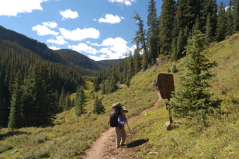
 After the obligatory hugs and handshakes, we went about re-distributing gear to give the folks in the other cargo vehicle a bit more room, and pulled out of Chama and headed for our ending trailhead, the Elk Creek Campground in the Rio Grande National Forest. Besides a few horse trailers, there were a couple of guys who seemed to be permanently camped in a large grassy area where we parked the shuttle car. We half-heartedly apologized about disturbing their space, made one last check to make sure that nothing critical had been left in the shuttle car, and headed off for the notorious drive up the long gravel road past Platoro, and around the reservoir to the Three Forks trailhead. Washboard and pothole city. The road is not as bad as say, the road into McCarthy, AK, as with a mini-van, you can move along at about 30 mph. Sedans, with their lower clearances and poorer visibility, should plan on an hour and 20 minutes to cover the 32 miles. The trailhead was packed with horse trailers, their occupants having long since left to churn up the mud on the wet trails. A breeze was starting to pick up, and a few scattered clouds punctuated the crystal blue sky. Life was good, until I hoisted my 65 pound pack. Susie had agreed to carry our tarp the first day (Andy and Sue were carrying the poles and cover of the other one) to make the climb a bit easier. I am forever in her debt!
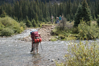
We were underway by 11:11 or so, a few minutes a head of schedule. It was supposedly only 5 miles or so to Blue Lake. But a 1400 foot climb would definitely slow progress. T&D and Susie and I at least had the benefit of having slept the last couple of nights at 7500 feet, but even the relatively flat terrain out across the beautiful meadows caused me to huff and puff. Although Susie and I had started first, we quickly dropped to the rear of the pack. I would like to think it was due to our taking lots of photos, but I am not sure. Uncharacteristically, Ray was pulling up the rear. He was nursing a 73-year old knee and hip, and had expressed concern that he might have to bail if they gave him a lot of problems. Despite our concern about moving slowly, amazingly, we were ready to deal with our first obstacle within an hour and 15 minutes, a ford of the Conejos River. Sue, after her experience last year, had vowed not to rock hop ANYTHING on this trip. But such was not even an option for this crossing. Most everyone plunged in with their boots, Ray went barefoot (he NEVER likes to get any of his clothing wet) and Susie and I put on our camp shoes. I would rather carry damp racing flats than hike the rest of the day in wet boots. Since everyone needed to stop and wring out their socks, it seemed like the perfect place for lunch. We noted clouds with dark undersides building, and the wind had picked up enough for everyone to be turning their backs to it. It might be a wet afternoon anyway, even if our boots stayed dry.
 While we were wrapping up lunch, Susie went off to scout where the trail forded the creek again, since the topo map showed such happening very soon, but she returned, reporting that the trail disappeared into the heavy timber of the valley El Rito Azul before it crossed. So it was: Pack it up and haul it on. Well, that worked for about 15 minutes. It was not long after we started our climb up the creek valley that it was time to make another ford. The rest of the crew must have decided to take the plunge directly, because they were no longer near the crossing. Susie commented that if this kept up, we would get all the rest stops we would need, and haul ourselves into camp near Blue Lake a couple of hours after sunset. I timed the effort to doff our packs, take off our boots, put our camp shoes on, make the ford, dry our feet, put our hiking boots back on, and start walking: it was 14 minutes. If there were too many more of these, we WOULD get to camp after dark. We plodded along, climbing slowly but steadily. It was windy, which, along with the cloud cover, kept us cool despite the huffing and puffing. The clouds were dark-bottomed but did not seem threatening. We had managed to stay on the left side of the creek as we moved through the timber. There were few wildflowers to distract us, and it seemed a bit too soon for the aspen change, but when we broke out at the foot of a huge meadow (13S, 356123 Northing, 4124516 Easting), I took a GPS reading and was heartened by our progress. I figured we would be lucky to make a mile an hour, due to our poorly acclimated bodies. (You can carry your pack through the neighborhood all you want for weeks, but if your neighborhood is at 1060 feet, it just can not prepare you for the altitude.) I was glad to see we were making our schedule. (The Topo map shows the creek being crossed several times, but it does stay on the right (uphill) until about UTM NAD27 13S, 356377 E, 4124199 N.) [Note that all the GPS readings given in this report are in NAD27 coordinates.
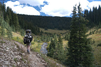
 After a rest stop, Susie and I dropped to an easy crossing of the creek (dry foot) and began a climb away from the creek at the lower (northern) end of a meadow that seemed to stretch forever. We were suitably impressed. The climb took us to the edge of timber and we noticed Lance disappearing into the next patch of trees. So we were not terribly far behind. We soon passed Lance, as he had stopped to commune with nature, and continued a gentle climb in woods along the meadow. The wind had picked up considerably, and we were really enjoying the protection of the trees. We pulled around a corner in the trail, and we could see a stack of packs, along with about half our crew. Sue, Tim, and Diane we about 100 meters distant, walking through a notch in the rock to where I presumed Blue Lake began. It was only 4:20 pm, and it was time to look for campsites. We were There! The wind was brutal, and cover was the name of the game. Sue reported back that there was nothing at the Lake that offered any protection in this near hurricane, and so many of the rest of us went off in search of protected campsites, likely as scarce as hen's teeth here. Susie and I took the luxury of staggering around, the weight of the packs temporarily lifted from our shoulders. I put on my Polartec goat herder's hat and Goretex jacket, to provide some modicum of refuge. In a few minutes, Lance reported that he had found a spot with enough flat spots on which to plant our five nylon houses. It was away from the Lake, but it was considerably less windy. Sounded like home for the night. We all grabbed our packs and headed down into the woods. We set up in a little clearing (356085 Easting, 4122661 Northing,), and it felt good to be out of the gale. I was pleased that we had made the climb in 5 hours or so, especially since this was the first day.
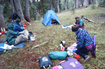
Next task was water and cleaning up. I had recalled that we had crossed a tiny rivulet before we got to the campsite area, so I took off in that direction. It was further than I had recalled, and tiny seemed to be the operative word. But, as Susie pointed out, it was a lot stronger source than we often have in the canyon country, so we should not be too critical. Despite the wind, I felt compelled to take a modest bath (No, I was not modest. The bath was.) It felt good to get my hair washed and the sweat off my back. I hauled the water back to camp in Susie's pink day pack, and dressed for dinner. Tonight, warmth won out over style. In addition to long underwear bottoms and Patagonia fuzzy pants, my upper gear consisted of multiple layers: Patagonia thin top, a cotton shirt, LL Bean nylon Wind Shirt followed by a Polartek pullover a down vest, and Marmot Goretex parka. I felt like a balloon, but a warm one. Except for Tim and Diane, we all pitched our tents pretty closely, so as to seek solace in proximity. Susie and I opted for a chicken and orzo dinner. It was one pot, made a lot, and was tasty. Bed time was an excuse to get out of the wind and relax, so it came before total darkness.
© Roger A. Jenkins, 2003