South San Juan Wilderness 2003
High, Wild and Windy
Getting testy
Wednesday, September 17
 Whew, another rough night. The wind howled and roared through the trees. It was really tough to sleep with all the noise. It had been a very clear night, with wonderful stars, but it was hard to get back to sleep after our sojourns into the bushes. So by first light, around 6:50, we were both up, stuffing sleeping bags and rolling pads. I think we were getting a bit frustrated, because we had been in such incredible locations, but just sitting out and relaxing was such a chore. I wish we knew what kind of weather system was causing such. We emerged, suited up like we were on a winter backpack, even though it was only 40 degrees outside. Breakfast was not all that relaxing, because it was easy to get chilled.
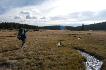
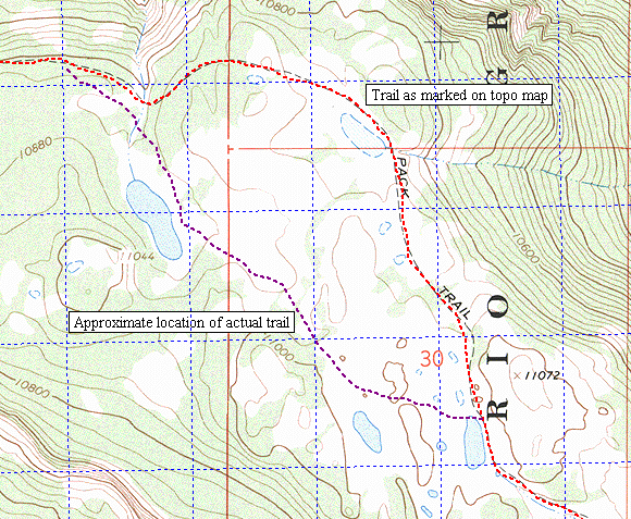
We were out of camp a few minutes before 9 am. We followed the trail as marked on the National Geographic/Trails Illustrated map east-northeast out of the bowl in which Victoria Lake sits. By the time we were about a mile to east, we were pretty spread out. (That is my code phrase for my net hiking speed being substantially slower than everyone else's.) Susie, ever patient, and I could see the crew across another huge meadow standing together and gestering in different directions. It seemed that they had to be to the NW of Alverjones Lake, so I could not figure out what the problem was. When we caught up, it seemed that there were a couple of different ideas as to how to proceed. We were east southeast of where trail 727, the one we wanted, splits off from Trail 775. But there was an obvious path heading to the immediate east of Alverjones Lake, and for some reason, Lance was bound and determined to take that route, even though it was obviously not the one on which we had intended to go. Ray took off to keep him company. Maybe the wind was starting to get to everyone, or maybe too much togetherness had already been had. To me, it seemed like a no-brainer, but then I was just pleased that folks had waited for us to catch up, rather than splitting up and have us watch two parties take off in different directions, not knowing which one to follow. In retrospect, I think I had unwittingly contributed to the problem, by incorrectly translating the location of trail 727 from the Trails Illustrated map to our topo maps on the near side of the Lake. Lance wanted to follow what I had marked, and everyone else wanted to follow the route on the Trails Illustrated (TI) map. To make it even more confusing, the actual USGS topo map shows a trail picking up about 500 meters south southeast of the Lake, along Rough Creek, but I am not convinced that there is really a trail in that specific location.
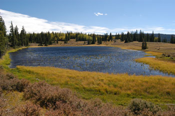 Well, no matter with all of this. We all met up again just a few minutes later, in a meadow about a kilometer SE of the Lake, where Rough Creek breaks out into the opening. All that "discussion" for nothing. Anyway, we all stuck together as the trail moved along through patches of trees, and open meadows. At this point, we were following a pretty definite trail, and were not really paying attention to the details of our route. The wind was still pretty brutal: as we crossed a meadow near 368500 E, 4114000 N, a wind gust nearly blew Susie off her feet, and Sue would later report that she had been knocked over by wind at the same meadow. Just lovely. As it got near lunch time, we decided we would stop, and find a little somethin' against the wind (The line in the Bob Seeger song was rolling over and over in my mind, I can assure you.) We found some trees that offered some shelter and a sunny spot, and decided to relax. Tim thought we were in one spot, and some of the rest us thought elsewhere. So we decided to have a look at the GPS. You would think that with multiple scientists and three GPS's we could figure out where we were. But alas, confusion reigned. My GPS was showing us as being someplace way off where the trail was, but right next to a lake, just like I thought we should be. Andy was showing us near the same spot, but not with the same coordinates. And Lance, well, he had the same reading as Andy, but showed us in a spot way different from the rest of us. Oh brother. Well, we decided that we were all correct, sort of. First, the primary problem was that the trail is not as shown on the map. By cursorily examining the terrain when I first stopped, I THOUGHT we were at the small lake near 370200 E, 4113785, because there was a lake right in front of me and we were on the Valle Victoria Trail, as marked on the TI map. But in fact, we were sitting at 369473 E, 4113496 N, looking at the lake that is just to the west maybe 50 meters. Andy was showing us at the same point, because he was using WGS84/NAD83 coordinates on his copy of TOPO, whereas I, being a "classic" kind of a guy, was using the NAD27 coordinate system. And, while Lance had printed out the maps that I had produced and converted to PDF files, he had failed to note that they were in NAD27 coordinates, and had never changed his GPS from the default setting of WGS84.
For those of you reading this that find this a pretty esoteric discussion, take a look at this link and you will see why it is critical to understand your coordinate system. The lake that we were actually at is dead center. The place we thought we were at, by looking at the terrain, is nearly a kilometer to the northeast. Ouch!! The differences between the two UTM coordinate systems can be a few hundred meters, enough to throw one way off. Anyone who plans to hike up here needs to come with map, compass, and terrain reading skills. And in fact, it is a perfect place to give your GPS a workout.
After lunch, we took off on the trail as it was on the ground, as opposed to the route marked on the map. Susie and I stopped to pump some water in a small creek, spotting our friends a hundred meter lead. Which they quickly converted into a 200 meter lead. The terrain was sufficiently undulating that even though they were not that far ahead, they were out of sight. Brother, we thought, maybe it was the wind, but for a hike that was supposedly downhill most of the day, we were sure going up often. Susie and I passed a lovely lake as we crested a small rise, the lake ringed with scattered aspens and evergreens, but covered with whitecaps. It would have been a nice place to stay for the night (it did seem kinda early to stop) but there seemed little protection from the wind. Within a few hundred meters, we came to our friends, waiting patiently for the slowpokes, out of the wind. Andy had gotten a fix with the GPS, and announced that a) we were back on the trail marked on the map and b) the lake we had just passed was the one at which we had originally planned to stop for the night. But we had already blown off the idea of staying high. We were ready for some trees and serious shelter.
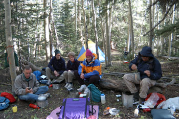 Before long, the trail began its descent through thick stands of aspen. It felt delightful to be out of the full force of the wind. By this time, our plan was to stop at the small pond that is near 372000 E, 4111432 N, assuming it had some flat places to erect some tents. The trail at this point was in miserable conditions, rocky and heavily eroded, due to its pitch, the lack of water bars, and the large amount of horse and cattle traffic that it gets. We arrived aobut 2:30 pm at the target pond, and it was, at least this late in the season, a marginal spot at best. The pond had a ring perhaps 40 feet wide of dried mud all around it. There is neither a visible inlet or outlet. At this time, another "discussion" erupted. I think everyone was getting a bit testy, shall we say, having endured about 100 continuous hours of heavy wind. Tim wanted to push on, so that he and Diane could get to a great campsite they knew about in a meadow just above the junction with the trail we were on, not a mile away, and do some fishing the next day. Lance was feeling like we had changed our plans to stay at the pond, and he did not want to be pushed further. Sue was wondering about the wind: if we got down to the meadow below, and the wind was as brutal, she was going to be upset. At least we had protection where we were. So T&D headed down the trail, and the rest of us decided to stay put. Well, actually, I was ready to move on, and Sue made an in-jest remark that Susie took seriously, and she was concerned that we were abandoning one set of friends for another. God!! The group dynamics were getting complex, even in a group where the youngest person was in his early 50's!
So Susie and I stayed up at our little pond with some of our friends, and spent some time trying to find a spot where you could step out on some rocks to get some water without stirring up the silt. Always the optimist (NOT!!), Susie indicated, and rightly so, that in canyon country, we had previously dealt with a whole lot less appetizing water sources. Bath time was followed by dinner of a wonderful Santa Fe chicken and rice. Andy reported that the high for the day was 56 degrees, setting (albeit at a lower elevation) the high temperature to date on the trip. Shades of the Pasayten Wilderness trip three years ago! We chatted for a while after dinner, but eventually drifted off to bed, not wanting to make a fire in the heavy woods.
© Roger A. Jenkins, 2003