
Paria Hackberry Traverse 2008
Ch-ch-ch-ch-Changes
On to Crack Spring Camp
Tuesday, April 29 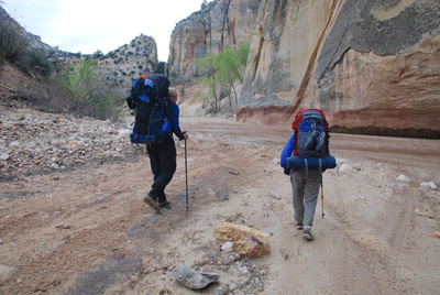 We had a pretty leisurely morning: light clouds and
concern for Ron was our excuse. Ron said that at this point, given how
he felt, he had decided, after going downstream just a few miles to
the next camp, he would turn around and exit the canyon. He admitted
feeling a bit better, but only marginal. Certainly not up to doing the
plateau crossing that loomed 2 days in the future. But he was willing
to go down as far as Crack Spring, our next camp.
We had a pretty leisurely morning: light clouds and
concern for Ron was our excuse. Ron said that at this point, given how
he felt, he had decided, after going downstream just a few miles to
the next camp, he would turn around and exit the canyon. He admitted
feeling a bit better, but only marginal. Certainly not up to doing the
plateau crossing that loomed 2 days in the future. But he was willing
to go down as far as Crack Spring, our next camp.
Now, if any reader is looking on the map, one might wonder: why go a mere 3.25 miles or so to another camp, when you could go further. Good question. Basically, it had to do with plans to take time to explore slots, nooks and crannies along the way, to take advantage of a wonderful spring, and basically, take it easy. This was, after all, actual vacation for many of the folks. Besides, if one did not feel like they were getting an adequate workout, one could always turn upstream along the Paria, and hike to Rock Springs Creek, or several other interesting spots upstream.
 Nevertheless, keeping with the
"relaxed fit" atmosphere of today's walk, Susie and I did not pull out
of camp until 9:33 am. Pretty lazy, I'd say. Sue and Andy and a few
others were up ahead, looking for a pictograph panel that Kelsey
reports is 300 meters or so upstream of the mouth of Sheep Creek. Sue
scoured the obvious spot, but was unable to find anything. Sue yelled
down to us that it was not fruitful to climb up, so we followed her
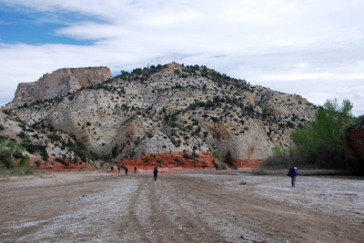
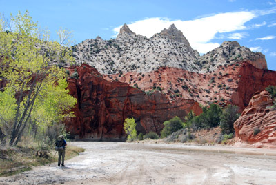
suggestion. Arriving at the mouth of Sheep Creek, one is immediately
taken by the appearance of the red Navajo layer of sandstone. The
contrast between the two layers is quite dramatic. And there is no
mixing at all. Just a demarcation point: below, the sandstone is
white, and above, it is a deep red. One other dramatic change: the
river canyon bed was just covered with 4WD tracks. We had never seen
anything like this 14 years ago, and were taken with how the sheer
volume of tracks detracts from the wilderness experience.
(Fortunately, we would see no vehicles, and that helped a lot. OK, we
found parts of a vehicle, which gave us cause for joy. The darn thing
apparently had sunk in quicksand. What a shame....)
Nevertheless, keeping with the
"relaxed fit" atmosphere of today's walk, Susie and I did not pull out
of camp until 9:33 am. Pretty lazy, I'd say. Sue and Andy and a few
others were up ahead, looking for a pictograph panel that Kelsey
reports is 300 meters or so upstream of the mouth of Sheep Creek. Sue
scoured the obvious spot, but was unable to find anything. Sue yelled
down to us that it was not fruitful to climb up, so we followed her
suggestion. Arriving at the mouth of Sheep Creek, one is immediately
taken by the appearance of the red Navajo layer of sandstone. The
contrast between the two layers is quite dramatic. And there is no
mixing at all. Just a demarcation point: below, the sandstone is
white, and above, it is a deep red. One other dramatic change: the
river canyon bed was just covered with 4WD tracks. We had never seen
anything like this 14 years ago, and were taken with how the sheer
volume of tracks detracts from the wilderness experience.
(Fortunately, we would see no vehicles, and that helped a lot. OK, we
found parts of a vehicle, which gave us cause for joy. The darn thing
apparently had sunk in quicksand. What a shame....)
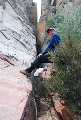 I could see a small crack that
looked interesting on the east side of the river, and decided to go
over to investigate. Ron dropped his pack in the center of the river
bed, and headed in the opposite direction to explore a slot that would
be next on my list. The small crack on the near side of the river
proved to be pretty short, but it was interesting nonetheless. And
there was a nice Claret Cup cactus on the rock shelf nearby. Then, we
headed over to the slot that Ron was exploring. It was short but
twisty, and proved to be a nice diversion. I suspect that with some
climbing, the slot would go on for a ways.
I could see a small crack that
looked interesting on the east side of the river, and decided to go
over to investigate. Ron dropped his pack in the center of the river
bed, and headed in the opposite direction to explore a slot that would
be next on my list. The small crack on the near side of the river
proved to be pretty short, but it was interesting nonetheless. And
there was a nice Claret Cup cactus on the rock shelf nearby. Then, we
headed over to the slot that Ron was exploring. It was short but
twisty, and proved to be a nice diversion. I suspect that with some
climbing, the slot would go on for a ways.
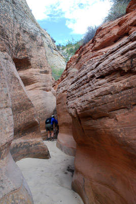
As the clouds started dissipating, the day began to warm. Ron, Susie and I were in the lead at this point, enjoying the demarcation between the white and red sandstone. Next on the sightseeing list was an interesting crack about a mile downstream (east side of the Paria) from the confluence of Sheep Creek and the river. Susie and I had been in it 14 years ago, and inside the crack, there is a huge slab of sandstone, just a few feet thick and perhaps a hundred feet high that has exfoliated and sits on the floor of the slot/crack. What struck me was the amount of grass growing on the floor of the crack. And trees. I simply did not remember such. (Upon returning home and looking at the 14 year old photos, the reason why I don't remember the grass is that it was not there. The grass had come since the mid-1990's. Ch-ch-ch-ch-changes.) I think all of the rest of our crew arrived as we were coming out. Ron announced he was getting short on energy, and had decided to head directly for camp, rather than doing much more sightseeing. I felt we should try to keep him in sight, without being "overly protective."
 About this point, the wind
started picking up. It would slow down, and then blow like crazy for a
while. Gusts came from all points of the compass. It kept one cool,
but all the sand blowing around was more that a bit annoying. About a
half mile down from the crack we had inspected, there is a neat slot
on the west side of the canyon, protected by vegetation and quick
sand, that we went into a bit on the previous trip. With all the
vegetation and mud to negotiate, the wind blowing, and Ron getting
further out ahead, we decided to pass up the entrance to Assay Canyon.
Kelsey reports that it is easy to bypass the slot (with waist deep
water in it) by climbing to the right and re-entering a few hundred
meters beyond the mouth. It turns out, despite the fact that I had
marked the slot on the group maps, no one decided to fight the
vegetation and mud that day.
About this point, the wind
started picking up. It would slow down, and then blow like crazy for a
while. Gusts came from all points of the compass. It kept one cool,
but all the sand blowing around was more that a bit annoying. About a
half mile down from the crack we had inspected, there is a neat slot
on the west side of the canyon, protected by vegetation and quick
sand, that we went into a bit on the previous trip. With all the
vegetation and mud to negotiate, the wind blowing, and Ron getting
further out ahead, we decided to pass up the entrance to Assay Canyon.
Kelsey reports that it is easy to bypass the slot (with waist deep
water in it) by climbing to the right and re-entering a few hundred
meters beyond the mouth. It turns out, despite the fact that I had
marked the slot on the group maps, no one decided to fight the
vegetation and mud that day.
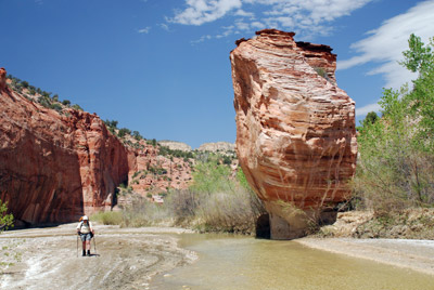
By the time we got to Lone Rock, or Standing Rock, or whatever you want to call it, the wind was making things pretty unpleasant. I remember seeing Ron pass the rock after taking a couple of photos, and being obscured completely by a cloud of blowing sand. Delightful. We stopped to take a couple of obligatory photos and then pressed on. We had decided to get to camp before we had a late lunch. We could see Ron up ahead, walking past where I thought I had marked the waypoint for the campsite. I was concerned that he was sufficiently tired that he was missing the obvious. As it turns out, he just was not sure where to come up out of the river bed and on to the bench. Likely story...... (Actually, it turns out I had marked the waypoint about 160 meters downstream of the point where camp actually was. Ron was being a good boy and going to where I had marked.)
 We pulled into the campsite
(12S, 409692 E, 4138480 N), well used for sure, a few minutes before 1
pm. It too was pretty sandy, probably a result of overgrazing by cows
and a lot of historical use, recent and otherwise. We suggested that
Ron take a small spot under some trees, where he would have some shade
for most of the afternoon. Susie and I took a broken shade spot
(pretty unbroken by late afternoon, unfortunately) and sat down to
enjoy some lunch. This was a bit late to eat, but the wind-driven sand
in the river bed made the option of eating earlier not attractive.
Next task was to go over and get some water at Crack Spring. I must
say, it was in its glory. I am not sure I have ever seen a spring in
the desert, with perhaps the exception of one in Lower Paria, a couple
of days downstream, that was producing as much water. The two inch
diameter pipe was running full. Amazing. Water nice and clear and
cold. Pretty good. We took a bunch of photos and then went back over
to camp, and watched Ron snooze and other members of our party dribble
into camp. Another disconcerting thing was that there was all sorts of
trash around the campsite; specifically large plastic bags (the size
one might put bark nuggets for mulch in) in the river bed and
littering the campsite. We determined that these bags had probably
been used for horse feed. Indeed, Will would later find some sort of
stash, with a shovel, plastic bin, and all manner of other crap stored
under a rock ledge. Maybe the stash-ee had his plastic bags blow
around in the wind. We considered burning the entire pile of stuff,
but decided it would just piss off the owner, even though he had
already pissed us off by considering a wilderness area his private
storage locker. Some folks simply don't get it. Susie took photos of
the trash, which we will probably send to the BLM, and remind them
that grazing leases don't come with an option to trash the
countryside.
We pulled into the campsite
(12S, 409692 E, 4138480 N), well used for sure, a few minutes before 1
pm. It too was pretty sandy, probably a result of overgrazing by cows
and a lot of historical use, recent and otherwise. We suggested that
Ron take a small spot under some trees, where he would have some shade
for most of the afternoon. Susie and I took a broken shade spot
(pretty unbroken by late afternoon, unfortunately) and sat down to
enjoy some lunch. This was a bit late to eat, but the wind-driven sand
in the river bed made the option of eating earlier not attractive.
Next task was to go over and get some water at Crack Spring. I must
say, it was in its glory. I am not sure I have ever seen a spring in
the desert, with perhaps the exception of one in Lower Paria, a couple
of days downstream, that was producing as much water. The two inch
diameter pipe was running full. Amazing. Water nice and clear and
cold. Pretty good. We took a bunch of photos and then went back over
to camp, and watched Ron snooze and other members of our party dribble
into camp. Another disconcerting thing was that there was all sorts of
trash around the campsite; specifically large plastic bags (the size
one might put bark nuggets for mulch in) in the river bed and
littering the campsite. We determined that these bags had probably
been used for horse feed. Indeed, Will would later find some sort of
stash, with a shovel, plastic bin, and all manner of other crap stored
under a rock ledge. Maybe the stash-ee had his plastic bags blow
around in the wind. We considered burning the entire pile of stuff,
but decided it would just piss off the owner, even though he had
already pissed us off by considering a wilderness area his private
storage locker. Some folks simply don't get it. Susie took photos of
the trash, which we will probably send to the BLM, and remind them
that grazing leases don't come with an option to trash the
countryside.
The air temp would build to near 80 degrees by late afternoon. That meant it felt like 100 in the sun. A great time to sit around camp, chat, and worry about Ron. I told Sue that my suggestion would be, since we had it, to give him another day, encourage him to hike down to the mouth of Deer Creek with us. That would still give him plenty of time to turn around and hike out if he still felt really crappy on Thursday morning. I also spent some time talking with Ron, asking him to consider drinking more water and eating more protein next time.
 Fortunately, the river water, as
Kelsey reports it to be sometimes, was clear as a mountain stream.
What a pleasant change since last time. One did not mind bathing it
in, although I noticed that my hands were suffering due to the
alkaline water, and my forgetting to bring hand cream with me. Stupid
stupid. We took a nice bath upstream in late afternoon, and then
returned to our laborious task of sitting around camp and chatting.
Never a bad thing. Actually, my feet were already getting beaten up. I
was wearing the same pair of LL Bean Goretex hiking boots that I wore
on the canyon trip last year, and I think that although the boots are
a "wide" width, the toe box is still too small. They had been keeping
my feet nice and dry, but I had serious blisters on both sets of toes.
Pretty uncomfortable, but what can you do? Except sit around and
relax, right?
Fortunately, the river water, as
Kelsey reports it to be sometimes, was clear as a mountain stream.
What a pleasant change since last time. One did not mind bathing it
in, although I noticed that my hands were suffering due to the
alkaline water, and my forgetting to bring hand cream with me. Stupid
stupid. We took a nice bath upstream in late afternoon, and then
returned to our laborious task of sitting around camp and chatting.
Never a bad thing. Actually, my feet were already getting beaten up. I
was wearing the same pair of LL Bean Goretex hiking boots that I wore
on the canyon trip last year, and I think that although the boots are
a "wide" width, the toe box is still too small. They had been keeping
my feet nice and dry, but I had serious blisters on both sets of toes.
Pretty uncomfortable, but what can you do? Except sit around and
relax, right?
When it was time for dinner, we had thought about setting up on some logs that were set around an old fire ring, but the wind was being a pain again, so we opted to go to a more sheltered spot, under a rock overhang, where Carol and Barbara had set up their respective sleeping areas. The overhang offered protection from the wind, and also a chance to be crushed by falling rock. Carol used his trekking pole to dislodge several neck breakers, but we all decided in the end that it was easier to hope that this would NOT be the day that the big slab would decide to break loose. Dinner tonight was thin spaghetti with pesto sauce, pine nuts and cheese. This ended up being the tastiest dinner we would have, simply because the pasta really soaked up the flavor of the pesto. OK, I probably could have eaten more of it, but you get what you get when we are carrying only 18 pounds of food for a week. After we went to bed, Susie and I discussed options for dealing with Ron's planned exit from the trip. We eventually figured that tomorrow, all would become obvious, so we rolled over and went to sleep.
To view supplemental photos of this trip, go to our TwoHikers SmugMug gallery.
To view additional and different photos of the trip, go to Will's SmugMug photo gallery.
© Roger A. Jenkins, Suzanne A. McDonald, 2008, 2016