
Paria Hackberry Traverse 2008
Ch-ch-ch-ch-Changes
Down Canyon to Deer Creek
Wednesday, April 30 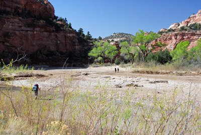 Another luxuriously slow morning in camp, since we knew
we only had to go a couple of miles down canyon. The purpose of doing
things this way was a) to have an easy day prior to our traverse
across the plateau b) have plenty of time for poking around in lower
Deer Creek Canyon and c) be able to take the time to actually find the
start of the CCC trail, which we planned to use tomorrow to climb out
of the Paria River canyon and begin the traverse over to Hackberry. I
was able to talk Ron into coming down that far with us at least. It
would give him another day of "rest" and get him at least to some
pretty scenery. Susie and I pulled outta camp a bit after 9:30 and
walked all the way across the canyon to Crack Spring. Susie had
decided that we ought to practice loading our packs with significant
amounts of water, just to see how it would all fit a) tomorrow on the
plateau traverse and b) the last full day of the trip, when we would
have to carry all the water we would need for 24 hours. So Susie
filled both her regular drinking Platypus (1 liter) plus the 4 liter
one we had gotten for this trip. I filled both my water bottle (1 L),
my Platypus (1.5 L) and then put a couple of liters in our water bag.
So when we finally hoisted our packs and left the spring, the packs
were fairly heavy.
Another luxuriously slow morning in camp, since we knew
we only had to go a couple of miles down canyon. The purpose of doing
things this way was a) to have an easy day prior to our traverse
across the plateau b) have plenty of time for poking around in lower
Deer Creek Canyon and c) be able to take the time to actually find the
start of the CCC trail, which we planned to use tomorrow to climb out
of the Paria River canyon and begin the traverse over to Hackberry. I
was able to talk Ron into coming down that far with us at least. It
would give him another day of "rest" and get him at least to some
pretty scenery. Susie and I pulled outta camp a bit after 9:30 and
walked all the way across the canyon to Crack Spring. Susie had
decided that we ought to practice loading our packs with significant
amounts of water, just to see how it would all fit a) tomorrow on the
plateau traverse and b) the last full day of the trip, when we would
have to carry all the water we would need for 24 hours. So Susie
filled both her regular drinking Platypus (1 liter) plus the 4 liter
one we had gotten for this trip. I filled both my water bottle (1 L),
my Platypus (1.5 L) and then put a couple of liters in our water bag.
So when we finally hoisted our packs and left the spring, the packs
were fairly heavy.
 But it was a short run down to
the mouth of Deer Creek, just a tad over two miles. And pretty easy
walking, given that a lot of 4WD's had packed the river bed surface.
Most of the group was at a petroglyph panel just upstream of the mouth
of Deer Creek. I did not remember the panel, but looking at photos
from the previous trip, I should have remembered it. After a few
obligatory photos, Barbara and I set off looking for a campsite, and
we found one near where I had marked it on our maps (ok, I was "off"
by 83 feet). I had "remembered" (albeit incorrectly) the group camping
previously further up into Deer Creek. However, the memory of
"further" might have been a result of the fact that we were coming
from downstream, and in fact, the actual campsite we used (same one on
both trips, at 12S, 409089 E, 4136102 N ) is 300 meters or so upstream
from the point where Deer Creek actually joins the Paria. The actual
approach to the campsite, if you are heading upstream, is complicated
by the fact that some rancher has cordoned off a several acre parcel
of land right above the mouth of Deer Creek with a barbed wire fence,
so it is impossible to get into Deer Creek at the Paria and follow it
up to the campsite (Deer Creek is blocked by the fence). Instead, you
have to go further up the Paria, to the bench on which the petroglyph
panel is found, then cut back to Deer Creek and go up it a short
distance. What a pain. I made a mental note to let the BLM know about
this to make sure that use is legal.
But it was a short run down to
the mouth of Deer Creek, just a tad over two miles. And pretty easy
walking, given that a lot of 4WD's had packed the river bed surface.
Most of the group was at a petroglyph panel just upstream of the mouth
of Deer Creek. I did not remember the panel, but looking at photos
from the previous trip, I should have remembered it. After a few
obligatory photos, Barbara and I set off looking for a campsite, and
we found one near where I had marked it on our maps (ok, I was "off"
by 83 feet). I had "remembered" (albeit incorrectly) the group camping
previously further up into Deer Creek. However, the memory of
"further" might have been a result of the fact that we were coming
from downstream, and in fact, the actual campsite we used (same one on
both trips, at 12S, 409089 E, 4136102 N ) is 300 meters or so upstream
from the point where Deer Creek actually joins the Paria. The actual
approach to the campsite, if you are heading upstream, is complicated
by the fact that some rancher has cordoned off a several acre parcel
of land right above the mouth of Deer Creek with a barbed wire fence,
so it is impossible to get into Deer Creek at the Paria and follow it
up to the campsite (Deer Creek is blocked by the fence). Instead, you
have to go further up the Paria, to the bench on which the petroglyph
panel is found, then cut back to Deer Creek and go up it a short
distance. What a pain. I made a mental note to let the BLM know about
this to make sure that use is legal.
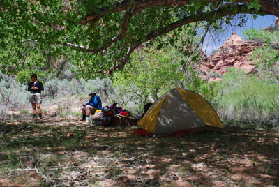
 All this said, the campsite
would be the best of our trip. It had nice albeit sparse, grass, big
cottonwoods for shade and large chunks of fallen slickrock that are
always nice for keeping some of your gear sand-free. OK, maybe
partially free. In the wind that prevailed, everything was coated with
a fine grit. We all got our tents set up (lots of room to do so), had
lunch, and listened to Ron say he was feeling much better, and he
thought he would be fine for the plateau traverse tomorrow. That was
reassuring, since, in a way, we had all been surprised that he had not
recovered more quickly. But everyone is different, and we were happy
he was "back in the fold."
All this said, the campsite
would be the best of our trip. It had nice albeit sparse, grass, big
cottonwoods for shade and large chunks of fallen slickrock that are
always nice for keeping some of your gear sand-free. OK, maybe
partially free. In the wind that prevailed, everything was coated with
a fine grit. We all got our tents set up (lots of room to do so), had
lunch, and listened to Ron say he was feeling much better, and he
thought he would be fine for the plateau traverse tomorrow. That was
reassuring, since, in a way, we had all been surprised that he had not
recovered more quickly. But everyone is different, and we were happy
he was "back in the fold."
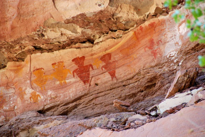
After lunch, everyone seemed to be up for a hike up Deer Creek. First
stop was a wonderful pictograph panel just a couple of hundred meters
upstream from where we were camped, on canyon right. This is the
famous panel where some idiot tried to hack a pictograph out of the
canyon wall with a hatchet or something. His IQ was probably equal to
the number of pictographs he had successfully removed. While we were
poking around below the panel, Sue found a metal box with a log book
inside it. Apparently, the previous weekend, Bud Light had sponsored
some "Canyon Discovery" ATV group in Paria. 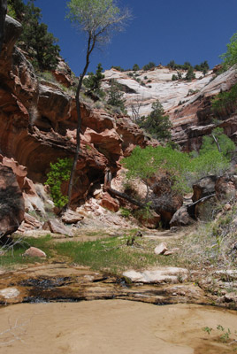 No wonder there had been a lot of tracks on the canyon
bottom. Now, I have never had anything against Bud Light, other than
it, like Coors Light, tastes more like beer-flavored soda pop. But
now, Anheuser-Busch has at least one strike against it.
No wonder there had been a lot of tracks on the canyon
bottom. Now, I have never had anything against Bud Light, other than
it, like Coors Light, tastes more like beer-flavored soda pop. But
now, Anheuser-Busch has at least one strike against it.
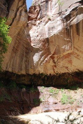
We all poked along, and came to a second large panel of pictographs, a good ways above the floor of the canyon. The figures were dramatic, and had not faded too much. In general, once you get above the choking vegetation of the first few hundred meters in the canyon, Deer Creek becomes quite lovely. Lots of nice flowing water, a few rock shelves in the creek bed, interesting canyon walls, and lots of wildflowers blooming. A great place to spend a chunk of the afternoon. Most of us got to the blocking pouroff a bit before 2 pm. It is located approximately 1.5 miles up canyon from the campsite near 12S, 407945 E, 4137680 N (it is hard to say exactly where it is because of the inability of the GPS to get a good reading). Big changes had occurred at the pour off as well. Previously, there was a lovely deep emerald pool at its base (see http://www.twohikers.org/CanyonCountry/Paria94/Paria94_day4.htm). But times change, and so do the canyons. Now, there is sort of a gray small pool, not very large, and looking like it is filling in. Nowhere as pretty as it used to be, but maybe a hundred-year flood in the next few years will fix all that. Nevertheless, you still cannot go wrong spending some time in the lower mile and a half of Deer Creek.
 Susie and I turned around a bit
after 2 pm. We would later learn that Terri, Will and Barbara were
able to climb out of the canyon using a route that starts near 12S,
408456 E, 4136815 N. They were looking to find a panel of sheep
drawings that is supposed to be found somewhere up in that direction,
but they were not able to find it. Meanwhile, back at the ranch, Susie
and I got back to camp in about 50 minutes, walking about as fast as
we wanted to walk. We dropped our cameras, picked up our bath stuff,
and headed back to the river to clean up (again, Deer Creek is blocked
by this damn barbed wire enclosure. We got out to the river, and the
wind was roaring big time. Reminded us of our South
San Juans trip a few years ago. We put our bath stuff in a safe
place and headed down the river to see if we could find where the CCC
trail starts. I had spent some time staring at satellite and aerial
photos, and felt like I had a pretty good fix on it. It turns out that
even a blind hog can find an acorn, occasionally, that is. The
waypoint I had set (12S, 409666 E, 4135593 N) was about 110 feet from
where the route actually takes off. If you don't have a GPS, there is
a large chunk of sandstone at the edge of the river bed. If you look
above that rock, you can see a faint trail-like way climbing up
steeply. Susie and I built a little rock cairn at that point, but not
sure it will last very long.
Susie and I turned around a bit
after 2 pm. We would later learn that Terri, Will and Barbara were
able to climb out of the canyon using a route that starts near 12S,
408456 E, 4136815 N. They were looking to find a panel of sheep
drawings that is supposed to be found somewhere up in that direction,
but they were not able to find it. Meanwhile, back at the ranch, Susie
and I got back to camp in about 50 minutes, walking about as fast as
we wanted to walk. We dropped our cameras, picked up our bath stuff,
and headed back to the river to clean up (again, Deer Creek is blocked
by this damn barbed wire enclosure. We got out to the river, and the
wind was roaring big time. Reminded us of our South
San Juans trip a few years ago. We put our bath stuff in a safe
place and headed down the river to see if we could find where the CCC
trail starts. I had spent some time staring at satellite and aerial
photos, and felt like I had a pretty good fix on it. It turns out that
even a blind hog can find an acorn, occasionally, that is. The
waypoint I had set (12S, 409666 E, 4135593 N) was about 110 feet from
where the route actually takes off. If you don't have a GPS, there is
a large chunk of sandstone at the edge of the river bed. If you look
above that rock, you can see a faint trail-like way climbing up
steeply. Susie and I built a little rock cairn at that point, but not
sure it will last very long.
We then headed back to clean up in the gale. Susie actually found a large boulder that offered shelter from the wind - sort of. But anything was a help. It was definitely cooler this day, with a high reaching the high 60's. The cool down plus the gusty winds suggested to me that a front was moving through, as predicted for this time period. We had hoped that the weather for our traverse day would be cool, and it was looking like that might be the case. Back in camp, we could tell that Ron was feeling foxy, and was ready to take on tomorrow. He had hiked well all afternoon. We decided we would keep the water we collected at the spring for our long hike tomorrow, so we pumped some more for dinner. We all tried to get in a sheltered spot to get out of the wind gusts, but it was tough to be wind free. Dinner for us tonight was orzo, with chicken and freeze dried peas. I could tell Ron was feeling better, because he made tortilla-based pizzas again. We spent the evening after dinner getting our gear ship shape and ready to move quickly in the morning. The plan was for everyone to get up by 6 am, and get outta camp by 8. We suspected it would be a long day. We had NO idea......
To view supplemental photos of this trip, go to our TwoHikers SmugMug gallery.
To view additional and different photos of the trip, go to Will's SmugMug photo gallery.
© Roger A. Jenkins, Suzanne A. McDonald, 2008, 2016