
Paria Hackberry Traverse 2008
Ch-ch-ch-ch-Changes
The Traverse
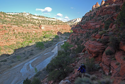
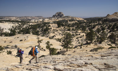
Thursday, May 1 The wind came in mega gusts throughout the night. We were glad that we had elected not to try to spend the night camped on the plateau, since we would have been even more exposed than down where we were, sheltered in Deer Creek. But you could hear the wind roar on and off all night, and smash into camp like a freight train. Fortunately, our Sierra Designs Hyperlight AST (the two person model) is extremely sturdy in high winds. No flapping, no rattling, no nothin. Tough little tent. And hard to get out of at 6 am, especially if the wind is blowing and it is 34 degrees out. Ouch!!, as Sarah Boomer would exclaim.
 Susie and I "cooked" breakfast
(that means boiling water for coffee and making some Crystal light
juice substitute, while eating cold granola) near our tent while we
packed up, trying to stay warm in the wind. We were underway by 7:50
am, headed for the river. We had to guide some folks over to the start
of the so-called CCC trail, because if you are on the far side of the
river, it is hard to see where it starts. We started our climb. I was
dressed in long pants, a long sleeve shirt, wind shirt, fleece goat
herder hat and fleece gloves. It would be pretty cool, until we
climbed up into the sun. At one point, Sue yelled from ahead that the
trail just petered out. I looked ahead and looked up the switchbacks,
and yelled back: Maybe that is because you are not on the trail! (She
had missed a switchback, which is easy to do.) Essentially, the trail
just switch backs sharply up the face of the canyon wall. No serious
exposure, but you do gain elevation fast. Before long, I climbed up
into the sun, and exclaimed that I felt like I was in the end of the
first big movie that George Lucas made: THX 1138. I noted that we were
less than a hundred feet from the second waypoint I had set, so we, or
I, was doing pretty good. We all gathered at the first point where the
first top out is (12S, 409984 , 4135443 N), rested briefly, adjusted
clothing and then headed out. We had made barely a mile from camp and
had spent over an hour doing so.
Susie and I "cooked" breakfast
(that means boiling water for coffee and making some Crystal light
juice substitute, while eating cold granola) near our tent while we
packed up, trying to stay warm in the wind. We were underway by 7:50
am, headed for the river. We had to guide some folks over to the start
of the so-called CCC trail, because if you are on the far side of the
river, it is hard to see where it starts. We started our climb. I was
dressed in long pants, a long sleeve shirt, wind shirt, fleece goat
herder hat and fleece gloves. It would be pretty cool, until we
climbed up into the sun. At one point, Sue yelled from ahead that the
trail just petered out. I looked ahead and looked up the switchbacks,
and yelled back: Maybe that is because you are not on the trail! (She
had missed a switchback, which is easy to do.) Essentially, the trail
just switch backs sharply up the face of the canyon wall. No serious
exposure, but you do gain elevation fast. Before long, I climbed up
into the sun, and exclaimed that I felt like I was in the end of the
first big movie that George Lucas made: THX 1138. I noted that we were
less than a hundred feet from the second waypoint I had set, so we, or
I, was doing pretty good. We all gathered at the first point where the
first top out is (12S, 409984 , 4135443 N), rested briefly, adjusted
clothing and then headed out. We had made barely a mile from camp and
had spent over an hour doing so.
 The next goal was to climb
slightly and circumvent the head of the small side canyon that was
directly to the east of us. That we did, which involved a bit more
climbing and then one gully crossing. Not a lot of elevation loss and
gain, but I knew there were be many more of these. We stopped and
gathered up folks, who were getting strung out, and took a short rest
near 12S, 410513 E, 4136283 N. By now, it was 10:30 and we had only
come a little over a mile from the last stop. I was getting a bit
discouraged with our slow pace, but elected not to share that at this
point. A note here: it is probably easier to follow progress on the
PDF'd maps of the actual GPS tracks [Part
1 and Part 2](courtesy of
Ron)and maybe improve your own route.
The next goal was to climb
slightly and circumvent the head of the small side canyon that was
directly to the east of us. That we did, which involved a bit more
climbing and then one gully crossing. Not a lot of elevation loss and
gain, but I knew there were be many more of these. We stopped and
gathered up folks, who were getting strung out, and took a short rest
near 12S, 410513 E, 4136283 N. By now, it was 10:30 and we had only
come a little over a mile from the last stop. I was getting a bit
discouraged with our slow pace, but elected not to share that at this
point. A note here: it is probably easier to follow progress on the
PDF'd maps of the actual GPS tracks [Part
1 and Part 2](courtesy of
Ron)and maybe improve your own route.
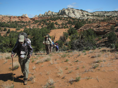
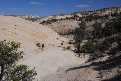
From that point, we worked our way around the small knob marked 5813 on the map, and continued in a northeasterly direction, going in and out of gullies. I had marked some waypoints, but we seemed to have decided that we could do a more direct route. After looking at the complex terrain on a topo with a clear head, I am not sure that such is the best approach. I probably should have marked more waypoints, trying hard to keep us from descending into and climbing out of drainages. One of the challenges in route finding in this area is the short range visibility: it is hard to see more than a hundred meters in most directions, simply because of all the juniper trees. It was slow going, and every time we stopped and reconnoitered, it burned through another five minutes. All those stops add up.
 We climbed through soft sand. It
was slow going. Thankfully, the day was still very cool. We finally
stopped for a lunch break around noon near 12S, 411991 , 4137764 N. I
now had started to remind people that we had a long way to go, and we
were nearing the half-way point of our daylight. Personally, I was
doing better than I had expected. Susie was doing super as well. While
we had not been doing much hiking since late September (OK, NO hiking
or backpacking, in contrast with our friends from Tennessee), the
constant cross-training winter regimen that we follow (cross country
track skiing, downhill skiing, exercise biking, and backcountry ski
touring) had really strengthened my legs. Susie just seemed to be
rockin' along, with no complaints. She MUST have been feelin' foxy.
We climbed through soft sand. It
was slow going. Thankfully, the day was still very cool. We finally
stopped for a lunch break around noon near 12S, 411991 , 4137764 N. I
now had started to remind people that we had a long way to go, and we
were nearing the half-way point of our daylight. Personally, I was
doing better than I had expected. Susie was doing super as well. While
we had not been doing much hiking since late September (OK, NO hiking
or backpacking, in contrast with our friends from Tennessee), the
constant cross-training winter regimen that we follow (cross country
track skiing, downhill skiing, exercise biking, and backcountry ski
touring) had really strengthened my legs. Susie just seemed to be
rockin' along, with no complaints. She MUST have been feelin' foxy.
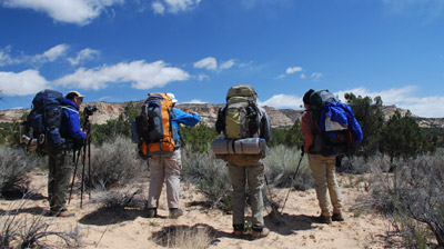
After lunch, we headed due north for about a half mile, until I realized that we were passing a waypoint which ended up being on the SE corner of what Kelsey calls Sugarloaf. We had gone to the south of it before, but looking down into the gully on its SE side, I simply did not have the stomach for losing anymore elevation than I had to. So we went around it to the north and headed in a generally easterly direction for the saddle. There were still plenty of gullies to cross, and I could tell, people were starting to get tired and testy. Will kept pointing out that we were north of the route we took in ‘94 and he was correct. He also claimed that had we stayed to the south of Sugarloaf, there would be fewer gullies to go in and out of, and less elevation at the time. I was skeptical of his claim, but after the trip, I compared our actual elevation gain between Sugarloaf and the saddle (499 feet, not net but actual climbing) vs the lower route and he was correct again, by a differential of 67 feet. Not a big difference but who wants to climb more on a day like this?
As we approached the saddle, I was out ahead, and Susie was just a couple of hundred meters behind me (I had the advantage of having my GPS turned on, so I could sorta go in an approximately straight line through all the juniper trees.) When I got to the saddle, I stopped in amazement. Here was another damned barbed wire fence. It stretched as far to the south as I could see. I certainly did not remember it from 14 years ago. (Another thing to ask the BLM.) It was tight and looked relatively new, and the only way to get around it was for me to take my pack off, carefully lift it over the fence, and then try to crawl through it without tearing my clothing. What a pain. I stopped, reloaded my Platypus hydration system, and waited for the others to catch up. Of course, Susie was right there, but it took a while to collect everyone. One of the huge mistakes we had made in 1994 was letting the group get separated. With challenging hiking (soft sand and seemingly continuous up and down), everyone has their own sustainable pace. Anyway, we did get together, and rested a bit. I noted that in 1994, this was near the area we had stopped for lunch. This time, we were leaving the saddle at 3:30 pm. Not good.
 Next, we needed to head east and
find the drainage that becomes Upper Death Valley. At this point, even
though it was late in the afternoon, I figured we could make up some
time, since I had recalled from Andy's retelling me about the route
that they used in ‘94 that all you had to do was get into Upper Death
Valley, and it was a cake walk. Well, as Hertz used to advertize: "Not
Exactly!" The first challenge was the fact that as you come out of the
saddle, it is too easy to start following the obvious drainage, and of
course, just like in ‘94, that takes you way to the NE of where you
want to be. I had a waypoint I as calling "T2" ( 12S, 415216 E,
4138067 N) that we needed to head for. Of course, that meant climbing
slightly out of the drainage and forcing our way to the east. Everyone
groaned, having hoped that it was "all downhill from here." So up we
climbed, but as it turned out, T2 was sitting in a small slickrock
cleft, that required a downclimb across steep slickrock to get to it.
From there, I had projected that we needed to go nearly due south.
Except that required some climbing. Everyone wanted to go down the
drainage to the south-southeast, simply because it looked like it
would take us to the same place we wanted to go. Theoretically.
Next, we needed to head east and
find the drainage that becomes Upper Death Valley. At this point, even
though it was late in the afternoon, I figured we could make up some
time, since I had recalled from Andy's retelling me about the route
that they used in ‘94 that all you had to do was get into Upper Death
Valley, and it was a cake walk. Well, as Hertz used to advertize: "Not
Exactly!" The first challenge was the fact that as you come out of the
saddle, it is too easy to start following the obvious drainage, and of
course, just like in ‘94, that takes you way to the NE of where you
want to be. I had a waypoint I as calling "T2" ( 12S, 415216 E,
4138067 N) that we needed to head for. Of course, that meant climbing
slightly out of the drainage and forcing our way to the east. Everyone
groaned, having hoped that it was "all downhill from here." So up we
climbed, but as it turned out, T2 was sitting in a small slickrock
cleft, that required a downclimb across steep slickrock to get to it.
From there, I had projected that we needed to go nearly due south.
Except that required some climbing. Everyone wanted to go down the
drainage to the south-southeast, simply because it looked like it
would take us to the same place we wanted to go. Theoretically.
I said, sarcastically (see, even I was getting a bit testy): "Fine, we will go down the drainage!" and I took off. But it did not last long. Will, who was behind me maybe 75 meters at this point, called out: "Hey, there looks like a trail up here." (heading south, out of the small drainage). I thought, THIS is the problem; we keep changing our approach. But it turned out that Will was dead on again. I hiked maybe 100 meters further, and was confronted by a deep chasm running north/south, near 12S, 415729 E, 4137465 N. No way could I continue, so I turned around, and saw most of the rest of the crew going up the way Will had turned. Indeed, he had found a pretty good trail, as these things go in this part of the world. Trail means that more than one person actually had walked this way in the past 20 years. We headed in a generally southerly direction for nearly a mile, making blessedly good time. We did stop for a brief rest break neat my original "T4" waypoint (12S, 415659 E, 4136371 N), so in reality, we had gotten to where we wanted to go in fine shape. Of course, we were still a few miles from our destination, but I figured at this point, we were in high cotton, as they say in the south.
 Deep shit is more like it! It
was now about 5 pm, and the country still had some surprises in store.
We left the rest spot and moved into the drainage that is officially
Upper Death Valley. As the "trail/path" crossed the drainage on
slickrock, we lost it, but it was just as well. A review of aerial
photos (after the trip) indicates that the trail begins to go to the
South Southwest and actually goes to the west of Cottonwood Butte, not
where we wanted to be. So we headed down Upper Death Valley, just
rolling along. Ignorance is bliss. Again, I thought that Andy had told
me that they had been down that drainage a long way 14 years ago, but
clearly, in retrospect, I should have checked more carefully.
Deep shit is more like it! It
was now about 5 pm, and the country still had some surprises in store.
We left the rest spot and moved into the drainage that is officially
Upper Death Valley. As the "trail/path" crossed the drainage on
slickrock, we lost it, but it was just as well. A review of aerial
photos (after the trip) indicates that the trail begins to go to the
South Southwest and actually goes to the west of Cottonwood Butte, not
where we wanted to be. So we headed down Upper Death Valley, just
rolling along. Ignorance is bliss. Again, I thought that Andy had told
me that they had been down that drainage a long way 14 years ago, but
clearly, in retrospect, I should have checked more carefully.
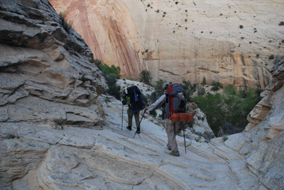
A&S were maybe 75 meters ahead of me. They turned a slight bend to the right, and stopped dead in their tracks. They did not like what they saw: a big pouroff, (between the "E" and the "A" in Upper Death Valley (UDV) on the USGS quad) and simply no easy way around it, spanning the drainage. To put it bluntly - and why not - we were screwed. The only way around this was to climb up out of the drainage, and head south. Damn!! And I had just been congratulating myself that we were not going to get up into the drainages that Susie, George, and I had to deal with 14 years ago. It wasn't much of a climb, probably only a hundred feet or so in soft sand, but at this point, any climb was too big. By the time I got to the top, Ron, now out ahead (boy, I need to get "sick" like he had been ....), had already dropped to the floor of the interceding gully (12S, 416260 E,4136014 N). He yelled back and asked if we wanted him to drop back to the north, into the UDV drainage, and check to see if we were pour-off free for a bit. I yelled back no, once I looked at how hard it would be for him to descend to the drainage floor from where he stood. We simply could not afford the time it would take for him to check it out. The two side drainages (the one we stood at the west rim of, and the one beyond, while not pleasant, I remembered as being do-able). At this point, we had to go with the known situation, especially since Andy told me that he and Sue had NOT gone this way 14 years ago.
So we all started the slow process of climbing down to the floor of the gully, and then up to its eastern flank. When we got to rim of the next one (12S, 416493 , 4136029 N), we could see it was even more "serious." The drop into it was steep, but Susie started to descend. Ron kept yelling at her that it appeared as though the bottom had an impassable cleft in it, and so he was bearing right, and began to do a traversing climb of a slope that was covered with manzanita. I followed Ron, but it was not pleasant. And naturally, we were still climbing. I turned to my left and saw that Susie had already crossed the gully floor, and that she was shooting up this steep slickrock slab to the eastern rim of the gully. In a few minutes, I could see that others were following her, but that Andy and Sue were doing the same miserable climbing traverse that Ron had convinced me to do. After more thrashing through the shin tangle, and more climbing, several of us finally gathered at a view point, near 12S, 416687 , 4135609 N. The sun was sinking lower in the sky, and Andy brushed by us, claiming he had to get his pile jacket on, because he was getting cold.
 Sue raised the issue, with
Carol, Will, and Barbara behind us, of the possibility of spending the
night up here, since she felt that those three were moving so slowly.
Boy, that did not sound appealing at all. I looked at my watch, and it
was coming up on 6:30. We still had a good 100 minutes of daylight,
and I felt like we could make it. We were only about 1.5 miles from
the waypoint which would mark the entrance to the little side canyon
where we could start our descent into Hackberry. From that point, the
floor of Hackberry should be only 15 - 20 minutes away. I could see
Will coming up just to my north, and queried as to where Barbara and
Carol were. He pointed out that they were right behind him. I looked
and he was right: about 50 feet behind him. I asked them how they
felt, and Carol wise-cracked: "Well, I think I got it in me if it is
not too harder than what we have done!" So it was clear that we would
move on.
Sue raised the issue, with
Carol, Will, and Barbara behind us, of the possibility of spending the
night up here, since she felt that those three were moving so slowly.
Boy, that did not sound appealing at all. I looked at my watch, and it
was coming up on 6:30. We still had a good 100 minutes of daylight,
and I felt like we could make it. We were only about 1.5 miles from
the waypoint which would mark the entrance to the little side canyon
where we could start our descent into Hackberry. From that point, the
floor of Hackberry should be only 15 - 20 minutes away. I could see
Will coming up just to my north, and queried as to where Barbara and
Carol were. He pointed out that they were right behind him. I looked
and he was right: about 50 feet behind him. I asked them how they
felt, and Carol wise-cracked: "Well, I think I got it in me if it is
not too harder than what we have done!" So it was clear that we would
move on.
I told the crew: "Look. All we gotta do is head for T8!" Of course, "where the hell is T8?" was a pretty obvious reply. Susie told me that I had to figure out something in the distance that we could hike toward, since the juniper on the bench across which we would be hiking were so thick that long range visibility at head height was obscured. I looked across toward the high walls way on the other side of Hackberry, and said: "See that crack in the high canyon walls? Keep that right in front of you, and just keep hiking." So they did. Most folks took off like rockets. It was about 6:45 pm, and a gentle downgrade for the next mile and a half awaited us. I knew I was running out of battery power in my GPS, but I would turn it on occasionally, having set it to Go To "T8" (12S, 418168 E, 4133840 N). I confess that after a day of feeling like we had been hiking thru cold molasses, it was uplifting to be hiking at a normal trail speed. I would look at my GPS's distance to go: 1.1 miles, 0.7 miles, 0.4 miles, 0.2 miles. At 300 feet or so, I broke out into the open, and saw others at the head of the gentle canyon we would have to descend. They were discussing which side of the canyon to descend. I could see Susie pointing, but lacked the vocal power at this point to reinforce what I knew she was telling them. You have to begin the descent staying on the north side of this little side canyon. They took off, and I could see the spot where the cow trail went. We had it made in the shade. Ok, in the dusk, but, whatever. I had thought during the hike today: boy, my left knee is gonna be fried after this hike today, and the descent seemed to confirm such. If I side stepped down, with my right leg leading and left knee bending, the latter really hurt. So I switched positions, descending with a leading left leg, and that helped a lot.
 We got to the "crux" of the
descent, which is not much of a crux. I figured that if cows can
handle this, even a tired Roger should do it fine (Susie and I had
been up and down this 14 years ago, but I had forgotten the little
narrow spot that the route forces you thru. Next, a quick cut to the
north, a drop to actual dirt, a 180 degree turn to the right, and we
were down. It was 7:50 pm, exactly 12 hours after Susie and I had
started hiking. We knew that there was a small place to camp
downstream a few hundred meters (where most of the crew, but not
Susie, George, and I, had camped 14 years ago, and we pushed on to
that. It turns out that there was a lot more sand at the spot, and
more willows, but things had obviously changed in a lot of places, so
why not here as well. We ended up finding a few flat spots, up against
the canyon wall. Not great, not even good, but it was here, and that
was good enough. (12S, 418490 E, 4133312 N).
We got to the "crux" of the
descent, which is not much of a crux. I figured that if cows can
handle this, even a tired Roger should do it fine (Susie and I had
been up and down this 14 years ago, but I had forgotten the little
narrow spot that the route forces you thru. Next, a quick cut to the
north, a drop to actual dirt, a 180 degree turn to the right, and we
were down. It was 7:50 pm, exactly 12 hours after Susie and I had
started hiking. We knew that there was a small place to camp
downstream a few hundred meters (where most of the crew, but not
Susie, George, and I, had camped 14 years ago, and we pushed on to
that. It turns out that there was a lot more sand at the spot, and
more willows, but things had obviously changed in a lot of places, so
why not here as well. We ended up finding a few flat spots, up against
the canyon wall. Not great, not even good, but it was here, and that
was good enough. (12S, 418490 E, 4133312 N).
Susie and I quickly put up our tent and then I took off to get enough water for dinner before it got so dark that I could not see. At this point in the canyon, with the water starting to flow only a half mile upstream, the creek is more of a sheen on the canyon floor, rather than a deep stream. Getting water out required a bit of excavation, or settling for a half cup at a time. I did not fool around too much. Just got enough water for dinner and to get us thru the night. By the time I got back, Susie had our packs unloaded and was getting set up for dinner. We decided one of our big dinners, homemade Santa Fe Chicken with Rice, beans and corn, was appropriate. If you didn't deserve a big dinner tonight, you would never deserve one. We cooked with our headlamps, but did not talk too much about the past day. It had been tough, for sure. We crawled into bed about 10 pm, sans bath. You do what you have to. We had made it.
To view supplemental photos of this trip, go to our TwoHikers SmugMug gallery.
To view additional and different photos of the trip, go to Will's SmugMug photo gallery.
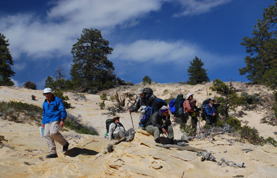
© Roger A. Jenkins, Suzanne A. McDonald, 2008, 2016. Photo of hikers climbing in sand © William H. Skelton, 2008; Photo of Cottonwood Butte with hikers in foreground © Ronald E. Shrieves, 2008