Who Needs Patagonia?
Wind Rivers: Big Sandy to East Fork Valley
Dad's Lake
Monday, September 10 We awoke to clear skies and heavy frost. I kicked myself for having forgotten the ice scraper for the windshield. I need to put a note in my Outlook calendar: on Labor Day, put the ice scraper in the Highlander!! Fueling up for breakfast with coffee from the gas station across the street, we were out of Pinedale before 8 am. The description of the route from Pinedale to the Big Sandy trailhead in the Falcon Press guide is generally accurate in terms of directions, but is horribly inaccurate in terms of total mileage. If one carefully reconstructs the route description given in the Hiking Wyoming's Wind River Range, by Ron Adkinson, it would suggest that it is 40 miles of gravel road (after the paved road) from south of Pinedale to Big Sandy. In reality, it is 26 miles of gravel. Figure 90 minutes from "downtown" Pinedale. You might be able to shave 10 - 15 minutes off that, depending how much rattling your teeth and vehicle can tolerate.
 There were probably "only" two
dozen vehicles at the trailhead when we arrived. My understanding is
that, for the Big Sandy entrance, such is pretty light. The popularity
of the trailhead is driven, in part, by its proximity to the Cirque of
the Towers. Many backpackers can get to the Cirque on a days hike from
Big Sandy. But we had been to the Cirque
in 1997 (we have also been to Titcomb Basin, Bonneville Basin,
Stough Creek Lakes Basin, Ice Lakes Basin, among others.) On this
backpack, our goal was different: a leisurely two day walk to the
vicinity of Pyramid Peak, layover so that we could see the upper East
Fork Valley, and then to a bit of off-maintained trail, taking a day
to come down the lower East Fork to Poston Meadows and then out the
next morning. Five days of relaxing and getting into the Zen of just
being there.
There were probably "only" two
dozen vehicles at the trailhead when we arrived. My understanding is
that, for the Big Sandy entrance, such is pretty light. The popularity
of the trailhead is driven, in part, by its proximity to the Cirque of
the Towers. Many backpackers can get to the Cirque on a days hike from
Big Sandy. But we had been to the Cirque
in 1997 (we have also been to Titcomb Basin, Bonneville Basin,
Stough Creek Lakes Basin, Ice Lakes Basin, among others.) On this
backpack, our goal was different: a leisurely two day walk to the
vicinity of Pyramid Peak, layover so that we could see the upper East
Fork Valley, and then to a bit of off-maintained trail, taking a day
to come down the lower East Fork to Poston Meadows and then out the
next morning. Five days of relaxing and getting into the Zen of just
being there.
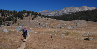
 We were packed up, and hoisted
packs by 9:38 and left the parking lot behind. Our first task was to
find the actual trailhead, since there are several routes out of Big
Sandy. Trail names change with time, and it was not clear if we were
starting on the Fremont Trail, the Meeks Lake trail, or what have you.
Basically, we were headed for Dad's Lake for this evening's camp, and
we discovered that the trail left from the north end of the parking
loop. The morning was sunny but cool. We were well rested and so we
hiked fairly deliberately, as the trail climbed through broken woods
and meadows toward Fish Creek Park. Susie tends to hike fairly
determinedly in the mornings. She is fundamentally a morning person,
even more so than me, and likes to get as many miles under her boots
as practical before lunch. This is a very politically correct way of
saying she is "driven" and it can be hard to convince her to stop for
lactic-acid-buildup-mandated hourly rest breaks. Thank goodness for
climbs, as it a) slows her down and b) generates even more internal
heat, which translates to her having to stop to strip off layers. We
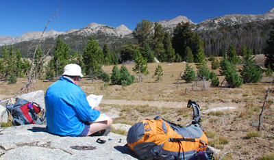
did a brief packs-off break to put away our windshirts in mid morning,
but really did not stop until we arrived for lunch at the south end of
Fish Creek Park. Ok, maybe the over look for Fish Creek Park. I could
tell that Susie was a bit nervous, only tentatively agreeing to stop
and eat lunch, since it was "only" 11:50 am, not yet having reached
the official, approved lunch time of "past noon." Some things never
change.
We were packed up, and hoisted
packs by 9:38 and left the parking lot behind. Our first task was to
find the actual trailhead, since there are several routes out of Big
Sandy. Trail names change with time, and it was not clear if we were
starting on the Fremont Trail, the Meeks Lake trail, or what have you.
Basically, we were headed for Dad's Lake for this evening's camp, and
we discovered that the trail left from the north end of the parking
loop. The morning was sunny but cool. We were well rested and so we
hiked fairly deliberately, as the trail climbed through broken woods
and meadows toward Fish Creek Park. Susie tends to hike fairly
determinedly in the mornings. She is fundamentally a morning person,
even more so than me, and likes to get as many miles under her boots
as practical before lunch. This is a very politically correct way of
saying she is "driven" and it can be hard to convince her to stop for
lactic-acid-buildup-mandated hourly rest breaks. Thank goodness for
climbs, as it a) slows her down and b) generates even more internal
heat, which translates to her having to stop to strip off layers. We
did a brief packs-off break to put away our windshirts in mid morning,
but really did not stop until we arrived for lunch at the south end of
Fish Creek Park. Ok, maybe the over look for Fish Creek Park. I could
tell that Susie was a bit nervous, only tentatively agreeing to stop
and eat lunch, since it was "only" 11:50 am, not yet having reached
the official, approved lunch time of "past noon." Some things never
change.
A note to readers: sometimes it is easier to follow along when one is looking at a map. If you click on this, you should be able to launch a new browser window and open a small map of the route that was taken.
 We had seen four elk as we had
entered the open country on the south end of the park, but lost them
in the woods on the east edge of the open area. The view of the peaks
in the distance added a nice visual accompaniment to lunch, and it
offered a fine place to ponder life. We started hiking again, and
noted a lone figure standing on the trail, on the north side of the
Park. As we approached, the figure began to approach us. It was a
young woman, who was hiking the Continental Divide trail. She was a 31
year old freelance editor who reminded me of a shorter Sarah Boomer. She had been hiking the CDT north
to south, and was considering bagging it for the rest of the season,
as "the nights were getting colder." She indicated that the CDT
through Montana had seemed brutally hot (see comments above in the
Introduction about July's weather) and unending. It is true: the
Continental Divide winds all over western Montana. To follow it must
be, for the thru-hiker, an exercise in frustration. She was pretty
articulate, and seemed to me to be a big fan of lightweight
backpacking. (Note that I am a fan of lightweight backpacking myself,
except that I have not been able to figure out a way to backpack and
be comfortable and safe in a wide variety of backpacking conditions
while carrying a 30 pound pack (the 30 pounds including a week's worth
of food). It occurred to me that maybe there are no such things as
nights that are "too cold." Rather, there are things such as
inadequate sleeping bags and clothing.
We had seen four elk as we had
entered the open country on the south end of the park, but lost them
in the woods on the east edge of the open area. The view of the peaks
in the distance added a nice visual accompaniment to lunch, and it
offered a fine place to ponder life. We started hiking again, and
noted a lone figure standing on the trail, on the north side of the
Park. As we approached, the figure began to approach us. It was a
young woman, who was hiking the Continental Divide trail. She was a 31
year old freelance editor who reminded me of a shorter Sarah Boomer. She had been hiking the CDT north
to south, and was considering bagging it for the rest of the season,
as "the nights were getting colder." She indicated that the CDT
through Montana had seemed brutally hot (see comments above in the
Introduction about July's weather) and unending. It is true: the
Continental Divide winds all over western Montana. To follow it must
be, for the thru-hiker, an exercise in frustration. She was pretty
articulate, and seemed to me to be a big fan of lightweight
backpacking. (Note that I am a fan of lightweight backpacking myself,
except that I have not been able to figure out a way to backpack and
be comfortable and safe in a wide variety of backpacking conditions
while carrying a 30 pound pack (the 30 pounds including a week's worth
of food). It occurred to me that maybe there are no such things as
nights that are "too cold." Rather, there are things such as
inadequate sleeping bags and clothing.
 We must have talked to the young
woman for a half hour. She was interesting, articulate and
enthusiastic. But ultimately, it was time to head in separate
directions. I could tell that standing in one spot was getting to
Susie. But I admit to reflecting on what was in store for her if she
did not quit soon for the season. I have hiked part of the CDT in the
Mount Zirkel Wilderness in Colorado, and on a few chunks of the Trail
in the Weminuche Wilderness in southwestern Colorado in 1999
and 2005. It seemed to me
that the Divide in the Weminuche, in early October, would not be as
much fun as it sounds. Ok, "brutal" is a word that comes to mind.
We must have talked to the young
woman for a half hour. She was interesting, articulate and
enthusiastic. But ultimately, it was time to head in separate
directions. I could tell that standing in one spot was getting to
Susie. But I admit to reflecting on what was in store for her if she
did not quit soon for the season. I have hiked part of the CDT in the
Mount Zirkel Wilderness in Colorado, and on a few chunks of the Trail
in the Weminuche Wilderness in southwestern Colorado in 1999
and 2005. It seemed to me
that the Divide in the Weminuche, in early October, would not be as
much fun as it sounds. Ok, "brutal" is a word that comes to mind.
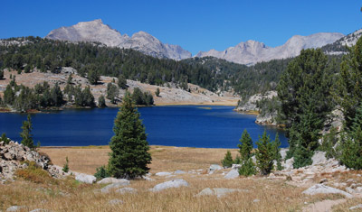
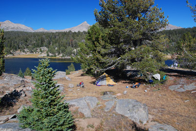
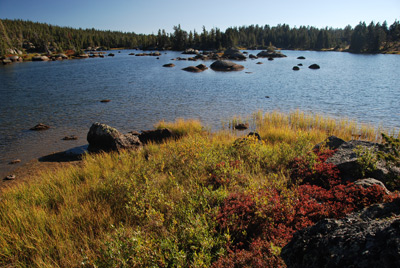 We arrived at the south end of
Dad's Lake (do a search on Google Earth for Dad's Lake, WY and it will
take you there) at 2 pm, and endured yet another example of why it is
always a good idea to pull out the map before one goes exploring. We
thought (without pulling out the map) that we might be able to
circumnavigate the south end of Dad's Lake and find a good campsite on
the western shore of the Lake pretty easily. Of course, any person
reading this and actually looking at a map or a satellite photo might
realize that this could amount to sheer folly.. Yes, there are a few
good campsites. However, the south end of the lake is pretty
convoluted, and while I am convinced that one can get to the west
shore following this route, at some point, one has to consider energy
expenditure, not mere distance, when one is making hiking route
decisions. So Susie and I mentally kicked ourselves, backtracked to
the trail, and headed around the east side of Dad's lake. We found a
place to rock hop the inlet stream, avoiding wet feet, and started
working our way down the west side of the lake. What we found was well
worth the effort: a campsite (12T, 639914 E, 4735341 N - note that all
the waypoints given in the write-up are in the NAD27 coordinate grid,
so they are compatible with those who still use the paper USGS quads)
with a perfectly flat place to set up a tent, a bit of shelter, lots
of granite, and superb views. Life was looking very good. Susie and I
went down to the lake shore and found a good spot to clean up. The
afternoon light was getting even better and we decided to spend a
little bit of time photographing. I was taken by the similarity of the
rockier parts of the lakeshore to what I have seen in Maine. Of
course, in the latter state, there are no rocky peaks reaching 10,000
feet and above......
We arrived at the south end of
Dad's Lake (do a search on Google Earth for Dad's Lake, WY and it will
take you there) at 2 pm, and endured yet another example of why it is
always a good idea to pull out the map before one goes exploring. We
thought (without pulling out the map) that we might be able to
circumnavigate the south end of Dad's Lake and find a good campsite on
the western shore of the Lake pretty easily. Of course, any person
reading this and actually looking at a map or a satellite photo might
realize that this could amount to sheer folly.. Yes, there are a few
good campsites. However, the south end of the lake is pretty
convoluted, and while I am convinced that one can get to the west
shore following this route, at some point, one has to consider energy
expenditure, not mere distance, when one is making hiking route
decisions. So Susie and I mentally kicked ourselves, backtracked to
the trail, and headed around the east side of Dad's lake. We found a
place to rock hop the inlet stream, avoiding wet feet, and started
working our way down the west side of the lake. What we found was well
worth the effort: a campsite (12T, 639914 E, 4735341 N - note that all
the waypoints given in the write-up are in the NAD27 coordinate grid,
so they are compatible with those who still use the paper USGS quads)
with a perfectly flat place to set up a tent, a bit of shelter, lots
of granite, and superb views. Life was looking very good. Susie and I
went down to the lake shore and found a good spot to clean up. The
afternoon light was getting even better and we decided to spend a
little bit of time photographing. I was taken by the similarity of the
rockier parts of the lakeshore to what I have seen in Maine. Of
course, in the latter state, there are no rocky peaks reaching 10,000
feet and above......
 Susie located a great spot to
hang our food, and I managed to get the food hanging cord over the
intended branch on the very first try. We laughed hard, because such
success is very rare, in my experience, anyway. So then it was time to
focus on dinner: one of my favorites - Hamburger Helper Beef
Stroganoff with freeze dried beef and extra dried mushrooms (ok, maybe
the dried mushrooms we add are not "extra" since I am not sure I have
ever seen any dried mushrooms in the unadorned mix.) We had a great
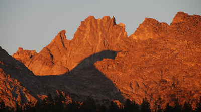
view from camp, but decided to clean up the dishes and head over to
our rocky shelf where we could watch the alpen glow on the peaks to
the east. As we were watching the lake surface, a bald eagle flew by
and settled into a perch across the lake. The alpenglow got deeper and
we just sat there and drank it all in. What a great way to start a
backpack.
Susie located a great spot to
hang our food, and I managed to get the food hanging cord over the
intended branch on the very first try. We laughed hard, because such
success is very rare, in my experience, anyway. So then it was time to
focus on dinner: one of my favorites - Hamburger Helper Beef
Stroganoff with freeze dried beef and extra dried mushrooms (ok, maybe
the dried mushrooms we add are not "extra" since I am not sure I have
ever seen any dried mushrooms in the unadorned mix.) We had a great
view from camp, but decided to clean up the dishes and head over to
our rocky shelf where we could watch the alpen glow on the peaks to
the east. As we were watching the lake surface, a bald eagle flew by
and settled into a perch across the lake. The alpenglow got deeper and
we just sat there and drank it all in. What a great way to start a
backpack.
To view supplemental photos of this trip, go to our TwoHikers SmugMug gallery.
© Roger A. Jenkins, Suzanne A. McDonald, 2007, 2008, 2016