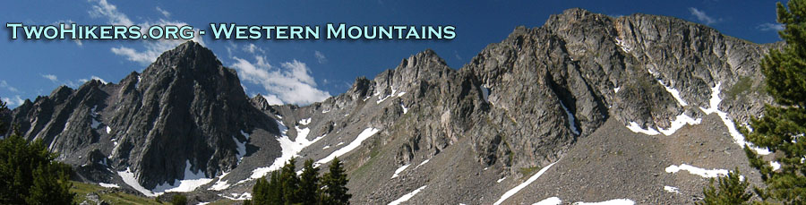
Who Needs Patagonia?
Wind Rivers: Big Sandy to East Fork Valley
Strolling to Maes Lake
Tuesday, September 11
 This trip had been billed as an
easy, relaxing, "touristifying" backpack in the Winds, and neither of
us were in any hurry to undo that approach. We slept in until 7 am,
and crawled out to another cloudless morning. Frosty (27 degrees), but
cloudless. Of course, we had brilliantly located our campsite on the
west side of Dad's Lake, so we could catch the early sunlight. We
congratulated ourselves when the sun hit our camp at 7:30. Susie and I
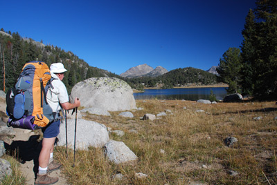
pulled out of camp at 9:20 am, and headed for Marm's Lake. We first
had to negotiate a marshy area on the north end of Dad's, and it took
a bit to actually get to the official trail, but get there we did,
chewing up the better part of an hour on the short climb to Marm's
Lake. There are definitely campsites on the west side of the lake
(near where the trail goes), and a nice one on the NE corner of the
lake, but nothing like we had enjoyed at Dad's. We climbed around the
head of Marm's, leaving the Fremont Trail and climbed gently up a
drainage on the NE end of Marm's. We stopped most of the way up the
climb for a rest break at 10:30 and enjoyed the cool, sunny morning.
This trip had been billed as an
easy, relaxing, "touristifying" backpack in the Winds, and neither of
us were in any hurry to undo that approach. We slept in until 7 am,
and crawled out to another cloudless morning. Frosty (27 degrees), but
cloudless. Of course, we had brilliantly located our campsite on the
west side of Dad's Lake, so we could catch the early sunlight. We
congratulated ourselves when the sun hit our camp at 7:30. Susie and I
pulled out of camp at 9:20 am, and headed for Marm's Lake. We first
had to negotiate a marshy area on the north end of Dad's, and it took
a bit to actually get to the official trail, but get there we did,
chewing up the better part of an hour on the short climb to Marm's
Lake. There are definitely campsites on the west side of the lake
(near where the trail goes), and a nice one on the NE corner of the
lake, but nothing like we had enjoyed at Dad's. We climbed around the
head of Marm's, leaving the Fremont Trail and climbed gently up a
drainage on the NE end of Marm's. We stopped most of the way up the
climb for a rest break at 10:30 and enjoyed the cool, sunny morning.
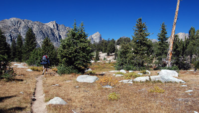
 As we got to what one might
consider to be the head of this little drainage on the Haley Pass
trail, we were greeted by a delightful little plateau. It had super
views in nearly all directions and was dotted with small tarns. The
distant views of the mountains surrounding the valley into which we
would be hiking were getting better and better, and just made us want
to pick up the pace. The Haley Pass trail descends to an easy (at this
time of year, but maybe more challenging in early August) crossing of
Washakie Creek, which made for lots of pretty pictures. (Just before
the trail drops to the crossing, the Shadow Lake trail takes off for,
not surprisingly, Shadow Lake.) After crossing Washakie Creek, we
decided to get a few hundred feet of climbing behind us before we
stopped for lunch. Both of us hate to eat lunch, and start climbing
right away. So we topped out about 300 feet above Washakie Creek,
where the trail begins its descent into the Skull Lake area. We had
been stopped only a few minutes, when a fellow climbed up from Skull
and stopped to chat. He said he was from Chicago and we offered our
apologies. He and his wife were camping over on Skull Lake and seemed
to be having a great time. He took off and we packed up and started
our circumlocution of Skull Lake, saying hi to his wife for him. We
got around Skull - certainly a nice place to camp - and began our
final climb of the day, about 120 feet to an overlook of Maes Lake.
As we got to what one might
consider to be the head of this little drainage on the Haley Pass
trail, we were greeted by a delightful little plateau. It had super
views in nearly all directions and was dotted with small tarns. The
distant views of the mountains surrounding the valley into which we
would be hiking were getting better and better, and just made us want
to pick up the pace. The Haley Pass trail descends to an easy (at this
time of year, but maybe more challenging in early August) crossing of
Washakie Creek, which made for lots of pretty pictures. (Just before
the trail drops to the crossing, the Shadow Lake trail takes off for,
not surprisingly, Shadow Lake.) After crossing Washakie Creek, we
decided to get a few hundred feet of climbing behind us before we
stopped for lunch. Both of us hate to eat lunch, and start climbing
right away. So we topped out about 300 feet above Washakie Creek,
where the trail begins its descent into the Skull Lake area. We had
been stopped only a few minutes, when a fellow climbed up from Skull
and stopped to chat. He said he was from Chicago and we offered our
apologies. He and his wife were camping over on Skull Lake and seemed
to be having a great time. He took off and we packed up and started
our circumlocution of Skull Lake, saying hi to his wife for him. We
got around Skull - certainly a nice place to camp - and began our
final climb of the day, about 120 feet to an overlook of Maes Lake.
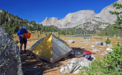
 We would later identify several
campsites around Maes, but it was cool (49 degrees) and the breeze had
become more significant. We found a tree with a large pet rock that
would offer both shade and shelter from the prevailing wind, and
called it home. OK, it was only 1:30, but remember, this was supposed
to be a relaxing trip. We set up our tent near 12T, 639119 E, 4742606
N. Susie wanted to wash her hair while there was still sun, so we
opted for moving bath time up, and finding a semi-sheltered spot along
the outlet stream for cleaning our bods, after which Susie could relax
and read in the tent out of the "breeze."
We would later identify several
campsites around Maes, but it was cool (49 degrees) and the breeze had
become more significant. We found a tree with a large pet rock that
would offer both shade and shelter from the prevailing wind, and
called it home. OK, it was only 1:30, but remember, this was supposed
to be a relaxing trip. We set up our tent near 12T, 639119 E, 4742606
N. Susie wanted to wash her hair while there was still sun, so we
opted for moving bath time up, and finding a semi-sheltered spot along
the outlet stream for cleaning our bods, after which Susie could relax
and read in the tent out of the "breeze."
 I decided that a bit of
exploration of our immediate vicinity was in order. Our original plan
for exiting the area the day after tomorrow (based on cross-country
routes shown on the Earthwalk Press maps of the southern Wind Rivers),
had been to hike up to Pyramid Lake, and take a SW-trending off-trail
route SW and then south for about a mile, to the floor of the East
Fork Valley. The downside of this tactic was that it would require
hiking out of our way, back up to Pyramid Lake. However, on my
exploration, I found a path that starts down a short draw (12T, 639069
E, 4742484 N) that runs nearly perpendicular to the outlet stream of
Maes Lake (the draw being hard to discern on a topo map). Maybe 50
meters down this drainage, there was a path taking off to the left,
which roughing paralleled the outlet creek while descending to it. I
cut left on the path, and started to descend, and confirmed that this
is the way we would want to go the day after tomorrow. So I climbed
back up to camp and told Susie about my find. This would likely save
us two miles on Thursday. Obviously, I was not the first one to have
this flash of brilliance, but it seems like a good idea at the time.
It would prove to be an even better idea.
I decided that a bit of
exploration of our immediate vicinity was in order. Our original plan
for exiting the area the day after tomorrow (based on cross-country
routes shown on the Earthwalk Press maps of the southern Wind Rivers),
had been to hike up to Pyramid Lake, and take a SW-trending off-trail
route SW and then south for about a mile, to the floor of the East
Fork Valley. The downside of this tactic was that it would require
hiking out of our way, back up to Pyramid Lake. However, on my
exploration, I found a path that starts down a short draw (12T, 639069
E, 4742484 N) that runs nearly perpendicular to the outlet stream of
Maes Lake (the draw being hard to discern on a topo map). Maybe 50
meters down this drainage, there was a path taking off to the left,
which roughing paralleled the outlet creek while descending to it. I
cut left on the path, and started to descend, and confirmed that this
is the way we would want to go the day after tomorrow. So I climbed
back up to camp and told Susie about my find. This would likely save
us two miles on Thursday. Obviously, I was not the first one to have
this flash of brilliance, but it seems like a good idea at the time.
It would prove to be an even better idea.
Susie had enough of relaxing in the tent by the time I got back, and given the temp and the breeze, bugs were really not much of a problem. So it seemed like time for dinner. Tonight was our homemade version of Santa Fe Chicken and Rice and Beans. A delightful Mexican concoction: tasty and filling. After dinner, we sat outside, in anticipation of more alpenglow, but no such luck tonight. We would have to "settle for" the spectacular granite peaks rising above the north end of the Lake. Life can be really rough sometimes.
To view supplemental photos of this trip, go to our TwoHikers SmugMug gallery.
© Roger A. Jenkins, Suzanne A. McDonald, 2007, 2008, 2016