Who Needs Patagonia?
Wind Rivers: Big Sandy to East Fork Valley
Out
Friday, September 14 We were up at first light, but it still took us until 8:19 to get out of camp. Nevertheless, I think both of us had Bison Burgers and to-die-for onion rings at the Corral Bar south of Big Sky, MT on our minds as we started moving. We still had to cross one of the two branches of the East Fork (the one of the east side of Poston Meadow) and decided it made more sense to find an auspicious rock hoppable spot just downstream of camp, rather than work out way back to the west side of the meadow to the official trail. We did find a good spot and though it required doing a bit of climbing to avoid being forced back down into the creek, it was relatively easy going. We were headed for Boulder Lake, and so cut to the SE as we climbed away from the meadow. We noted two things: first, the official stream crossing would have been a lot wetter than the spot we had found, and second, there is in fact a nice, group size campsite at the SE corner of the meadow, just off the trail. The climb out of the East Fork valley is steep, but short. Once we made that climb, we were rolling.
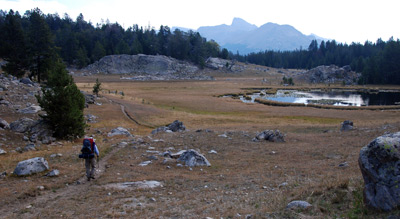 We congratulated ourselves on
our sound (OK, lucky is a better word) decision not to camp at Boulder
Lake. It is really a reservoir and the level was down considerably. In
addition, there are few level spots around it. The term "eyesore" is a
bit too strong, but it is no beauty spot, either. At the southernmost
corner of the Lake (sort of SW), there is a trail junction. If one is
heading, as were we, for the Big Sandy trailhead, you want to take the
left fork, even though it might not "feel" right. The desired trail
heads southeast through small meadows and open woods, continually, but
gently climbing a few hundred feet. About 2.3 miles from Poston
Meadows, it runs thru a nice flat area, along the north side of the
northernmost of Twin Lakes. There are some nice views to the east
toward the high country.
We congratulated ourselves on
our sound (OK, lucky is a better word) decision not to camp at Boulder
Lake. It is really a reservoir and the level was down considerably. In
addition, there are few level spots around it. The term "eyesore" is a
bit too strong, but it is no beauty spot, either. At the southernmost
corner of the Lake (sort of SW), there is a trail junction. If one is
heading, as were we, for the Big Sandy trailhead, you want to take the
left fork, even though it might not "feel" right. The desired trail
heads southeast through small meadows and open woods, continually, but
gently climbing a few hundred feet. About 2.3 miles from Poston
Meadows, it runs thru a nice flat area, along the north side of the
northernmost of Twin Lakes. There are some nice views to the east
toward the high country.
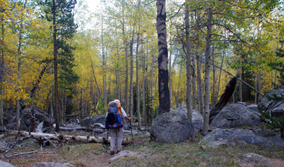 In another half mile or so,
southeast of Twin Lakes, the trail reaches a local high point and
begins its descent. The woods shifted back and forth between groves of
golden aspen and evergreens. Not a bad way to be wrapping up a hike.
About a mile past the high spot, we came to another trail junction,
this one coming down from Meeks Lake and Iron Creek Meadows. We turned
south, since heading back to Meeks Lake would take us way out of the
way. We were following our planned route, but we knew things might get
a tad tricky soon. About a half mile south of the aforementioned trail
junction, we came to another junction at 12T, 641174 E, 4727401 N. I
sorta felt like we were getting into a maze of trails, and was best to
get out the GPS, just to make things easy. We turned left, and
followed a strong trail to the east. This skirted the north side of
the meadow that is to the northeast of Mud Lake. (Note, the map also
shows a trail going along the south side of the meadow, but they join
on the east side of the meadow at a trail that leads one over a small
rise and down into the general vicinity of the Big Sandy trailhead.)
Actually, we came out on a small road that leads out onto the Big
Sandy access road and requires walking back about 250 meters. Although
I did not write it down, I recall getting back to the vehicle at
around 11 am, so we had covered the five miles or so from camp in a
bit less than 3 hours. Nothing like bison burgers and onion rings to
motivate a hiker. After all, who needs Patagonia??
In another half mile or so,
southeast of Twin Lakes, the trail reaches a local high point and
begins its descent. The woods shifted back and forth between groves of
golden aspen and evergreens. Not a bad way to be wrapping up a hike.
About a mile past the high spot, we came to another trail junction,
this one coming down from Meeks Lake and Iron Creek Meadows. We turned
south, since heading back to Meeks Lake would take us way out of the
way. We were following our planned route, but we knew things might get
a tad tricky soon. About a half mile south of the aforementioned trail
junction, we came to another junction at 12T, 641174 E, 4727401 N. I
sorta felt like we were getting into a maze of trails, and was best to
get out the GPS, just to make things easy. We turned left, and
followed a strong trail to the east. This skirted the north side of
the meadow that is to the northeast of Mud Lake. (Note, the map also
shows a trail going along the south side of the meadow, but they join
on the east side of the meadow at a trail that leads one over a small
rise and down into the general vicinity of the Big Sandy trailhead.)
Actually, we came out on a small road that leads out onto the Big
Sandy access road and requires walking back about 250 meters. Although
I did not write it down, I recall getting back to the vehicle at
around 11 am, so we had covered the five miles or so from camp in a
bit less than 3 hours. Nothing like bison burgers and onion rings to
motivate a hiker. After all, who needs Patagonia??
To view supplemental photos of this trip, go to our TwoHikers SmugMug gallery.
© Roger A. Jenkins, Suzanne A. McDonald, 2007, 2008, 2016