Who Needs Patagonia?
Wind Rivers: Big Sandy to East Fork Valley
Down the East Fork
Thursday, September 13
 We awoke to more blue skies, a
bit tempered with a bit of smoky haze and the smell of smoke, and a
relatively mild temperature of 40 degrees. We packed up our gear and
were moseying out of camp at 9:13. We picked up the small path that I
had found the first afternoon, which sorta parallels the outlet creek
of Maes Lake, immediately to the east, and above it. The path is more
like a critter trail that descends pretty steeply, dropping about 300
feet before its confluence with the East Fork River. As soon as we
made it to a slightly less steep spot, we crossed over the outlet
creek, in stages, and climbed over a slight rise to get to the river.
We awoke to more blue skies, a
bit tempered with a bit of smoky haze and the smell of smoke, and a
relatively mild temperature of 40 degrees. We packed up our gear and
were moseying out of camp at 9:13. We picked up the small path that I
had found the first afternoon, which sorta parallels the outlet creek
of Maes Lake, immediately to the east, and above it. The path is more
like a critter trail that descends pretty steeply, dropping about 300
feet before its confluence with the East Fork River. As soon as we
made it to a slightly less steep spot, we crossed over the outlet
creek, in stages, and climbed over a slight rise to get to the river.
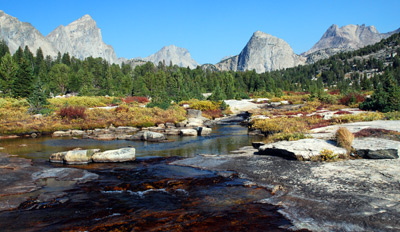
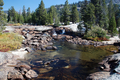
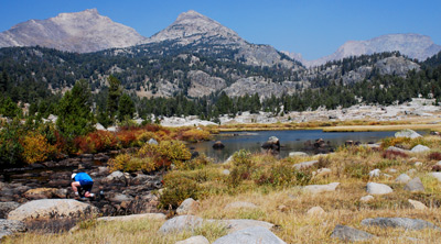
Oh brother. Another spectacularly beautiful spot. The river cascades over a series of broad rock shelves. The banks are lined with evergreens and the peaks of the East Fork Valley rise about the entire scene. Did I mention that much of the lower vegetation was turning gold as autumn arrived with an air of inevitability. We spent a fair amount of time taking lots of photos of the scene, attempting, but falling short, to capture its beauty. But go see for yourself: the spot is around 12T, 638545 E, 4742045 N.
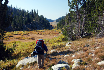 We reluctantly turned away, and
headed downstream, following the general XC route marked on the
Earthwalk Press map. The going was easy, which was good, because we
were feeling in a lazy mood. In some places, there was a discernable
path, and in others, it was like a few deer had walked through the
spot last year. But still, easy to follow, since we were just
following the drainage downstream. About a mile and a half downstream
of the aforementioned beauty spot, we ran into a young woman who was
horse packing for a NOLS group. The group was headed to the highest
lake in East Fork Drainage. I imagined that tent sites would be pretty
spartan in that area, simply because of a very low grass to rock
ratio.
We reluctantly turned away, and
headed downstream, following the general XC route marked on the
Earthwalk Press map. The going was easy, which was good, because we
were feeling in a lazy mood. In some places, there was a discernable
path, and in others, it was like a few deer had walked through the
spot last year. But still, easy to follow, since we were just
following the drainage downstream. About a mile and a half downstream
of the aforementioned beauty spot, we ran into a young woman who was
horse packing for a NOLS group. The group was headed to the highest
lake in East Fork Drainage. I imagined that tent sites would be pretty
spartan in that area, simply because of a very low grass to rock
ratio.
 We encountered the NOLS group
about the same time that we encountered our first "official" trail of
the day, to the west of where Washakie Creek flows into the East Fork.
The trail crosses our route perpendicularly, but we noted that there
were no trail signs (perhaps because there was no official trail
coming down the route we had earlier. However, this point is where the
maintained trail down the East Fork valley begins and you would think
there would be a trail sign. (In fact, we would encounter no trail
signs whatsoever until the Chillcoot Trail leaves the East Fork Trail
probably three miles down the valley.) But we were clearly on the
maintained trail: the trail swerves to the east and crosses the East
Fork on a huge sheep bridge (We GUESSED it is for sheep. It is
certainly overkill for humans.) We crossed the bridge and hiked a few
hundred meters more before stopping for lunch, and pumping water,
sometime shortly after Noon.
We encountered the NOLS group
about the same time that we encountered our first "official" trail of
the day, to the west of where Washakie Creek flows into the East Fork.
The trail crosses our route perpendicularly, but we noted that there
were no trail signs (perhaps because there was no official trail
coming down the route we had earlier. However, this point is where the
maintained trail down the East Fork valley begins and you would think
there would be a trail sign. (In fact, we would encounter no trail
signs whatsoever until the Chillcoot Trail leaves the East Fork Trail
probably three miles down the valley.) But we were clearly on the
maintained trail: the trail swerves to the east and crosses the East
Fork on a huge sheep bridge (We GUESSED it is for sheep. It is
certainly overkill for humans.) We crossed the bridge and hiked a few
hundred meters more before stopping for lunch, and pumping water,
sometime shortly after Noon.
 After lunch, we continued on the
East Fork Trail, heading downstream. We had decided to make a slight
shift in plans. Originally, we had planned to stop for the night at
Boulder Lake. However, looking at the map, we noticed that such would
be outside the official Wilderness area, so had modified our goal to
attempt to stay somewhere near the north end of Poston Meadows. So we
were not in a big hurry, again, in keeping with the overall
"atmosphere" of the trip. A short mile after our lunch stop, the trail
began a short climb through scattered timber to avoid dropping into
the same gorge that the east fork pours thru. A quick look at the
gorge shows why the trail builders elected to stay out of it. It is
not deep, but it is very rugged. The bypass drops into yet more
meadows (thankfully dry by this time of year), and skirts them to the
east. Near 12T, 637500 E, 4735918 N, the topo map shows the trail
crossing to the west side of the river, and joining the Highline Trail
coming down the west side. Well, it is one of those occasions to pick
your spot, since there is no bridge. The crossing does not appear to
be very deep, but it is not clear how deep it MIGHT be earlier in the
season. Rock hopping in mid-September was no problem.
After lunch, we continued on the
East Fork Trail, heading downstream. We had decided to make a slight
shift in plans. Originally, we had planned to stop for the night at
Boulder Lake. However, looking at the map, we noticed that such would
be outside the official Wilderness area, so had modified our goal to
attempt to stay somewhere near the north end of Poston Meadows. So we
were not in a big hurry, again, in keeping with the overall
"atmosphere" of the trip. A short mile after our lunch stop, the trail
began a short climb through scattered timber to avoid dropping into
the same gorge that the east fork pours thru. A quick look at the
gorge shows why the trail builders elected to stay out of it. It is
not deep, but it is very rugged. The bypass drops into yet more
meadows (thankfully dry by this time of year), and skirts them to the
east. Near 12T, 637500 E, 4735918 N, the topo map shows the trail
crossing to the west side of the river, and joining the Highline Trail
coming down the west side. Well, it is one of those occasions to pick
your spot, since there is no bridge. The crossing does not appear to
be very deep, but it is not clear how deep it MIGHT be earlier in the
season. Rock hopping in mid-September was no problem.
The trail continued to head south, dropping through a gentle narrow valley and arrives at a signed junction with the Chillcoot Trail, near a small lake. We decided a rest stop was in order and I commented that I could see the first cloud of the entire trip. It was 2:10 pm. That is a lot of cloudless hours for the Wind River Mountains. After a small snack, we hoisted for our final pull of the day. As we dropped into the head of Poston Meadows, we noted the Wilderness sign, which seemed to us to be premature. Indeed, the sign was a good half mile north of the point where the trail would cross the boundary as marked on the map. We looked around the western edge of the meadows and while there were camping spots, it looked like we could do better. We checked out the meadow itself, but had no interest in being THAT out in the open. We ultimately found a small spot, previously used, tucked in close to some trees at the northeast corner of the meadow, near 12T, 637772 E, 4732832 E. It was probably 3:30 pm by the time we selected our campsite. An abundance of riches, I guess.
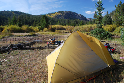 Actually, it turned out to be a
pretty good spot. The creek/river was not flowing too hard at this
point, and it ran past the site thru a canopy of trees and shrubs
which reminded us of fall on the Cumberland Plateau in Tennessee. We
cleaned up and I measured the air temperature in the shade: it was 58
degrees, the highest of the trip, so far. Dinner was penne pasta with
pesto sauce and pre-toasted pine nuts and lots of parmesan cheese. Ah,
for a nice buttery Chardonney…. We had cooked in amongst the trees,
just to provide some shelter from the breeze, and decided to build a
small trash fire with a few sticks of "driftwood." We did this right
on the bank of the stream so that we could have some shelter and to
make it easy to clean the fire spot afterward. We chatted and
determined that an early breaking of camp in the morning would suit
our needs to have dinner at one of our favorite watering holes, and
streamline the trip home. Avoiding late season tourists in Yellowstone
was also a priority. So we tried to make camp as shipshape as possible
BEFORE retiring to the tent. Theoretically, this is meant to
streamline the camp-breaking process, but I am not sure as to its
efficacy with Susie and me.
Actually, it turned out to be a
pretty good spot. The creek/river was not flowing too hard at this
point, and it ran past the site thru a canopy of trees and shrubs
which reminded us of fall on the Cumberland Plateau in Tennessee. We
cleaned up and I measured the air temperature in the shade: it was 58
degrees, the highest of the trip, so far. Dinner was penne pasta with
pesto sauce and pre-toasted pine nuts and lots of parmesan cheese. Ah,
for a nice buttery Chardonney…. We had cooked in amongst the trees,
just to provide some shelter from the breeze, and decided to build a
small trash fire with a few sticks of "driftwood." We did this right
on the bank of the stream so that we could have some shelter and to
make it easy to clean the fire spot afterward. We chatted and
determined that an early breaking of camp in the morning would suit
our needs to have dinner at one of our favorite watering holes, and
streamline the trip home. Avoiding late season tourists in Yellowstone
was also a priority. So we tried to make camp as shipshape as possible
BEFORE retiring to the tent. Theoretically, this is meant to
streamline the camp-breaking process, but I am not sure as to its
efficacy with Susie and me.
To view supplemental photos of this trip, go to our TwoHikers SmugMug gallery.
© Roger A. Jenkins, Suzanne A. McDonald, 2007, 2008, 2016