
Bowdie Gypsum 2004
Frustration in SE Utah
Down to Fable Valley
Sunday, May 9
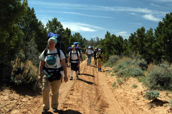 After a modest continental breakfast at the Four Corners Inn, we were packed and rolling by 7:30 am. This is one of those cases when you have to "do the math." You figure out when is the latest you want to get to the area in which you plan to camp, and start back-calculating, and leave yourself some pad. That said, 7:30 was about the earliest I figured I could blast this crew out of town, and with the change in driving route, resulting from what was, in retrospect, some poor information from the Forest Service, I figured we needed to leave as soon as practical. My original plan was to drive north of Blanding on a Forest Service road, and then head west along the south slopes of the Abajo Mountains toward Elk Ridge, cut north just a tad and head west out North Long Point to the head of Fable Canyon, or as close as the road would take us. Well, a call to the Forest Service earlier in the week had raised the possibility that "the road from Monticello to Blanding is typically closed until June, due to snow." A later call from the BLM indicated that the best way to get to Elk Ridge was to take the dirt road through the Bears Ears. This latter route figured on adding at least 45 minutes to the trip, but we had plenty of time padding, so I figured we would be fine. To say that the route from Natural Bridges to the Fable Trail head is tediously slow is an understatement. Probably, it is about 2 hours and 45 minutes of driving. The scenery is nice (great overview of upper Arch Canyon) and exciting (the trip across The Notch -a narrow spine between the heads of Dark and Notch Canyons - requires that one pay a LOT of attention to one's driving). The route off of North Long Point, to the Sweet Alice Hills, is breathtaking - literally.
 But eventually, we got to the Fable Valley Trail head, or what I thought was the trail head. Actually it is, and there is a register box to prove it, but if you have a high clearance vehicle, you can get maybe another 100 meters or so down the 4WD road to a car park with a small modicum of shade. At this point, I got into an "animated discussion" with Will. He had the National Geographic Trails Illustrated map of the Dark Canyon Plateau, which showed the "real trail head" being perhaps a mile and a half down the 4WD road. Will said: "I thought we were going to the trail head down there." I countered with: "Well, I provided maps to everyone, and they all show the trail head up here. If you had bothered to look at them you would see that the trail starts here, since we are already past the register box." (Both of us can get pretty tactless sometimes. Obviously.) Will would later agree, after hiking down a 4WD road that I would not wish on any vehicle I owned, that National Geographic needs to do a few "ground truth" surveys.
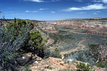
Lunch was in the desiccating but cool breeze, after which we did final loading, we left the cars about 11:30 am. Indeed, the 4WD road on which you hike is pretty rough. Heavily eroded and steep and rocky. After something like 2.25 miles, the trail goes into a corral. (On the northern end of the corral area, there are good overviews of Upper Fable Valley.) This provided a bit of discussion and route finding, as Ron thought that we were someplace else. Fortunately the GPS was receiving plenty of satellites, and it did not take a lot of work to convince folks that the trail had to be on the east side of the corral. It is at this point that the trail dives toward the floor of Fable Valley, losing something like 450 feet in the next quarter-mile. There is a trail, and we pitied the poor cattle that had been forced to descend it. As we approached the floor of Fable, we could see a few folks climbing around in some overhangs across from us. 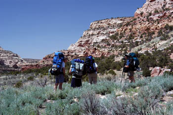 These were approximately near 12S 590660 E, 4193680 N (note that all UTM coordinates in this report are given in NAD27 coordinates). The potential ruin sites (I felt sure that there was something up in there, since Kelsey had marked them as such) were fairly high, and I didn't want to spend the energy climbing up, so we headed on (Ray would eventually report that these folks were from Arkansas, and would be the only folks we would see in the backcountry for our entire trip.).
We began to look for water in the stream bed, cut deeply into an arroyo, about 30 or 40 feet below the main canyon floor. Following one of the many trails, we dipped down to cross the arroyo, and immediately ran into water. Admittedly, this was some of the most unappetizing water I had ever seen. The entire area smelled like a barnyard, and the water was brown. I could not determine if the color was due to stagnation, or just represented diluted cattle excrement. We had plenty of water with us, having started with two liters each. Susie and I climbed back to the main floor, and found several folks waiting under some trees as the path passed a point on the south side of a small drainage. It did not take much effort to locate some spectacular ruins on the west wall of the canyon. It was not clear how to get to them, but in the meantime, Sue had found a ground level ruin on the north side of the side drainage. Her interpretation was that such was where the Anasazi lived before they were forced up on to the cliff walls by raiders. If you looked hard, you could see some old rock walls.
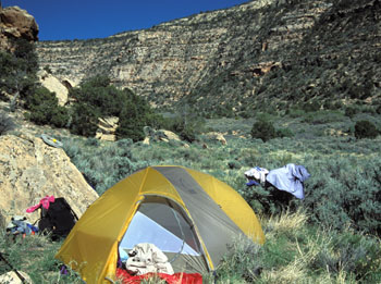 We decided to leave the cliff ruin exploration for our return trip up the canyon, and move on to Fable Spring. The walking was pretty smooth, and one could motor at a couple of miles per hour. Within 45 minutes of swift hiking, we arrived at Fable Spring at about 3 pm. What a welcome sight after what Ray called the "cow piss" upstream. I don't think I have ever seen a spring running so hard in the dessert, and I have seen some great springs. Imagine maybe three garden hoses just gushing down the side of the hill. Cold, clean water. Ok, there is, like always, a hitch. It is tough to get to. You have to go steeply downhill and then fight your way back up. But it is cold and clear and delicious and makes up for its lack of easy accessibility. We sat around the spring for a bit and chatted with our compatriots. Susie and I looked around, and decided that camping at this spot (south side of the "creek" bed) was marginal at best. So we descended into the obligatory arroyo, crossed the thicket of vegetation irrigated by the spring, and hauled our way up the steep northern bank. Our thought was to find a bit of shade from the afternoon sun, and some flat tent sites. What we found was better than near the spring - slightly. If you tucked yourself up near the rocks, you could find a bit of shade. Susie and I set up our tent, and went back to the spring to get water and bathe. We chose the spot where the trail crosses the outlet flow of the spring, and it was marginal at best. Susie fought with the brush to try to carve out a spot where she could stand, whereas I merely tolerated the inconvenience. I could see her mood deteriorate by the moment. It was hot, and there was little shade. And the no-see-ums were incessant, to say the least. Since the tent was out in the sun, there was no where she could escape the bugs without roasting. Not a pleasant choice.
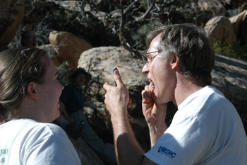
The afternoon's entertainment was watching Lance try to get cactus spines out of his mouth. He was trying to show his kids, Cliff and Cora, how one could eat a prickly pear catcus if one was careful. The wild thing was that after he got one spine in his mouth, and figured out how to get it out, he ate some more cactus flesh, and got two more spines in. I think several of us were ready to nominate him for a Darwin award that day.
 Dinner was our Mexican Surprise (a mix of tomato soup with enchilada sauce mix in it, ground beef, poured over chili and cheese Fritos, and of course, I got demerits for having fixed too much food in the heat (I could have eaten it all, but then I would have been criticized for eating too much. It was just one of those nights.) Because of the lack of shade, most of us had all tucked our tents up near a rock face. That limited the privacy, and maximized the cacophony of snoring throughout the night. Combined with the fact that our new tent (Sierra Designs Hyperlight AST) was not on a level spot and was light but required asymmetrical sleeping layout, and Susie is the kind of person that longs for symmetry ..... well, as I said, it was one of those nights.
© Roger A. Jenkins, 2004; Campsite photo © Suzanne A. McDonald, 2004