
Bowdie Gypsum 2004
Frustration in SE Utah
Beaten by Bowdie
Friday, May 14
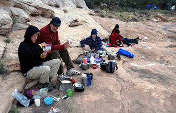 It was a pleasantly cool evening, and most of us prepared breakfast swathed in heavy PolarTec. Will had gone out making yet another attempt to locate the wayward rope. He had been carrying it with him during his many attempts to find a route into the South Fork from the north side of canyon. He laid it down for a bit, and simply could not find it again when he went to look for it. He felt really badly, but no one could accuse him of not trying to find it. He knew that not having the rope might limit our ability to get into the North Fork and I think that such was one reason he was looking for it so diligently. But sometimes, extreme diligence does not count for much. So we departed camp a few minutes after 9 am, ropeless, and took about an hour or so to get back to the split. But the discussion was still not over. Will wanted to follow the route that I had interpreted from Kelsey's map. However, I had put in that route prior to reading the description of a route from the Canyoneering book that covers this area. In such, there is a mention of how the canyon (North Fork) "ends" at 6005 feet elevation. "Ends" sounded too much like a major pour off for me to be comfortable with coming in above it. So we decided to put some waypoints near the spots where we thought the Canyoneering 2 book illustrated an exit route, and headed off to find those spots.
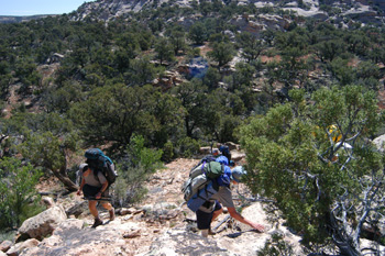 As we rounded the escarpment to our west, I recall making a mental note that, in the future, prior to covering truly unfamiliar territory, I should not rely on a preconceived mental image of how the terrain should look, but rather look at it on Google Earth, so I could get a more realistic image in my mind. The terrain to our west looked from a topo map merely to be a rounded rise. But when you get there and look at it, escarpment is the word that comes to mind. We spent about 90 minutes carefully working our way to the north, targeting a spot on the canyon rim just downstream of the point labeled 6005T on the map. When we got there, it was clear to me that we had done the right thing. Susie immediately pointed out a huge pour-off (well, you could not actually see the pouroff itself, but you could look upstream and see the canyon floor, and you could look downstream and see the canyon floor, and figure that in between, there had to be a huge elevation loss). The challenge of route finding in this country was highlighted by Will's initial insistence that the canyon we were looking at was a side canyon of the main North Fork of Bowdie. I got a bit frustrated because it seemed hard for Will to believe the GPS. In my usual tactful manner, I yelled at him: "Goddam it, Will, I took a fuckin' waypoint at the spot we are standing, and we are 300 meters west-northwest of the spot labeled 6005T. I KNOW where we are, and we ARE NOT lookin' at a goddam side canyon." My frustration and shortness of temper were rising with the temperature.
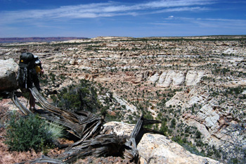 We could look down to the north, and see delightfully large pools of water in the bottom of Bowdie, but it was not apparent as to how to get there. Sue and Cliff took off, and tried to find a spot that went down to the bottom about 200 - 300 meters to the NW of where we were resting in the shade. Both of them disappeared for a long time, and reappeared a few hundred feet below us. I could see them working back toward our direction, where there seemed to be a promising band of rock that might enable descent. But then we saw them shake their heads and turn around, and I knew things were not looking good. When they returned after 45 minutes, we all did an assessment of our water situation. Most of us only had a liter or so left, and we knew at the rate that the low humidity was wicking the water from our bodies that our remaining time would be short. We decided to make one last push, and move to the spot where the Canyoneering book showed an exit route. I was not optimistic, but felt like we had to keep trying. The crew moved out to the NNW around the edge of the escarpment about another 20 minutes, until we came to a spot near 12S, 582148E, 4199000 N. About 150 meters to the north was to be the spot where the Canyoneering description indicated an exit route. John and I dropped our packs and went out to look, but there was just nothing that looked sufficiently promising to warrant a go-for-broke descent attempt. We knew that Cora's knee was giving her fits (why she had decided to push on for the second canyon was not clear, but then we all make decisions based on different values), we were close to being out of water, and I think psychologically, we were beaten. Time to live to fight another day.
 At about 1:35 pm, we hoisted, and began something of a forced march back to the split. We spent very little time on route finding, since we could follow our footprints. We wanted to lessen the time that we would remain outside and have become even more thirsty. In about 90 minutes, we got back to "the split", and rested for maybe 20 minutes in the shade. We still had about 3 miles to go. Not a huge uphill climb, to be sure, but in our discouraged mood, anything was more than we wanted to hike. We pushed along at about 2.4 miles per hour, according to my GPS. Susie and I finally passed Cora and Barbara, who was keeping Cora company. As we started the last half-mile or so, the rockiness of the road eased a bit, and here came Lance, hiking toward us with a big water bag. He had decided that everyone could use a good long drink, so he had dropped his pack, jogged back to the vehicles, picked up water we had stored there, and walked back down the 4WD road we were on, filling hikers' water bottles along the way. Boy, the fresh water felt good. Really picked up my spirits, as I quit musing about the frustration of not getting into Bowdie, and started focusing on what we would do with a couple of "found" days.
We arrived at the vehicles at about 4:45 pm, ready to sit on cushiony seats. It seemed that after the days of frustration on this backpack, folks were ready for a bit of urban enjoyment. Well, at least as "urban" as SE Utah gets. We crammed into our remaining three vehicles (Ray had taken John's 4WD the day before) and headed for Blanding. (A parenthetical comment here: it requires a vastly shorter amount of time to go on the "causeway" dirt and gravel road between the Fable Valley trail head and Blanding, compared with route that uses Highway 95 west from Blanding to Natural Bridges, then up through the Bears Ears, etc. 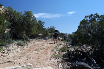 On the latter, we had spent 3 hrs 20 minutes, whereas the former required 2 hrs 25 minutes back to Blanding. The Forest Service person who told us the road was closed from Monticello to Blanding was probably correct, but such is really irrelevant. The "closed" part of the road was over a high mountain pass, which you would not cross if you were headed to Fable Valley from Blanding. She was simply "geographically challenged." I guess not everyone is a "map person." Either route offers wonderful scenery, so it was nice to get both routes under our belts.) Diane had a cell phone with her, and as we moved toward the east and got to some high points, she was able to get service and call the Four Corners Inn. I am sure they were happy to rent another six rooms for the night, and we were happy to be there. It was nice to be able to find our way out of the canyons - for once.
© Roger A. Jenkins, 2004