
Bowdie Gypsum 2004
Frustration in SE Utah
Retreat from the Abyss
Monday, May 10
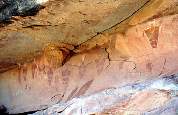
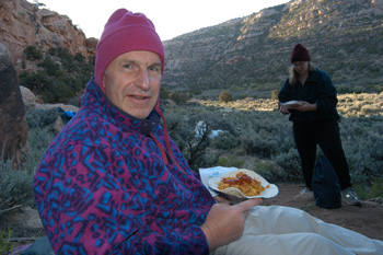 Thankfully, the temperature had cooled nicely during the night (46 degrees). Susie's spirits picked up with the dawn, and the prospect of a great breakfast. We were up a little after 6 am, and fixed a breakfast burrito, using freeze dried Mexican Omelet mix and stuffed it into a flour tortilla with re-hydrated picante sauce. Absolutely wonderful. (As it turned out, I would need a good breakfast.) We took a rather leisurely approach to breaking camp and due to the complex breakfast (ok, complex relative to instant oatmeal and coffee), and the need to inspect a really first rate panel of pictographs just a hundred meters from our campsite, it took us until 8:50 am to roll. We were scheduled for a big day.
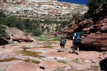
I would not want to say that upper Fable Valley is boring. It just does not seem like a canyon. The walls are 300 - 400 meters apart, the bottom is flat, and while there are nice ruins (including some neat ones on rock pinacles in the middle of the canyon floor - obviously used as sentinel spots), I think that the bottom is so wide that you have the feeling of hiking in a wide field, rather than a narrow canyon. So after an hour plus of really motoring down canyon (something like 2 and a quarter miles covered), the narrowing of the canyon and the crossing of a rock slab on the canyon floor, with real, not-completely-cow-piss water cascading over a rock shelf was sufficient cause to stop, relax and take in the scenery. My left foot was feeling a little sore, so I loaded up with Vitamin I, and relaxed in the sunshine. We frogged around sufficiently that we did not pull out until 9:40. Still nice and early, but it was clear it was going to be a long day.
 After hiking another mile plus, we knew that we would have to start picking up the "official" stock trail that heads over the Beef Basin. It is that trail which provides a safe route around the impending pour-off at the north end of Fable Valley, and takes one to the point where you can begin the descent into Gypsum Canyon. Naturally, with this herd of cats, everyone had a slightly different idea as to the potentially best route for picking up the trail. Some of went up on the east bank early, some of us went up the gully, but we all seemed to be unsuccessful at finding the spot where the trail left the stream bed. Most of us had climbed a steep hillside, maybe 50 - 70 feet above the canyon floor. However, Susie, efficient person that she is, had decided to stay in the stream bed, and yelled up to us that she would scout the route further on. Sue offered to join her, and so our two Susans scouted while the rest of us sat on our butts - in the shade of course. The day was warming up. They were gone maybe 20 minutes or so and yelled up that a) they had found the exact spot where the trail leaves the stream bed (this was not a particularly difficult task, since there was a nice big cairn at the appropriate point) and b) we should take a good look at what was coming up. While it might not be the mother of all pour-offs, it was certainly the biggest one that any of us had seen since the one we had found in the tributary of Road Canyon in 1996 that had to be at least 150 feet high.
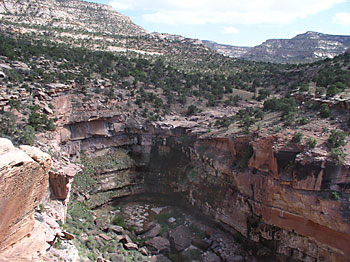
 We all hustled down to the stream bed, and it was just a few minutes before we came to the cairn that leads up the east bench and begins the ascent around the pour off. And what a pour off it is. Although water had been flowing in the stream bed until the last 500 meters or so, there was no water flowing over the dry fall - just seeming through seams below the surface. From what we could tell, it was a veritable garden at the bottom, but no one wanted to get close enough on the sloping bench to take a really good look. So Kelsey's directions were perfect at this point: go to the pouroff, and find the trail up on the right. The trail goes into another side canyon maybe 200 - 300 meters before you lose sufficient elevation to cross the floor, mildly climbs back up and we stopped for lunch just on the north side of the point marked 6114. By this time, we were beginning to get a sense of the challenge here: we could start to view the lower recesses of Gypsum, and could see that it would be a long way down.
At this point, Ray said to me: "You know, given how my hip is hurting, I don't think I can make it to the bottom, stay there just a day, and climb out the next day, with a long hike after that, since I can see that it will be a very steep descent. I think I am going to pull a George on you." (Referring to the time that George turned around in Snake Gulch in 1990. It had just been too soon after his first bypass surgery, and he had just not built up his conditioning.) I was not surprised, since I had seen how slow Ray was hiking. Having hiked with him for over 25 years, I know that he can stand a lot of pain, so it must have been awful. He said he was going to mosey on back to Fable Spring (Ray is a great believer in high quality water) and wait for us to come up canyon in a couple of days. I hated to see him turn around, but it must have hurt him more.
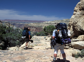
 So without our historical route finder, we metaphorically saddled up, and headed for the big descent that we knew was waiting for us just around the corner. And true to Kelsey's instruction, as soon as you pass through the old barbed wire fence and brush pile (the fence is in ruin, so some of us, including yours truly, passed right through the choke point without noticing the old fence), you look to your left, find a cairn, and can head down at your leisure. Yeah, right. Actually, you stand there, looking at the first drop, which requires lowering packs, and say Oh Shit!! According to careful measurements on the topo maps, the elevation loss is 950 feet in abut 1100 horizontal feet. Yeah, I know that it is not even a 45 degree slope, but given how rocky things were, we could see this would be a sufficient challenge. Now Kelsey indicates one "route finds" over benches to the northeast, and then makes a 180 degree turn to the left, and walks down a gully and finally a rock slide. We stood at the top of the first pitch and looked, but it was not clear where to pick up this gully. There are is some flatter terrain about 250 meters to the northeast of the initial descent point, so lanky Lance (who crawls around rock like a guy in his 20's) took off to do a bit of scouting. Sue went off to see if there was an easier way down, further to the east. Well, Lance reported that it does get easier after maybe a hundred feet of elevation loss but that he could find little sign of footprints, and there was no obvious gully (from his vantage point). Sue reported back that it only got worse, the further east one went.
 At this point, I am not sure who first suggested an "Itinerary Adjustment", but it was clear that a) we were burning lots of time we did not have trying to find a route down b) a very steep descent - if we could find the route - that would be tough to do with packs and c) we would have to repeat the fun after a "day off" by climbing out on Wednesday. Susie first said she was getting decreasingly comfortable with doing the descent with full packs, and I think the tide definitely turned when Sue, who is pretty game for lots of rock scrambling, came back from her explorations to the east, looked hard at the descent, and said "Holy Shit!" So it was time to discuss our options. The clear winner was, in retrospect, pretty obvious: We head back upstream, find a nice place to camp for two nights, and do the descent, at least so we could get down into Gypsum, on our "layover" day. In addition to not having to haul big packs down and back up the route into Gypsum, a start further up canyon on Wednesday would permit us to have lots of time to explore all the ruins we had seen on the way down. Will, Diane, and Ron had found a not-too-difficult way up into the really big ruins about 1.3 miles upstream of Fable Spring. In addition, in the approach side canyon, they had found a large pool of non-stagnant water that could support (for a night or two) a group of this size. So at 1:45 pm, we turned around, lamenting Ray's early departure. If he had stayed with us until the descent point, he could have spent the next couple of nights with us. But decisions are decisions, and now, our objective was to find a place to camp.
 The spot where the water stopped flowing over the rocks was high on our list, and we found a pretty good spot with some shade (juniper and pine, not cottonwoods) about 45 minutes back upstream from the descent point. Susie was in near ecstacy because, by wedging in our tent between two trees, the shade would be pretty good throughout the day. We were pretty spread out over the bench located at12S, 588024E, 4200135N. And with a short walk, we could go upstream and not have to fight the brush to clean up. Yeah, we had to treat the water, but I had drunk worse. Dinner was Lipton Broccoli cheddar and rice, and we put some dried salmon in it. Not one of our better dinners, but compared to some of the stuff that was being eaten around the dinner rocks, it was not too bad. The breezed started to pick up, and by 9 pm, it seemed like a great time to crawl in the sack.
© Roger A. Jenkins, 2004; Photo of group nearing the edge of Gypsum © Suzanne A. McDonald, 2004; Photo of pour-off © William H. Skelton, 2004