
Bowdie Gypsum 2004
Frustration in SE Utah
Can't someone find a way?
Thursday, May 13
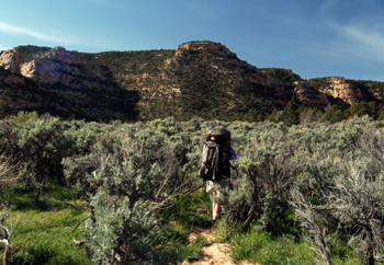 This was to be a big day for us: climb out of Fable Valley, re-supply at the vehicles, move about 5 miles, and then hike down a abandoned 4WD road, eventually descending into one of the forks of Bowdie canyon. We were up early, but it did not do us much good. It was a frosty morning, with an "official" temperature- from Andy's thermometer - of 25 degrees F. We discussed if there had ever been a spring canyon trip as cold as this night, and this might have been close to being a record for us. I got the not-so-brilliant idea to air out our sleeping bags around 6:30 am, and they were promptly covered with frost. Not smart. The underside of our tent fly was pretty much frozen, and it seemed pretty obvious that it would take a while for the sun to arrive. So Susie and I busied ourselves with other camp chores, waiting for the sun. When it finally hit, things dried quickly, and it was nice to look forward to a cool, sunny day of hiking. We were on the trail at 8:32, Ray having left much earlier. The climb, as expected, was nice and steep up the point that leads out of Fable Valley. It took us an hour of hard climbing to get to the "corral." After a brief rest, Susie continuing to remind me that we had a long way to go that day, we pushed on, with the road back up to the vehicles alternating from flat to climbing gently to climbing "briskly." Susie and I arrived at the vehicles at 10:35 am.
Ray beat us back, but he announced that for him, this was the end of the backpacking trip. He had a bad cold, and felt awful. With his hip hurting badly, he saw no point in prolonging his misery. We all felt sorry for him, because we understand that without him doing something radical to his hip joint, his chances of joining us for another long backpack look slim. Meanwhile, we all seemed to take our time getting new supplies and fresh clothing out of our luggage, and stuffing the dirty clothing back in the vehicles. We piled in after the dirty clothes, and headed west on the dirt road another four miles. As we pulled out of the parking area, we encountered the first folks we all had seen in a week. Some old "geezer" was shuttling a couple of trail runners, that were planning to run all the way down and into Fable Valley, past the spot where we descended into Gypsum, and on to Beef Basin. We told them about the water in Fable Spring, and wished them good luck, but we all commented about their lack of preparedness: they were not quite sure if they were at the correct trailhead or not. If you are not sure about such, and are planning to run through unknown terrain, well, it seems to me that you need to have more than a water bottle and some Power Bars with you. Anyway, in about 15 minutes, we pulled into a spot that felt like the middle of a feed lot, there was so much cattle "sign" around. The area was grossly over grazed, and it seems like the BLM just does not care about abuses such as this. Well, maybe in a few more years, I can work harder on such. It took some time for us to all get going, but we finally rolled at 12:35 pm. Yeah, it takes a bit for the old farts, Cora and Cliff excepted, to get moving.
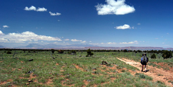 Just like Kelsey says, there is little practical way to move beyond the " wall" that was maybe 200 meters to the west of where we parked. Actually, it is a little 3 foot high shelf that one has to negotiate. On foot, no problem. On 4WD, well, again, I would not want to take anything that I owned over it. The old road bed is a true 4WD road: pretty easy to walk in places, with killer long range views of the Henry's, as it gently slopes down to the spot where we had to make a decision. It was about 3 miles or so from the vehicles, where we all stopped at the obvious split. OK, there is no real split, but it is the point where the road seriously turns to the SW, if you are headed into the South Fork of Bowdie, and where it is time to leave the road if you are headed into the North Fork. Susie and I pulled up where most of our crew was waiting, about an hour and 20 minutes from the vehicles. There, we sat down under the welcome shade of some junipers, and proceeded to discuss the route. The fundamental issue is that you can look at the little tiny dots on the Kelsey map, showing a supposed route into the North Fork of Bowdie, but it is not really clear as to how one translates such to an on-the-ground reality. Will thought we should head off on the route that I had plotted, but as I looked over the terrain, to the extent that I could with all the darn trees blocking my view, I was not so sure. I explained that the route that I had done on the map was my meager attempt to translate Kelsey's dots, but I certainly was not sure that such would get us where we needed to do, especially when I pulled out a copy of the pertinant pages from Steve Allens "Canyoneering 2" and read the route that they described. The item that concerned me was the description of the point where the canyon "ends" in a huge, impassable pour-off, as one heads upstream (near 6005 feet) While Will and I were discussing such in an animated fashion ("arguing" is such a negative term), Susie came up with a really good idea, that seemed to capture the fancy of us all. She said "Look, it really does not make any difference which way we go around this loop: enter the North Fork, enter the South Fork, who cares? The point is that we will see the same terrain, and if it is easier and more direct to get in at the Sorth Fork, let's consider that." Well, after all the "discussion", it took about 10 seconds for the crew to adopt this approach, and only a bit more time before we were hustling down the 4WD road into the head of the South Fork. Essentially, Susie was relying on the age old premise that it is always easier to find your way OUT of a canyon from the bottom, than finding your way IN from the top. The real problems is that when one stands in the high country, all of the subtleties of the route are not obvious. When you are on the canyon floor, all is revealed as one looks up.
So we trudged down the remainder of the 4WD road around 2:15 or so, confident in our ability to find the route in, since Roger had originally determined this to be the exit route on Monday morning. Yeah, in your dreams, Fleishmann!! The 4WD track ends right after it crosses the head of the South Fork. There is supposed to be a spring around there, but we saw no evidence of any water flowing, and this was certainly the time of year that if there WAS going to be water, it would be now. After leaving the track, we dropped into the canyon floor, and began to work our way down around small shelves and ledges. Susie turned around to me and said, "You know, this is really fun!" For a woman who, 20 years ago, derisively referred to my canyon trips as "backpacking in a ditch," she had come a long long way. Canyons have that effect on you.
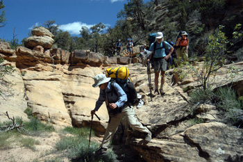 The shelves graduated to true "pour-offs" that required some small bit of negotiating, but we moved along pretty smoothly for 20 minutes or so. Then we came to a 25-footer that would require a bit of scouting. While Sue and Ron were scouting, Susie dropped her back and climbed up on a 50 foot high bench to our left, to take in the big picture. I watched her get to the crest of the rise, take a look around. Then she turned to us and yelled down "Guys; you ought to see what is coming up. We have got a major problem." She indicated that there must be a series of pour-offs, none of which she could really see, over the next 100 - 150 meters of canyon bottom, because just a little bit around the bend, she could see the canyon floor, and it was a helluva lot lower than the floor on which we were standing. In other words, there was no point worrying about this next little pour-off, if we could not get down around the big ones coming up. I decided to climb up on the ridge, to see what Susie was talking about. When I got to the top, the picture was not pretty. She was right: within maybe 100 meters of canyon bottom, the floor dropped considerably. There was no clear way to negotiate the "discontinuities" that I could see. I went back down to where the rest of the crew was waiting, and suggested that it would be critical for folks like Will and Ron and Lance, who seemed to be filled with energy this day, to scout around the next couple of bends in the canyon, in order to find the way down.
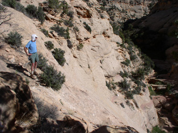
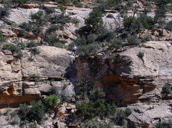 Meanwhile, I climbed back up on the ridge to watch their progress. We yelled instructions and ideas back and forth across the narrow chasm. I stood staring out, down the canyon, and realized that I could see a small band of rock, perhaps 2/3 of the way down, way out a couple of hundred meters downstream from where I was standing. The band was perhaps 25 - 35 feet thick, and framed by rubble fields above and below it. I yelled out to Ron that maybe at the far western end of the band, there might be a crack or something I couldn't see from this vantage point, that would "go." He and Will went out to investigate, (Lance was scouting other routes) but said they did not see anything that would work. So I took off, having to round an indentation at the high level I was at, before descending the rock ledges and rubble fields. Within a few minutes, I got to the spot at which I had been looking, and was overwhelmed by frustration. It was pretty certain I had found the point of descent. However, looking at it, I could see it was beyond the comfort level of most of the folks on the trip, including me. Basically, it was a notch in the rock, but with nothing on which to hold for the first 15 feet of descent. It was not clear to me that there were any footholds. Why could it not be like what we had dealt with on the Gypsum canyon descent??!! I decided to go around the corner, to look up into the tributary that was coming in from the left. More big pouroffs! So back to the crack. I yelled over to Will and Ron that I thought I had found the easiest spot at which to descend, but that it was not easy enough. Will yelled back that there seemed to be little upon which to attach our 50' Goldline rope for a belay. Maybe if we had a longer rope ......... I looked and looked for an easier route, but this was it. We either could try it or not, but this was our only choice.
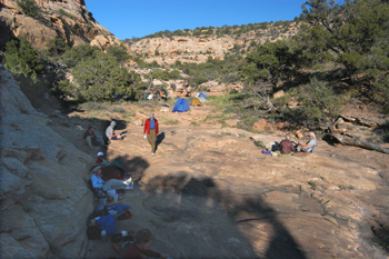
 It seemed like we were beaten for today, but we could have picked worse places to get stuck on a canyon rim. We had several flat spots to pitch tents (some even had a bit of sand, instead of rock, so that tent stakes could penetrate, for those lacking free standing tents) and water. Ok, scuzzy water, in three separate pothole pools. Diane indicated that there was no way that she was going to drink any water that had a dead frog floating in it, no matter how much is was treated. Her rationale was that she had gotten giardia three times when working for the Peace Corps in South America, and it was a pretty unforgettable experience. Being the scientist that I am, I explained how the water purification pumps that many of us were carrying work, but this seemed to be an emotional response that science simply could not overcome. But for the rest of us, there was a pool from which we could dip water to bathe, and one we could get water to drink. After a quick bath and a nice dinner of beef stroganoff, I and some of the rest of us amused ourselves watching Lance do he and his kids' laundry. It turns out that despite the fact that we had re-supplied food at the car, they had made a decision not to plan for a clothing re-supply. Whew, to each his own. But instead of doing like many of us did, which was to wash out clothing each day, the three of them opted to save all dirty laundry for a grand extravaganza. Looked like a pile you might make in front of your washing machine at home. Like I said, to each his own.
 It seemed that the next task around the evening campfire, which was pretty small because there was not a lot of wood and we did not want to scar the rocks, was to decide on what Plan B might be. It was clear we could not exit out the South Fork of Bowdie in this spot, and while it seemed like there was some enthusiasm for bagging the trip right now, and heading out in the morning, most of us felt like it was worth the ole' college try. (One of the challenges in these situations where one has SO MANY independent individuals is acknowledging everyone's separate interests, while maintaining an approach that does not involve scattering the group to the four winds.) So our plan when we hit the sack was to go back a mile or so to the split area, try the off-trail route into the North Fork of Bowdie and see if we could find a way down. If we could get down, we would try to spend maybe three nights down there, understanding that we might have to position ourselves higher in the watershed to get out and back to Albuquerque than we had planned originally. The options rolled around and around in my head as I drifted off to sleep.
© Roger A. Jenkins, 2004; Photos of "The Crux" and Ron on the slickrock © William H. Skelton, 2004