
Bowdie Gypsum 2004
Frustration in SE Utah
The Neil Armstrong approach to hiking
Tuesday, May 11
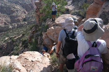 It had been one of those freight train nights, when it feels like you are camped along the tracks. You hear it coming, know it is going to hit, and just hunker down in your bag until it passes. Everyone confessed to feeling like they had gotten only 30 minutes of sleep, though I am convinced it must have been a dozen times that much. Our new Hyperlight AST held up just fine, although I could feel some fine dirt blowing in through the mesh. But at least the tent had not flapped. It was a cloudy morning, and it looked like the clouds were getting thicker. Susie and I were up at 6, but managed to frog around until 8:15 when we left camp with our day packs. With the exception of Cora, who stayed in camp, everyone else seemed to be game for the idea of trying the descent without packs. The difference between backpacks and day packs can mean the difference between hard work and hard exercise. We arrived at the descent point (12S, 588371, 4201169) at 9 am, and decided to do a group scouting effort. The first 20 feet is probably easiest if one turns around and faces into the rocks. After that, it is just steep descents of so-called benches (more like rubble fields). Lance sort of led the way, with Cliff, his son, not far behind. It is not difficult as you head to the northeast, but like the saying goes about real estate, everything is about location. That was our quandary concerning the location of the descent gully. It is not clear from Kelsey's brief description how far to the northeast one goes before one does the 180 degree turn down into the gully.
 When you look out to the northeast, there seems to be an obvious point and a spine of rock, that looks like might lead to a gully, maybe 250 meters from the first descent point. So we headed for that. We got out there, and Will and Lance did a lot of scouting, since the gully seemed steep and might have a pour off about 50 - 75 meters down it. Neither could come up with a clear sense of whether the gully would "go" or not, so Cliff volunteered to scout the gully, and look at the spot in question.
At this point, it is time to talk a bit about Cliff. He should be an inspiration to everyone who says that they are just too old, or infirm, etc, to do this hiking and backpacking stuff. Cliff is a lively 17, has been in Boy Scouts and backpacked with them. He had never been out more than a couple of nights at a time, but his father (the Scoutmaster) reports he can hike with the best of them. He did tell me earlier in the trip that he had gotten fairly tired at the end of the 22 mile day hike he had to do for his hiking merit badge. Gee. Did I mention that Cliff has no right foot, nor a right or left fibula? He was born that way, so he really knows nothing different, but wearing a prosthesis for one's right lower leg and foot has to be classified as some sort of handicap. But to Cliff, it is just something that you deal with. Watching him boulder later in the trip was interesting. I had read about a guy in the New Hampshire mountains that had lost both his feet to frostbite, and had become an incredible rock climber, because his artificial feet never got tired. The old lemons into lemonade approach to life. (Cliff has his own take on life, as you might expect.) Anyway, as Cliff got down closer to the lip that we could not see below, you could see him getting increasingly cautious. I heard him say something, but did not pick it up. Sue indicated to us that "given the fact that Cliff is shinnying up to the lip on his belly, and I heard him say the words ‘absolute catastrophe' should clue us in that this is NOT the route we want to take."
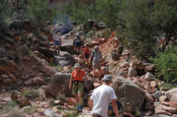
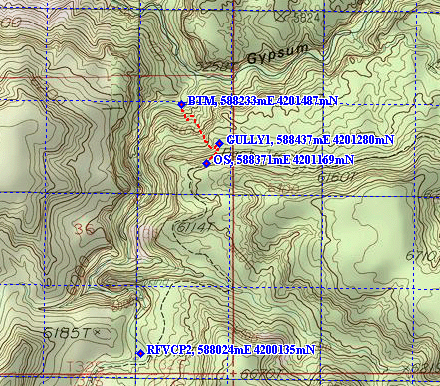
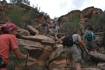
 Everyone was becoming increasingly frustrated, both with the amount of time we were burning scouting the route, but mostly with the our own incompetence at finding the route down. In the jumble of rocks that comprised the ledges, it would be easy to lose a whole series of rock cairns. We talked for a bit about giving up trying to find the route down, and considered heading over on the trail toward Beef Basin. But we could hardly resist giving it one more shot, so we started collectively moving to the west-southwest, and had gotten about 100 meters or so, and our scouts found a cairn on the lip of a gully. The good news was that this was likely the place. The bad news was that it was very very steep. The lip of the gully is at 12S, 588437E, 4201280N. It is closer to the drop down point than we had expected, but then, there is no reason to have expected either a short or long descent prior to arriving at that point.
OK, into the gully. It was about as steep as one could find and still have some of the rocks stable. The way down is very rocky, and most of your effort will be expended remaining upright. The rocks were pretty loose, and the multitudinous calls of "Rock!!" echoed down the canyon. I kept thinking on the way down that a) without a walking stick for balance and to provide a "third" leg, I would have a very difficult time and b) that descending with a full backpack would have been even more fun, since my fanny pack kept brushing against rocks directly behind me. About 2/3 of the way down, we came to a lip around which one can not get unless one can fly. However, by traversing slight up and over to the left (headed down), you get into a second gully, and that seems to go. Admittedly, it is pretty hard to tell the difference between what Kelsey calls a "gully" and a "rock slide." Both are pretty rocky. Anyway, right near the bottom, the grade eases a bit, and the going is less rough. We set foot on the canyon floor about an hour after we started the descent in the gully. Plan on more with a backpack. Interestingly, contrary to what Kelsey implies, you do not arrive at the confluence of lower Fable Valley and Gypsum Canyon. Instead, you are about 150 meters upstream of the confluence, in the final flow of Fable Valley (12S, 588233, 4201487). But you will be very happy to be on solid ground. There is a bit of scrambling to get the actual confluence, but nothing hard at all. (You can click here for the first ever published exact route into Gypsum Canyon from Fable Valley).
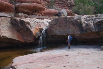
T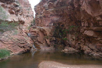 here was good water (at least from a volume standpoint) in both arms of the "confluencing" canyons. We moved just a very short way down Gypsum, and worked our way around the first waterfall. (It is not a pour off, since there is water flowing over it.) It seemed like a wonderful time for lunch. There were big slabs of rock. Clean, nice, and a wonderful place to catch one's breath. After lunch, we went downstream another 50 meters and looked at the next waterfall. Hmmm .... Even from the overlook where you start down into Gypsum, we could see that this fall could be more problematic. It is not high, maybe only 25 feet, but there is no way to directly descend it. So we got out Kelsey's description of how to hike Gypsum from Lake Powell, or what used to be the Lake in this area. Into the fifth year of the Southwestern Drought, the Lake is only filled to 42% of capacity, and the upper Lake is mostly mud flats, with the Colorado running through it. Reading that description, it appears that this is the 9th falls. (It fits all the descriptions.) According to Kelsey, to get around this falls, you would have to go back upstream above the falls we just got around, go up something steep enough that you need a rope if you were going up with packs, find the correct cliff level (he admits that there is no trail) and route find until you find a 75 meter long talus slope that may be about 100 meters downstream of the fall that you are trying to get around. Reading all this, and scanning the cliffs and benches on the west side of the canyon, it seemed that this was going to be more like work than fun. (The fact that we had to climb back up the gully we had just descended probably contributed to this attitude.) So we decided that we would spend some time heading up Gypsum, keeping in mind that the climb back up was still ahead, as well as the trip back to camp. We figured on allowing 2.5 hours from the time we would start back up, until arrival back at camp, so our time in Gypsum would be limited. (I admit that where we were discussing all this, I felt just a tad like Neil Armstrong must have felt on the first lunar landing: All this effort to set foot here, and I only get to spend a couple of hours.)
 We headed upstream through occasionally dense vegetation in Gypsum, perhaps 500 - 600 meters, when we came to a lovely grotto and water slide. Lance worked his way into it, which I imagine we all could have done if we had needed to. But the weather was clouding up, and threatening rain, so we decided that this would make a good turn around point. We walked back to the gully floor, pumped some water, took a hard look at the gathering clouds, and started our ascent. Truth be told, it was not as hard as we had expected. Well, it took us a while to figure out the traverse to the next gully about 1/3 the way up (it always looks different when you go back), and it is easy, as Cliff did, if you are watching the rocks immediately in front of your face (like they are most of the way up when you are standing) to get a bit off track, but we were at the top of the gully after a 45 minute climb. (We had gotten hit by rain about half way up, but not as hard as we would have been had we stayed at the confluence a bit longer. We could see the shower really pounding that area.) We stood at the lip, prided ourselves in having done at least something right, and headed for the descent slot. Of course, even though the distance between the gully lip and the slot is only a hundred meters or so, it is rock city on a slope (about 300 feet of elevation gain in 100 meters) and things are not obvious at all. It took us maybe 20 minutes to do the 100 meters, with Susie doing most of the route finding. As I said, it ain't obvious. (I would definitely recommend that if you have a GPS, you pre-program in these waypoints ahead of time and use them. Route finding on these slopes is a challenge.)
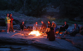 A 45 minute walk brought us back to camp. While I sorta staggered around back in camp, Susie packed up all our bathing gear and we headed off to clean up. Sue had noted that there seemed to be a bit less water in the creek bed, but it was hard for me to tell. Susie and I bathed and did a bit of laundry, thinking that the day after tomorrow, we would be back to our food/fresh clothing cache in the vehicles. We cleaned up, and threw the water up on the stream bank, and got ready for dinner. Tonight, we all headed for the rock shelves a bit further upstream from camp. That way, we sit in a semi-circle and actually look at each other. Those that wanted shade could get it, and those that wanted sun could get that too. Life was good. Susie and I fixed Lemon Pepper Penne with dried smoked turkey. Only thing missing was a good bottle of Sauvignon Blanc. Must have left that back in the Excursion. Yeah, in my dreams. Since we were all in a pretty relaxed mood, facing an easy day tomorrow, a nice campfire seemed to be in order. We gathered wood, which was about as difficult as breathing, and found a sandy spot on the rocks in the stream bed to build the fire to lessen the impact. It was a classic campfire, and we all stayed up later than we would have otherwise. It was a good feeling.
© Roger A. Jenkins, 2004