
Lower Grand Gulch 2003
Shifting to Plan B
Trailhead to the perfect camp
Sunday, April 13
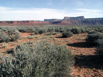 Without our resident late sleeper, Will, on this trip, it seemed that most of us were ready pretty darn early. I think we were all in need of a canyon trip, AND we knew it would not be short hiking day. Normally, we get started mid-afternoon, and just hike in a couple of miles. But this time, the ability to get started early today would enable us to get within striking distance of the San Juan River with two full hiking days. We rolled out of Blanding at 7:35 am, 10 minutes ahead of schedule. As we went through the cut in Comb Ridge on Utah 95, you could practically feel Ron's jaw drop. As this was my 23rd trip to canyon country, it is easy to get a bit passe about the scenery on the way to the trail head, but I never completely lose the thrill of seeing it all over again. We were heartened to see water in some of the stream beds. However, no gully washers were in sight. When we pulled into the parking lot of the Kane Gulch Ranger station, we felt like we were at Grand Central Cedar Mesa. There were not really any long term spaces left in the lot. Twenty years ago, the place would have been deserted, in part because twenty years ago, the BLM did not require one to pick up one's day hiking or backpacking permit in person at the station, and pay for it. So in a way, the crowd was a bit artificial. However, that there were this many people out hiking is a tribute to the beauty of the canyons carved into the Mesa.
As I picked up our permit, I chatted with the volunteers. I offered to provide them with a copy of our itinerary, but they did not really want that. So much for the adage about always leaving a trip plan with a ranger. All the volunteers wanted from us (since I had already provided my credit card) was a water report for LGG. Seems that while they had an idea that the water in the upper part of GG was pretty much pools, they had no recent information about the water in LGG. So even though they did not care where we were going, I promised them a water report. Little did they know that rangers who behave badly can find themselves being called to task on TwoHikers.org. I did mention to them that the last time I had been in LGG (18 years previously), the water spanned the stream bed all the way to the river. The volunteer acknowledged that yeah, she had heard stories about the 1980's.
The road into Collins seems to get rougher each time I take it. This time, the last couple of miles were slow, unless you were riding with ex-Marine Ray. He likes to drive everything as though he is running the 24 hours at Le Mans (Even a ride in a Honda Accord over Chilhowee Mountain can be a harrowing experience if done at "Ray Speed.") He did slow down when the bed rock is exposed, only to hit the accelerator when he got back on dirt. He can be a good driver, and we never have any real problems, but he is the kind that feels the need for speed. Maybe the seat over the rear wheels adds an extra dimension to it all, but I was glad when we arrived at the trail head, and could pull my heart back out of my vocal chords.
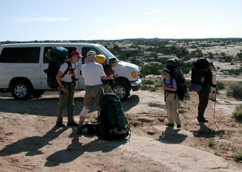 We pulled into the Collins Canyon trail head about 9:15, getting the next-to-last easy (not balanced on a rocky ledge) parking space. I guess the week before Easter is a popular time. There was another small group that pulled in right after us: a couple from Idaho and a guy from Maryland. They seemed to be heading in the same direction (down LGG) as we were, and I sensed that they were a bit unhappy that a group as big as ours (although we were substantially smaller than in past years) would be sharing the canyon with them. There was, as always, the usual frogging around at the trail head. I am as guilty as the next person: despite the fact that my hiking boots were already on, and it should have been a simple matter of moving my camera lenses from their travel-to-the-trail head position to their quick access hiking position, it STILL took me - and the others - nearly a half hour to be ready to hike. So we started dropping off the lip of the canyon - which is more of a simple draw at this point - at 9:44. A few minutes after we started, I could tell we had a convert in Ron. True, it was a lovely Canyon Country day: clear blue sky, still cool, birds chirping, and the fragrance of warming sagebrush drifting up the canyon. At the rate Ron was shooting film, I wondered if he would have sufficient supply to last him to the second day of the trip.
 The route down Collins Canyon is pretty much of a cake walk: just follow the draw, and at places where it might otherwise have been difficult, stock trails have been blasted to make it easier for horses and cows to get in. The BLM still allows pack animals into Grand Gulch: talk about impact!! We have even expressed displeasure to our own Sierra Club National Outings program
about their use of animals to carry gear in such fragile places. To me, it is simply way too much impact, both in pounds per square inch on the ground and pounds per day of fecal matter deposited, often right in the stream bed, to justify their use. The response has been pretty underwhelming: this gives the chance for people who might not otherwise go on such trips to fall in love with the terrain and be willing to fight harder to protect it. That may be true, but the narrow canyons are particularly fragile environments: the canyon bottoms are often very narrow, and unlike most mountainous regions, there is little area in which to disperse the impact. All that said, we continue to rejoice that the BLM has made some of the right decisions: the cows are now gone. It is interesting to see the remarkable changes that have occurred in just the last few years. The differences between the conditions of the canyon benches in the early and mid-1980's and today blow you away. I sometimes feel like what I should be doing is carefully retake photos I took 20 years ago, as such would help convince people of the problems associated with government subsidies of grazing cattle on public lands, especially those as fragile as these.
The route down Collins Canyon is pretty much of a cake walk: just follow the draw, and at places where it might otherwise have been difficult, stock trails have been blasted to make it easier for horses and cows to get in. The BLM still allows pack animals into Grand Gulch: talk about impact!! We have even expressed displeasure to our own Sierra Club National Outings program
about their use of animals to carry gear in such fragile places. To me, it is simply way too much impact, both in pounds per square inch on the ground and pounds per day of fecal matter deposited, often right in the stream bed, to justify their use. The response has been pretty underwhelming: this gives the chance for people who might not otherwise go on such trips to fall in love with the terrain and be willing to fight harder to protect it. That may be true, but the narrow canyons are particularly fragile environments: the canyon bottoms are often very narrow, and unlike most mountainous regions, there is little area in which to disperse the impact. All that said, we continue to rejoice that the BLM has made some of the right decisions: the cows are now gone. It is interesting to see the remarkable changes that have occurred in just the last few years. The differences between the conditions of the canyon benches in the early and mid-1980's and today blow you away. I sometimes feel like what I should be doing is carefully retake photos I took 20 years ago, as such would help convince people of the problems associated with government subsidies of grazing cattle on public lands, especially those as fragile as these.
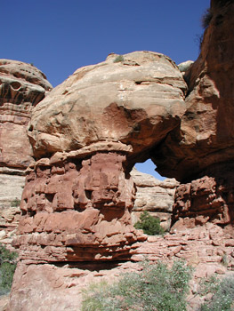
It was heartening to see actual water in the stream bed of Collins. It gave us hope that things would be fine in the main canyon. We stopped for a rest break at a small arch about an hour down the canyon. I had photographed it considerably two years ago from its northwestern face. In trying to put a different "feel" on what was basically a repeat of the first couple of hours of that trip, I tried to photograph it from its southeastern face. We were making pretty good progress, so I felt like we could afford the time. Not that I, as trip planner (using that term very loosely), have any sort of control on a group of seven extremely independent types. Most of us have been hiking together a lot for at least one or two decades. We all pretty much understand each person's style. I can be a tough task master in the day or hours before we get the trail head, but after that, everyone is on their own. My experience has been that on trips like these, our group can be spread out over a stretch of canyon perhaps a couple of kilometers long. This one wants to photograph this flower, another one wants to inspect a ruin, and a third wants go up in a side canyon. Under difficult circumstances, we will tighten up and pull together, but most of the time, it is pretty much a free for all. I think, for example, that there was only one day on the entire trip when we would all eat lunch together.
There seemed to be a bit of er, ah ...... confusion when some of the party arrived at the confluence of Collins and Grand Gulch. Susie was up on some bench (ahead of me, natch), asking whether this was really the Gulch itself. I yelled up and assured her it was. Ray was convinced that it was not the Gulch, period. He said, "Well, if this is Grand Gulch, then where was the side canyon we were supposed to have passed?" My response was something to the effect: right back where it was supposed to be. I assured him that Ron and I had stopped at the side canyon's mouth, and taken photos. I realize that this might sound like the latest version of The Old Farts Go Hiking, but I do admit that over the years, the confluence of the two canyons seems to have changed quite a bit. Just take a look at the confluence on a topo map.
It seems that there are canyons going every which way. In addition, even the topo map is not correct. It shows the stream bed flowing around the Narrows, not through it, which it has clearly done for a long, long time. On the ground, there are some large benches and sand islands that obscure the view, so it can get a little confusing. Ron was willing to go with the flow, and besides, he had darned near burned through a roll of film in the last couple of miles, so he was more interested in the scenery than his maps. Most of the crew moved on, while I stopped and talked a bit to a fellow named Art Johnson. He looked to be semi-retired, was involved with the Sierra Club group in the Dallas Area, and was up in canyon country just poking around, doing backpacks and day hikes for 50 days. Ah, the good life, for sure. He provided me with the locations of a few pictograph panels, a nice kiva ruin, and confirmed that there were good pools of water in the vicinity of Water Canyon. So the report was promising.
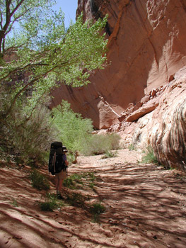
 But the walk through the Narrows was not. In past years, it has always been a deep wade. Even two years ago, well into the Southwestern drought, there was plenty of water to wade through. So as I approached the formation, I was surprised to see a) no Susie putting on her boots on the downstream side, and b) so little water that you could walk right through with dry boots. Hmm, this did not bode well. Susie was way up high on a bench, admitting that she had turned into the rincon (abandoned meander of the streambed), thinking it was the route down canyon. Had these folks replaced the water in their bottles with Jim Beam, or what?? She reported that many of the rest of the crew were up in the rincon, looking at the really superb pictographs that are on the walls. But she had decided that we had seen them just a couple of years ago, so it was time to move on. Another bend in the canyon brought us past the mouth of the canyon that we refer to as the Toilet Bowl. We stopped to pump some water out of a pool and moved closer to the next bend. It was time for lunch, but many of our compatriots were trying to figure a way to get up in a ruin on the south facing slope. I looked the situation over, and decided that lunch was more inviting. Besides, to get up to the ruin, one would have to go back up canyon about 150 meters, and climb up a slickrock slope that, based on the rate of progress of the rest of the crew, was not particularly easy. I tried to ignore Susie's complaints that I was getting lazy. Pleas for conservation of energy fell on deaf ears. The lunch spot was shady, and Ron discussed ways of conserving film. As we were starting to get up, the pull of the ruin was too much, so he headed back up canyon.
Not wanting to be marked as terminally lazy, I volunteered that if we could spot the high up pictographs around the next bend, we should try to go up there, since I don't remember visiting those 18 years ago. I was able to spot them, and we began a search for a safe route up high. We found one, and made to a small panel of hand prints and figures. As the rest of the crew moved past the point, we alerted them to it, and Sue, I think wanting to see every site in the Gulch, headed up without hesitation. Well, we should have saved our energy. If you stay low, there is an enormous panel of hand prints maybe a hundred meters downstream, about at 12S, 574095 Easting, 4140339 Northing. Probably the biggest one I have seen in the Gulch south of the one near Polly's Island. Pretty amazing.
 About 1:45 pm we stopped for a break, having gotten a bit warm on our slickrock excursion. It is easy to forget that even though the air temperature is in the mid-70's, the south facing rock faces can really heat up in the full sun. And any time the air temperature is in the mid-70's, the temperature in the sun is about mid-90's, and that can be a tad warm. Ron, Susie, and I hiked for about another half hour, and then Ron announced that he really needed to eat something, so she and I moved on. (Ron would later report that he had drunk about 1.5 quarts of water that day, feeling pretty proud of himself. He being a canyon novice, we explained that such might be enough to get him through part of a morning at this temperature, and that he needed to be drinking at least 3 - 4 liters between camps. The symptoms he was reporting were perfectly consistent with a bit of dehydration.)
The afternoon was getting to be a trudge. I was in the highly unusual position of being at the front of the pack. When Susie starts to drag, you know it has been a hard day. Probably not so difficult in and of itself, but it was warm, and we had only been in this time zone about 24 hours. Jet lag is always tough. We stopped for a break, and with the GPS, I figured we were only about a kilometer or so above where I had planned to stop for the night, which in turn was about a half mile upstream from the mouth of Water Canyon. I think what made the last kilometer worse was the absence of water. Just dry gravel and rocks in the stream bed. You KNOW you are going to run into it eventually, but I keep running through my mind how far we will have to carry the water, will it be any good, etc, etc. Ron had caught up to us, and seemed to be a bit more chipper. So misery loves company, and we kept on pushing. As I got near the place I felt would be close to where I had put a campsite waypoint, I stopped dead in my tracks. There was a pool of water in the stream bed. I told Ron to go up into some trees and check out a spot for potential camping. Meantime, I thrashed around through the jungle that was the spot that I had planned to camp (green smudge on the topo map) and decided to walk downstream a bit to see if I could find a decent campsite. 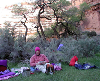 I ran into the couple from Idaho/guy from Maryland that we had met at the trail head. The Idaho guy seemed decidedly short in his responses to my attempts at conversation, as if to get the message across: "Don't even THINK of camping anywhere near here!" I went a bit further downstream and could not find anything appealing so headed back to where I had left Ron and Susie. Hanging tight to the wall on the west side of the canyon, I went through a clump of trees, and here the two of them were, standing in a veritable oasis. Thick grass, some trees to add a bit of shade and some interest, full shade (it was only 4 pm or so) and a huge pictograph panel above us. We had arrived (12S, 573005 E, 4138537 N). We put out a bandana, as the spot was tough to see if you are hiking in the stream bed, and set about putting up camp. We noted that some jerk had built a fire in the last year or so right on a nice patch of grass. Some folks have no class - or common sense. If you must build an illegal fire, for heavens sake, do it where there is essentially no impact, like a sandy spot in the stream bed.
The rest of the troops started filing in, excited to see such a beautiful spot -with flowing water downstream of the pool - to spend two nights. What a great way to start the trip. By 5 pm, Susie and I were so hungry that we started cooking: our version of Santa Fe Chicken and rice. Since Knorr stopped making Rice Mates, we had to come up with our own recipe, but I think it is as good, if not better. Everyone seemed to be pretty tired from the heat and the traveling and hiking. Bed time was not long after dark.
© Roger A. Jenkins, Suzanne A. McDonald, 2003