
Lower Grand Gulch 2003
Shifting to Plan B
To the San Juan
Thursday, April 17
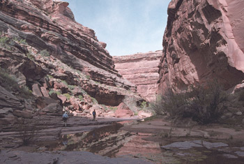 This was our day to get to the San Juan River. Back in 1985, when we had attempted the Lower Grand Gulch/Slickhorn Canyon Loop, it had been a tough, hot haul with our full backpacks down to the river, only to see that the river was in flood stage, and the only possible way to traverse to the mouth of Slickhorn would be to spend the rest of the day in the baking heat and sun on a south facing slope, crossing huge blocks of talus. Not our idea of fun, so we aborted our dreams of a grand tour, and focused on enjoying the canyon we were in. I recall that the hike to the river was not easy, but I was looking forward to giving it a try with a day pack on. Most of us were out of camp by 8:40 or, and planned on taking a couple of hours to get the 2.5 miles down to the pour-off that is the "crux" of getting to the river. About 800 meters below our camp, we came to the spot where the college students had been camping on our first trip (12S, 570416 E, 4131324 N). It is still a nice area, and worth considering if you want to be closer to the river than the mouth of Shangri-La. Below this point, the canyon becomes increasingly spectacular. There are some signs of what must have been gargantuan flash floods. On one huge boulder, there was an ancient cottonwood tree trunk that had been deposited during such an event. Seeing such, and taking a few moments to imagine what it might have been like, and hoping you could have found a way out of the way of this aqueous freight train is a humbling experience. Beyond that point, there were huge slabs of slickrock in the creek bed. OK, trickle bed. Where the algae in the rocks suggest a near-permanent water flow, the amount of water flowing this day could not have been 5% of what we had experienced 18 years ago. There is more than enough water to survive, but even the photographs have a different feel to them.
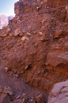
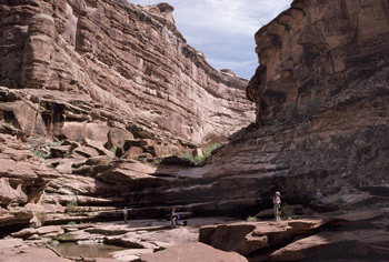 Our next obstacle (oh yeah, I remember this now) was a place just upstream of the last side canyon (12S, 569066 E, 4130831 N) coming in from the west. The canyon floor is totally choked with room-sized boulders, and the choke points have acted as a natural dam on which to skim driftwood headed downstream during floods. Getting through that point, balancing on top of a few feet of loose wood, was an experience not to be forgotten when you carry a large pack. With a day pack, it was easy. Immediately after the boulder choke, there is a lovely cascade and pool. A great place to stop for a rest break. Which we all did. After that, it was just a quick jaunt around the next bend before we were confronted was what the Idaho/MD group had referred to as impassable. Interesting how one's perspective makes all the difference. I looked at the "crux" and immediately thought: "Hey this is a lot less dangerous than it was 18 years ago." Previously, the only sane route around the huge 40 foot high pouroff required going to the right, and dropping extremely steeply down to a small shelf that had about as much standing room as a chair seat. It was necessary to lower packs and I recall that it felt pretty hairy at the time. During some flood, or earthquake, or plain old mud slide, the right wall had, as reported by the folks from Idaho, slid down into the floor of the canyon. That was the bad news. The good news was that by going just a tad higher, there looked to be some reasonable footing to cross over to more solid ground. Sure, it required using a log to get up a few feet, and there was some exposure, but it was/is not too bad. Just a couple of airy steps. Ron got up and tried it first, and seemed to have little trouble. I had to give it a try, although Susie made it clear that if Sue, having recently tasted the pain of broken bones, was not going to do it, Susie was more than happy to keep Sue company. Andy seemed to be of the same opinion. Barbara and Ray quickly followed after me. Bottom line: it is no worse than the worse stretch of the Goat Trail that we had done in Wrangell-St. Elias.
All four of us started the big descent to the canyon floor, but as I made the last turn toward the river, I could see that it was going to be a stretch of hiking in the hot sun, and Susie's being back with Sue and Andy gave me the perfect excuse to turn around 20 minutes short of seeing the river at the location I had seen 18 years ago. Climbing back up, I could see the other three sitting in the shade, with their wind shirts on. It was still pleasantly cool after you got out of the sun and hot rocks.
After a leisurely lunch, the 4 of us decided not to wait for the river hikers. I wanted to spend some more time photographing as we headed back upstream. It was really tough not to be in awe of the canyon at this point. I have been virtually the entire length of Grand Gulch now twice, and the lower end takes the cake for spectacular. Susie seemed to want to stop every few steps and just turn around with dropped jaw.
After working our way back up through the rock/log jam a few hundred meters from the pour-off, Andy and Sue picked up the pace a bit, and we, as usual, fell behind. After being with our friends all day, it was nice just to have a bit of time to ourselves. When we arrived back in camp, we found a note pinned to our stove, indicating that A&S had enough energy to head for the Perfect Kiva. Sounded to me like a great time to take a bath. It was starting to cloud up again, and I did not want to lose the opportunity to get clean before the wind picked up. 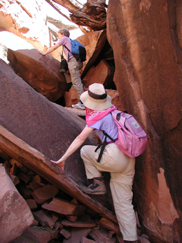 The rest of the crew was not too far behind us, reporting that while the river was way down, there simply was nothing on which to make the four mile hike upstream to the mouth of Slickhorn except exposed hot talus blocks. The fact that the river had been way up 18 years ago, leaving us no beach upon which to hike had not prevented us from making the trip. Barbara reported that it looked vastly more difficult that the stretch we had done 5 years ago between the mouth of Deer Creek and Fishtail Canyons along the Colorado in the Grand Canyon.
Dinner was a new dish for us (of course, we had tried it at home first): Orzo pasta with dried peas, chicken, spices and lots of Romano Cheese. Very tasty. I felt like sitting around and chatting after dinner, but it seemed like the weather was not going to cooperate. The temperature was falling, the clouds were building up, and it just felt like rain was imminent. Most of us spent time tidying up our camp, covering packs, and making our gear accessible from our tent doors in case of morning showers. Sure enough, about 8:15, the rain began, and so it was in tentia time. Despite the fact that the rain felt pretty light on the tent roof, I had to deal with Susie's perpetual worries about flash floods, even after it had stopped by 9 pm or so.
© Roger A. Jenkins, Suzanne A. McDonald, 2003; Crux Photo © Andrew P. Butler, 2003