
Lower Grand Gulch 2003
Shifting to Plan B
Long last day
Saturday, April 19
 Since his Central and South American volcano climbing days, my good friend Will seems to enjoy warmer experiences. As I have gotten - let's not use the term old, let's call it "more mature" - I have gone the other direction: the cooler the better. So when I awoke this morning to blue skies and 38 degrees, I was in seventh heaven. Just pull your fuzzy pants over your long underwear bottoms, your down vest and Gore-Tex over your PolarTec pullover, and live large! Of course, I opted to pour hot water into my granola, as I could use the extra warmth. It looked to be another great day. It also looked to be a long one. Essentially, we wanted to get within a few not-too-difficult miles of the Collins Canyon trail head, but still be out of the Grand Central Station atmosphere that plagues the confluence of Collins and Grand Gulch. That meant only a limited amount of time to screw around in camp.
Susie and I, perpetually the last to leave (it MUST be me), rolled out about 9:15. We didn't get far before we arrived at the first distraction. No much more than a half a kilometer above camp, there are a couple of small side canyons coming in from the east that Sue and Andy had explored the previous day, and had suggested would be worth a stop. The second one was particularly lovely, with big slickrock slabs on the canyon floor. It looked to be worth a couple of hours of poking around, but with nearly 8 miles to go this day, we simply did not have that much time. 20 minutes above the second one, our friends had put a marker in the stream bed, so that we would not walk by another ruin. It was a small granary-like structure, tucked tightly between two shelves in the eastern canyon wall. However, the inside roof of the place was charred black, suggesting that it had been used for a cooking area (it was too small to reside in). I keep promising myself that I really need to spend some more time understanding the living habits of the Anasazi, but it always gets put off under the pressure of the real world. Maybe when I retire........
 After seeing the first "other" humans in nearly four days (a couple day hiking out of their camp above Water Canyon), we caught up to our friends at what they refer to now as Rope Canyon. This is a side canyon coming in from the west (12S, 571480 E, 4137556 N ), with a long rope (actually a thick electrical cable with some of the insulation worn off) leading down some steep sections, apparently used by pot raiders to gain access to the ruins that are in the near vicinity. We spent some time poking around in the clearly excavated ruins on the canyon wall just above the mouth of Rope. There were a couple of signatures on the wall, dating back to the late 1800's, left, I am sure, by the folks who originally stole the artifacts left by the Anasazi. With our value system today, signing the wall seems the equivalent of deliberately leaving your business card at the site of a murder. I realize that our perspective on things has changed somewhat, but I hope the artifacts ended up in a museum in the Southwestern US that honors the legacy of these ancient inhabitants, not on some rich person's trophy shelf in Boston or London.
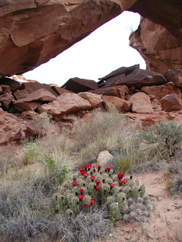
At the northern end of a straight stretch in the main canyon is the mouth of Red Man Canyon (12S, 571963 E, 4138010 N). It is called "Red Man" because there is a lovely dark red pictograph of a person at its mouth on the western wall. Or at least it was lovely until some asshole decided to use it for target practice. Two bullet pits deface the painting, a tribute to some person's enduring stupidity and tastelessness. Andy and Sue were already working their way up through the brush to see the pictograph panel when Susie and I arrived. We decided to take the easy route directly into the mouth, and see what we could see. Once you clear the initial brush and rocks, there is a nice stretch of slickrock on the canyon floor. This eventually brings you to a rock jumble which, it getting close to 1 o'clock, we simply did not have the time to pick our way through. We turned around, and Susie started to step back the way we had come, and went "Whooaaaaaa!" at the same time I heard a loud buzz. We had apparently annoyed a small rattlesnake (not the wrist-thick six foot timber rattlers we find in the Smokies). Piecing together what happened: when I moved through the first part of the rock jumble, I must have put my foot down within a few inches of the snake, curled up under a rock. Maybe I woke him up. Susie then followed me by about 30 seconds, and that just pissed him off. So when we turned around, and Susie went to step in front of him again, well, he had had enough of this shit, and was letting us know in no uncertain terms. Naturally, we had to spend some time photographing him from a safe distance. (Snake experts say that a rattlesnake can only strike out to half of its body length, but I was not ready to really test this theory.) As our friends got closer, we alerted them to the position of one annoyed snake, and of course, they had to photograph the creature as well, further making its day. We then apologized to the snake, wishing it to find a nice mouse to eat, and headed back to our packs.
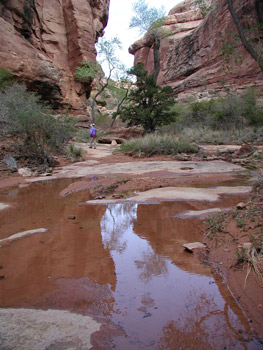
 Susie and I finished lunch near Red Canyon's mouth about 1:20 pm, and when I showed her how far we had left to go, the "Holy shit!" she exclaimed told me that there was to be no more screwing around: we had some miles to make. Which we did. We enjoyed the flowing water from Red Man to our first night's campsite, especially since the pools between Red Man and Shaw Arch had been only spotty. (A more detailed water report follows.) The couple we ran into earlier in the day, day hiking down to the Arch, had reported that their camp was "at the spring near Water Canyon." Where we actually found their camp (near12S, 572941 ,4139340 N), there indeed was a small trickle coming down a drainage from the east, but the location suggested that their map reading skills were limited. It is over 5 miles to the arch from their camp, a significant day hike in this country.
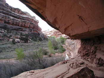
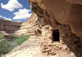
Near 12S, 572792 E, 4139745 N, we came across Andy, waiting patiently in the stream bed, while Sue looked for some ruins in a alcove. Susie and I decided to press on, as we were starting to run low on energy. Well, that worked for about ten minutes. Finally!! We had come to the "perfect granary" that Lance and I had explored 18 years ago. It is on the east wall of the canyon and it takes some figuring as to how to get to it. Susie's energy level immediately spiked, and she decided to find a way up. I excused myself, saying I could stay down below so I could photograph her up near the ruin. (Quick thinking on my part, huh?) Getting up to the ledge required going back down canyon a couple of hundred meters, moving up a seam, and then friction walking the bench back to the ruin. There are a couple of spots that bear paying attention, but by this time, Sue had shown up, and not wanting to miss such a delightful ruin, was up on the wall helping Susie around the tough spots. Obviously, Sue's post-broken-leg confidence was returning. The ruin is particularly interesting because the roof is still intact, and you can carefully stick your head in the door and get a look at the roof construction.
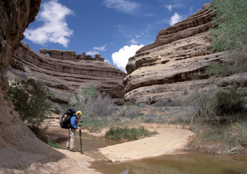 After the granary, we decided to skip the last side canyon, and focus on dragging our sorry asses into camp. We moved as fast as we could, stopping only to watch a Peregrine falcon soar near its obvious nest in a hole near the canyon rim. Water and flat space were the primary drivers now, as we knew this was just a stop over on the way out. There was a pool about 30 meters long in the canyon floor just above the mouth of a side canyon and a flat spot at 12S, 573983 E, 4140206 N. It fit the criteria, so it was home for the night. After a bath, we all started cooking dinner on a big slab of slickrock across from camp pretty quickly. Since it was our last night, Susie and I were down to the dinner that we always take with us in case the weather turns bad or we are super late getting into camp: good ole' Mountain House freeze dried Lasagna. It is tasty, but after the great "homemade" meals we had been enjoying, it is always a let down. Ray and Barbara took off, back down canyon, trying to get to some ruins they had missed earlier. Sort of a "We may never pass this way again" approach to canyon hiking. Don't want to miss a thing. I thought it was a bit foolish to take off with darkness coming on, but to each his own.
 OK. The official water report for Lower Grand Gulch for mid-April, 2003
From the river, heading upstream:
San Juan River to mouth of Shangri-La Canyon. Continuous flowing water with pools.
Mouth of Shangri-La to Shaw Arch, Intermittent pools, every few hundred meters, with occasional long stretches of dry canyon floor.
Shaw Arch to a quarter mile below the mouth of Red Man Canyon: intermittent pools.
Mouth of Red Man Canyon to one half mile above the mouth of Water Canyon: continuous flowing water.
Half mile above Water Canyon to Collins Canyon mouth: very intermittent pools, with dry stretches up to a half mile long.
The following side canyons had flowing water in them: Shangri-La, Arch (the side canyon just to the south of Shaw Arch), Red Man, and both forks of Water Canyon.
© Roger A. Jenkins, Suzanne A. McDonald, 2003