
Lower Grand Gulch 2003
Shifting to Plan B
A long way home
Tuesday, April 15 (Ron's 60th Birthday)
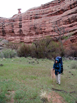 We awoke from a windy night at 6:45 am. As we were having breakfast, there was a sense of urgency about the crew: clouds were moving in, and today had been the day on the long range forecast that bad weather was to hit. About 8:15, there was just the smell of desert rain in the air, and sure enough, 10 minutes later, it started sprinkling. Of course, it was wind driven sprinkles, so it felt worse. We threw our stuff together quickly, trying to get under cover of our rain suits. We were underway at 8:34, with horizontal rain coming in. I could tell already that this would be a long day. For those folks who have not hiked in the canyons before, maybe this is a good time to discuss such. Any resemblance to backpacking on mountain trails ends with the act of carrying a load on your back. First, in the canyons, there are no trails (this always comes as a surprise to novices, until they learn about the concept of a flash flood). There are paths where people have walked. There used to be a lot of cow paths, but with the expulsion of these government subsidized degraders of the landscape (Don't get me wrong: I love beef, and eat as much as I can. But I don't want my beef to have been putting on weight at the expense of the native flora and fauna of these canyons.), things have gotten a lot better. The cow paths are healing. Second, unless you are very familiar with the particular route that you are following, picking the lowest energy trajectory is a challenging proposition. You can always cut off some distance, by climbing up on a high bench and taking a short cut. But the climb up is usually on very steep, soft sand. And you may be on very soft sand on the bench top, or you may be on nice, hard packed sand. Staying in the stream bed affords the opportunity to hike on slickrock, which is probably the easiest hiking around. But it also affords the opportunity to negotiate boulders, really soft sand, and small baseball sized rocks. It also can block your view of ruins. Or not. Any route you pick is likely to require at least 50 - 100% more energy expenditure than what would be required on a real trail. If one can average better than a mile an hour with a full backpack, you are really hauling ass.
 Which is what we were doing this morning. Parka hoods tucked in against the weather, we could feel it getting colder by the minute. We hated going by side canyons that begged to be explored, but with a day of nominally 7.5 miles ahead of us (and the prospect of being able to explore them on the way back, coming up canyon), it seemed like the prudent thing to do. I confessed to Susie that I had hoped it would rain hard enough to generate a few waterfalls, but such was not the case. The rain stopped after about an hour, but it did resume intermittently throughout the morning, in the form of either soft sleet or very hard rain. But walking was OK. My strained back did not hurt as much as I had expected it would, and it seemed like we were making good progress. Indeed we were. We passed the Arch at 11:45, and it was (upon careful measurement back home with the digital topo map - nominally 4.5 miles downstream from our campsite. After passing the arch, we noted that Sue and Andy were up in the rincon just downstream of it, presumably chasing ruins. It was clear that Sue's confidence was building.
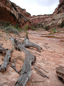
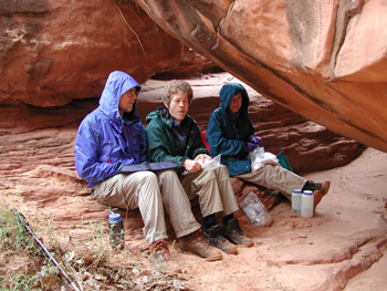
Susie and I decided to stop for lunch, but just as we sat down, the rain and wind picked up, so we packed up and headed down canyon seeking shelter. We eventually found a boulder oriented correctly, and over the course of the next 20 minutes or so, it became a people magnate, as everyone (except for Barbara and Ray, whom we had not seen for a long time) pulled in to get out of the weather. It was cramped, but such had the advantage of offering additional warmth from the bodies pressed together. It was not long after lunch before the clouds seemed to be lifting a bit. Nice to be in the sun for awhile, since the air was still cool. Downstream from the arch about a mile or so is an interesting process to watch. Lower Grand Gulch has a number of abandoned meanders in this stretch, where the flow of water has short-circuited the ancient streambed, cutting a more direct route. At 12S, 571250 E, 4134367 N, there is one of this rincons in the making: the streambed is still following the pre-historic stream channel, but the wind and other forms of erosion has cut down the rock that forms the bend in the canyon to the point that it is just a hill of sand. All that remains of the original fin is 2-acre size pillar. The hiking route is up and over the sand hill, and it is just a geologic blink of an eye before the water erodes the sand hill and the stream takes the channel shortcut. The climb up over this hill is a substantial distance savings, and provides a good overview of the phenomenon.
 All day I had been feeling a change in the canyon character, and the trip over the sand hill confirmed my suspicions (as well as running an elevation profile of the canyon floor upon returning home): in the stretch from the mouth of Collins Canyon to a couple of miles below last night's camp, the canyon floor is pretty much flat. It loses only about 100 feet in those 6 miles. But about 500 meters below the mouth of Red Man Canyon, LGG seems to pitch over and head for the river. The change in elevation profile is dramatic, as the canyon floor nearly triples its slope. Unlike the upper canyon, you can really see that the end of a stretch of canyon is definitely lower than the beginning of the stretch. The change in water velocity is probably a contributor to the large number of rincons in this length of canyon. Hey, I had to think of something as my pace down canyon started to crawl. The afternoon had turned nice, and at a rest break, I noticed that we were a mere 600 meters or so from the mouth of Shangri La canyon, and that meant camp!! I could feel my back really starting to stiffen, and it was time to get the pack off.
 We pulled into the spot across from the mouth of Shangri La Canyon (it is not named that on any maps that I have seen, but that is what the Rangers call it) about 3:45 pm, a bit over seven hours to make the 8.2 mile distance from last night's camp. Not too bad. Sue had been there a half hour or so and had scouted for campsites. There was the spot right across from the mouth where the Idaho/Maryland three person group looked to have camped last night, and while it was fine for a couple of tents, it lacked shade: most of the rest of the tents would be in the sun all day. Sue had found another spot down stream maybe 150 meters or so, and it looked better to me, although Ray was clearly not happy with it. He later confessed that he did not like sites with tall grass and other vegetation around. But he lost the vote, so we decided to stay at the second spot that Sue had found (12S, 570648 E, 4131769 N). My memory had been that in ‘85, a group of college students that seem to be more into nudity than hiking had camped at a really nice site just downstream a bit, but when I went down to check things out, the spot clearly was not there. It is tough to admit that your memory is not as clear as you would like it to be.
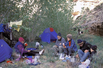
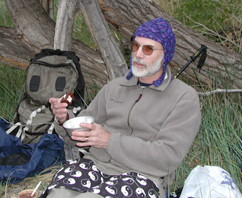 As we were setting up camp, the Idaho/MD party of three came by. They reported that their plan was to have camped down by the San Juan River. However, a slide had washed away what they said was the way to get to the river, forcing one to go way up into the talus. They thought such was too dangerous to go any further, and so turned around. Despite their lack of friendliness, we joked that we had saved their last night's camp for them. They grudgingly said thanks and moved upstream. It would be the last time we would see any other humans but ourselves for nearly four days. We returned to preparing dinner. The community kitchen was a bit on the small side. It was cosy, and offered some protection from the breeze/wind. Around 5 pm or so, it had started to cloud up again, but it looked like it would clear off before bedtime. Dinner was Hamburger Helper Beef Stroganoff for Susie and I. After dinner, we surprised Ron with a Birthday cupcake. We had learned back at the Knoxville Airport from Ginger, his wife, that he would turn 60 today. So Susie and I had spared no expense at some gas station in Blanding to buy him some Hostess Cupcakes. To honor the birthday, we stuck a wooden twig in the cupcake (Hey, he only got one. The other six of us had to share the other one.) and set it on fire. Sort of a makeshift candle. We didn't did not stay up late tonight. It had been a long day getting here, and even though none of us could remember spending 3 consecutive nights in the same camp on a week long trip, our fatigue outweighed our perception of our ability to sleep late. It is hell getting old.
© Roger A. Jenkins, Suzanne A. McDonald, 2003